Extreme Weather News

Jump to a Year

2022 | 2021 | 2020 | 2019 | 2018

2017 | 2016 | 2015 | 2014 | 2013

2012 | 2011 | 2010 | 2009 | 2008

2007 | 2006 | 2005 | 2004 | 2003

2002

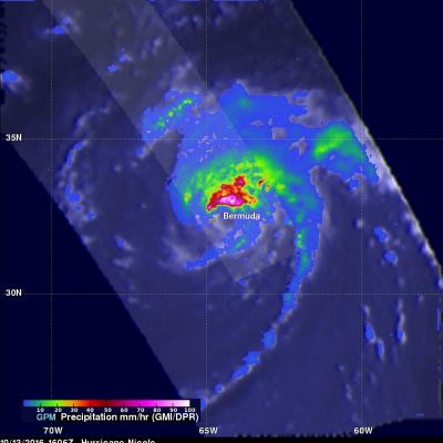
Hurricane Nicole Moving Over Cold North Atlantic

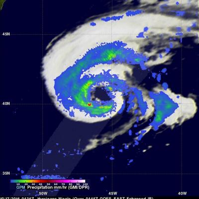
Hurricane Nicole has now been active for almost two weeks. Nicole was still a hurricane with winds of about 70 kts (81 mph) when the GPM core observatory satellite flew over on October 17, 2016 at 0436 UTC (2:36 am EDT). The GPM satellite had a good look at the rainfall in Nicole's large ragged eye. GPM's Dual-Frequency Precipitation Radar (DPR) swath sliced through the center of Nicole's eye and found some very heavy rainfall. A few strong storms in the southern side of the eye were dropping rain at a rate of over 113 mm (4.4 inches) per hour. GPM's radar (DPR KU band) data collected with

Hurricane Nicole Lashes Bermuda

While powerful Hurricane Matthew drew a lot of attention as it made its way through the northern Caribbean and the Bahamas before ravaging the US East Coast with strong winds and massive flooding, another storm was lurking nearby in the western Atlantic--Nicole. Nicole, which like Matthew, also originated from a tropical wave that made its way across the central Atlantic from the coast of Africa. Nicole first became a tropical storm on the morning of the 4th of October about 525 miles northeast of San Juan Puerto Rico just after Matthew, a powerful Category 4 storm at the time, had devastated

Deadly Hurricane Matthew's Total Rainfall

Hurricane Matthew devastated western Haiti and killed over 1,000 people. Matthew also took the lives of at least 37 deaths in the United States with 18 deaths occurring in the state of North Carolina. Flooding is still widespread in North Carolina. Some rivers in North Carolina such as the Tar and the Neuse are still rising. This rainfall analysis was accomplished using data from NASA's Integrated Multi-satelliE Retrievals for GPM (IMERG). IMERG is a unified U.S. algorithm that provides a multi-satellite precipitation product. IMERG is run twice in near-real time with the “Early” multi

Matthew Brings Heavy Rains, Destruction to Parts of the Northern Caribbean

Matthew began as a fairly impressive tropical wave that emerged off of the coast of Africa on the 23rd of September but had to make its way all the way across the Central Atlantic before finally organizing into a tropical storm on the morning of the 28th while passing through the Windward Islands. Matthew then slowly but steadily intensified into a minimal hurricane by the early afternoon of the following day as it continued to track westward through the central eastern Caribbean. The next day, September 30th, Matthew underwent a period of rapid intensification; its winds increased in
GPM Sees Hurricane Matthew Nearing Florida
UPDATE 10/6/16: NASA's Global Precipitation Measurement mission or GPM core observatory satellite flew over Hurricane Matthew several times as the category 4 storm headed toward Florida. The GPM Core Observatory carries two instruments that show the location and intensity of rain and snow, which defines a crucial part of the storm structure – and how it will behave. The GPM Microwave Imager sees through the tops of clouds to observe how much and where precipitation occurs, and the Dual-frequency Precipitation Radar observes precise details of precipitation in 3-dimensions. This data...