

Ground Validation Data
GPM Ground Validation Data Homepage: http://gpm-gv.gsfc.nasa.gov/
GPM Ground Validation Data Access: https://ghrc.nsstc.nasa.gov/pub/fieldCampaigns/gpmValidation/
The goal of this site is to provide a one-stop-shopping portal for accessing the various radar, disdrometer, gauge and other instrument data sets supporting GPM GV activities. Use the tabs above to access the various datasets, including:
- Radar
- Gauge
- Disdrometer
- NOAA/NMQ
- Field Campaigns
- Validation Network
- Wallops Precipitation Research Facility
- Marquette data browser (GV data from the Marquette, Michigan NWS Snowfall Observation Site)
GPM GV Field Campaign Collection DOIs
GHRC has created collection level DOIs that resolve to field campaign landing pages for each of the Global Precipitation Measurement (GPM) Ground Validation (GV) field campaigns. The field campaign collection landing pages contain an introduction to the purpose, location,and time of the field campaign, the collection citation, general characteristics, member dataset links, and primary documentation relevant to the field campaign. We are currently adding the Field Campaign Collection DOI to metadata for each data product. The landing pages are:
- The Olympic Mountains Experiment (OLYMPEX): http://dx.doi.org/10.5067/GPMGV/OLYMPEX/DATA101
- The Integrated Precipitation and Hydrology Experiment (IPHEx): http://dx.doi.org/10.5067/GPMGV/IPHEX/DATA101
- The Iowa Flood Studies (IFloodS): http://dx.doi.org/10.5067/GPMGV/IFLOODS/DATA101
- The Midlatitude Continental Convective Clouds Experiment (MC3E): https://doi.org/10.5067/GPMGV/MC3E/DATA101
- The GPM Cold-season Precipitation Experiment (GCPEx): https://doi.org/10.5067/GPMGV/GCPEX/DATA101
- The Light Precipitation Evaluation Experiment (LPVEx): https://doi.org/10.5067/GPMGV/LPVEX/DATA101
System for Integrating Multi-platform data to Build the Atmospheric column (SIMBA)
Motivated by NASA's Global Precipitation Measurement (GPM) mission and Ground Validation objectives, the System for Integrating Multi-platform data to Build the Atmospheric column (SIMBA) has been developed as a unique multi-sensor precipitation data fusion tool to unify field observations recorded in a variety of formats and coordinate systems into a common reference frame.
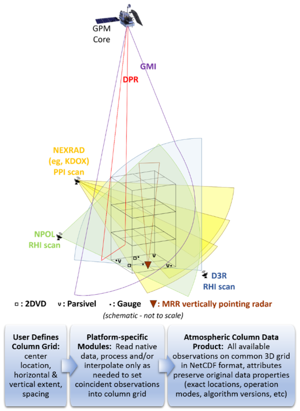
Through platform-specific modules, SIMBA processes data from native coordinates and resolutions only to the extent required to set them into a user-defined, three-dimensional grid. At present, the system supports several ground-based scanning research radars, NWS NEXRAD radars, profiling Micro Rain Radars (MRRs), multiple disdrometers and rain gauges, soundings, the GPM Microwave Imager and Dual-frequency Precipitation Radar on board the Core Observatory satellite, and Multi-Radar/Multi-Sensor quantitative precipitation estimates. SIMBA generates a new atmospheric column data product that contains a concomitant set of all available data from the supported platforms within the user-specified grid defining the column area in the versatile NetCDF format, with key parameters for each data source preserved as attributes.