Extreme Weather News

Jump to a Year

2022 | 2021 | 2020 | 2019 | 2018

2017 | 2016 | 2015 | 2014 | 2013

2012 | 2011 | 2010 | 2009 | 2008

2007 | 2006 | 2005 | 2004 | 2003

2002

GPM Sees Deadly Tornadic Storms Moving Through The Southeast

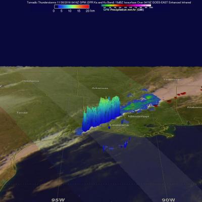
On Tuesday evening through Wednesday morning tornadoes formed along a squall line in advance of a cold front that moved through the Southeast. Over three dozen tornadoes were reported with sightings occurring in Louisiana, Alabama, Mississippi, Tennessee and Alabama. Tornadoes caused the deaths of a least five people in northern Alabama. Storms also took the the lives of two people in Tennessee. This Rainfall may provide some relief to drought ridden eastern Tennessee where destructive wildfires have been occurring. Some storms were accompanied with hail, strong winds and intense showers. Golf

Deadly Hurricane Otto Strikes Nicaragua and Costa rica

Hurricane Otto hit the southern coast of Nicaragua on November 24, 2016 at about 1800 UTC (1 PM EST). Otto had winds of about 95 kts (109 mph). The hurricane crossed into Nicaragua just north of the town of San Juan de Nicaragua that is located at 10.9 degrees North latitude. This makes Otto the southernmost land falling hurricane in Central America on record. Otto dropped flooding rainfall as is weakened and moved through northwestern Coast Rica. Otto was still a well organized tropical storm when it moved into the Eastern Pacific early on November 25, 2016. Otto's maximum sustained winds had

Tropical Storm Otto Develops, Threatens Central America

Tropical storm Otto formed in the southwestern Caribbean north of Panama on November 21, 2016. The GPM core observatory satellite had an excellent daytime view of the newly formed tropical storm on November 21, 2016 at 1906 UTC (2:06 PM EST). Otto had wind speeds estimated at 45 kts (52 mph) at that time. GPM satellite rainfall data are shown overlaid on a visible and infrared image captured by the GOES-EAST satellite at 1915 UTC (2:15 PM EST). GPM's Microwave Imager (GMI) and Dual-Frequency Precipitation Radar (DPR) revealed that the newly formed tropical storm had deep convective bursts in

Deadly Tropical Rainfall Examined by IMERG

Scattered to numerous showers and scattered thunderstorms have occurred over Hispaniola during the past week. Slow moving frontal systems draped over Hispaniola and a tropical wave recently caused heavy rainfall that led to wide spread flooding over the northern Dominican Republic. Over 20,000 people have been displaced from their homes and at least five deaths have been reported. A broad area of low pressure (90L) in the southwestern Caribbean is also being monitored for possible tropical cyclone development by the National Hurricane Center (NHC). Very warm sea surface temperatures and upper

Tropical Depression MA-ON Evaluated With GPM Data

Tropical cyclones have been forming frequently in the Western Pacific Ocean since July 2016. 36 named tropical cyclones have formed in the Western Pacific in less than 5 months with 14 of them becoming typhoons. Tropical Depression MA-ON Formed on November 10, 2016 northeast of Guam. MA-ON had maximum sustained winds estimated at 30 kts (34.5 mph) when the GPM core observatory satellite flew over on November 10, 2016 at 0701Z. GPM's Microwave Imager (GMI) and Dual-Frequency Precipitation Radar (DPR) instruments showed that the tropical depression contained some very heavy showers. Strong bands