Photograph of a landslide on a mountain.

Landslides

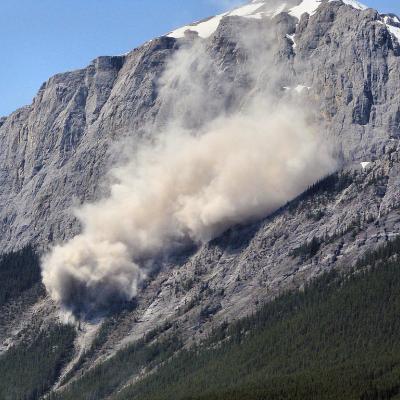
Landslides are one of the most pervasive hazards in the world, resulting in more fatalities and economic damage than is generally recognized. Every year they block roads, damage infrastructure, and cause thousands of fatalities. Intense and prolonged rainfall is the most frequent landslide trigger around the world, but earthquakes and human influence can also cause significant and widespread landsliding. Using satellite data, we can identify the conditions under which landslides typically occur, helping to improve monitoring and modeling of these hazards

Sections

Rainfall Triggered Landslides

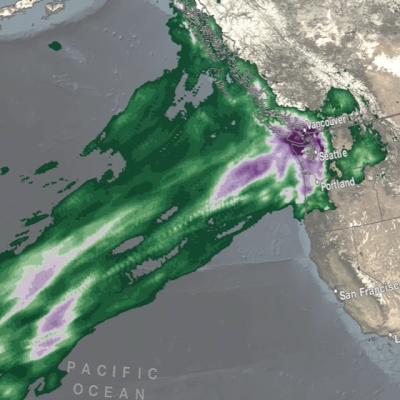
Researchers need accurate and timely rainfall information to better understand and model where and when severe floods, frequent landslides and devastating droughts may occur. GPM's global rainfall data will help to better prepare and respond to a wide range of natural disasters.

This video is public domain and can be downloaded at: http://svs.gsfc.nasa.gov/goto?11091 

Modeling and Reporting Landslides

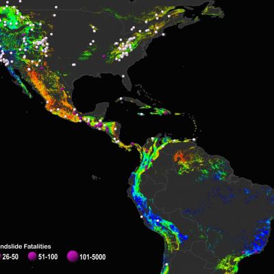
The global Landslide Hazard Assessment for Situational Awareness (LHASA) model was developed to provide situational awareness of landslide hazards for a wide range of users. The model combines GPM near real-time precipitation data with a global landslide susceptibility map to generate estimates of where and when rainfall-triggered landslides are likely to occur around the world. Information on landslide reports is available on the Cooperative Open Online Landslide Repository (COOLR), which combines data from NASA's Global Landslide Catalog, other landslide inventories and contributions from citizen scientists via the Landslide Reporter Application.

Image

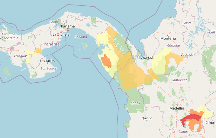
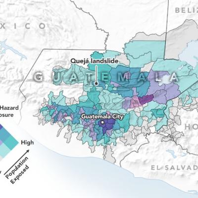
An example of the LHASA 2.0 landslide nowcast in South and Central America. Red indicates larger populations exposed to landslide hazard. Orange and yellow indicate lesser population exposure. Image from Landslide Viewer.

LHASA 2.0 was recently released, which improves upon LHASA 1.1 by incorporating landslide inventories from around the world within a machine learning framework that estimates the relative probability of landslide occurrence. LHASA 2.0 also estimates the potential exposure of human populations and roads to landslide hazard and maps the basins likely to experience post-fire debris flows. 

Learn More:

Related Articles
IMERG rainfall totals from the Nov. 2021 atmospheric river.
The Pacific Northwest coast saw two atmospheric rivers (ARs) bring heavy rains from Nov. 10-16, 2021, resulting in severe flooding, landslides, and damage to infrastructure in the British Columbia province of Canada. ARs are long, narrow corridors of water vapor that travel vast distances above the ocean from warm, tropical regions to higher latitudes, where they often release their moisture as rainfall when they reach land areas. While ARs occur across the globe, this year has been notable for several strong events that have impacted the Pacific Northwest coast. The two atmospheric rivers in
World Resources Institute Ethiopia
NASA’s Earth observation data are used in a wide variety of ways to improve life for humans and other animals across the world every day. Our climate is changing, and these changes include differences in temperature and precipitation patterns around the globe. As you might imagine, these changes bring about both anticipated and unanticipated consequences that have a profound impact on people around the world. Many organizations are responding to the amazing yet complicated wealth of data that can be used to successfully monitor many aspects of our global environment. The World Resources
Landslide Risk in Central America
On November 3, 2020, Hurricane Eta made landfall as one of the most powerful hurricanes to hit Central America in years. The category 4 storm destroyed hundreds of homes, killed more than 100 people, and brought torrential rains that triggered large and numerous landslides in Guatemala and Honduras. Less than two weeks later, Hurricane Iota —an even more powerful category 4 storm—nearly retraced Eta’s path. Within hours of Eta’s landfall and flooding rains , researchers at NASA’s Goddard Space Flight Center worked to predict landslides and map the storm’s aftermath. One team assessed potential
Hurricane Eta IMERG Screenshot
The extremely active 2020 Atlantic hurricane season, aided by the ongoing La Niña, continues on. After Hurricane Zeta made landfall along the northern part of the Gulf Coast, yet another hurricane has arisen - Hurricane Eta, the strongest of the season. Like Zeta, Eta also formed in the Caribbean, where sea surface temperatures are still running quite warm at around 29° C, almost a full degree above average and well above the typical 26° C needed for tropical cyclone development. But while Zeta turned north into the Gulf of Mexico, Eta moved westward where it delivered powerful winds and
Landslide Risk in High Mountain Asia
More frequent and intense rainfall events due to climate change could cause more landslides in the High Mountain Asia region of China, Tibet and Nepal, according to the first quantitative study of the link between precipitation and landslides in the region. The model shows landslide risk for High Mountain Asia increasing in the summer months in the years 2061-2100, thanks to increasingly frequent and intense rainfall events. Summer monsoon rains can destabilize steep mountainsides, triggering landslides. Credits: NASA's Earth Observatory/Joshua Stevens High Mountain Asia stores more fresh...
GPM Data Mitigates Landslide Risks in Bangladesh
Camp managers and other local officials overseeing Rohingya refugee camps in Bangladesh are now incorporating NASA satellite observations into their decision making in order to reduce the risk to refugees from landslides and other natural hazards. Information like daily rain totals can help inform how to lay out refugee camps and store supplies. More than 740,000 Rohingya refugees have fled to Bangladesh since August 2017. Many of them have sought shelter in camps located in the hilly countryside, where landslide risk may be the greatest. Increasing this danger is Bangladesh’s intense monsoon season. Approximately 80 percent of Bangladesh's yearly rain falls in just five months, from June to October, bringing with it an increased risk of flash flooding and landslides.
Help NASA Create the Largest Landslide Database
Landslides cause thousands of deaths and billions of dollars in property damage each year. Surprisingly, very few centralized global landslide databases exist, especially those that are publicly available. Now NASA scientists are working to fill the gap—and they want your help collecting information.
Modeling Landslide Threats in Near Realtime
For the first time, scientists can look at landslide threats anywhere around the world in near real-time, thanks to satellite data and a new model developed by NASA. The model, developed at NASA's Goddard Space Flight Center in Greenbelt, Maryland, estimates potential landslide activity triggered by rainfall. Rainfall is the most widespread trigger of landslides around the world. If conditions beneath Earth's surface are already unstable, heavy rains act as the last straw that causes mud, rocks or debris — or all combined — to move rapidly down mountains and hillsides. A new model has been...
http://earthobservatory.nasa.gov/IOTD/view.php?id=88319
As farmers in Nepal prepare for the benefits of monsoon season, Dalia Kirschbaum anticipates the dangers of those torrential rains—mainly, the loosening of earth on steep slopes that can lead to landslides. In this mountainous country, 60 to 80 percent of the annual precipitation falls during the monsoon (roughly June to August). That’s when roughly 90 percent of Nepal’s landslide fatalities also occur, according to a 2015 report from the United Nations Office for the Coordination of Humanitarian Affairs. “We know a high number of landslides occur around this time, so documenting them is...
Aerial photo of 2010 landslide in Gansu, China
By Lisa-Natalie Anjozian , NASA Goddard Space Flight Center Original www.nasa.gov Press Release (published 11/27/12) A NASA study using TRMM satellite data revealed that the year 2010 was a particularly bad year for landslides around the world. Around midnight on August 8, 2010, a violent surge of loosened earth roared down mountain slopes and slammed into quietly sleeping neighborhoods in Zhouqu County in Gansu, China. The catastrophic mudslides—the deadliest in decades according to state media—buried some areas under as much as 23 feet (7 meters) of suffocating sludge. 1,765 people died...

Hide Date