Extreme Weather News

Jump to a Year

2022 | 2021 | 2020 | 2019 | 2018

2017 | 2016 | 2015 | 2014 | 2013

2012 | 2011 | 2010 | 2009 | 2008

2007 | 2006 | 2005 | 2004 | 2003

2002

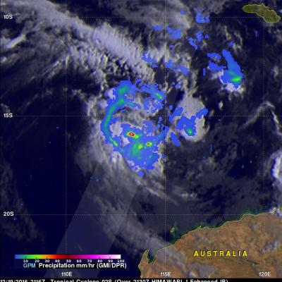
GPM Finds Rainfall Increasing With Tropical Cyclone Yvette

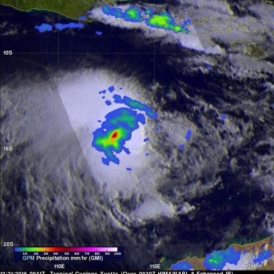
The GPM core observatory satellite again flew over tropical cyclone Evette (02S), located off the northwestern coast of Australia, on December 21, 2016 at 0941 UTC. Maximum sustained winds had increased to about 40 kts (46 mph). The GPM satellite's Microwave Imager (GMI) revealed that the area of continuous rainfall around Yvette's center of circulation had increased in size. Convective storms were shown by GPM to be dropping rain at rates of over 60 mm (2.4 inches) per hour. Tropical cyclone Yvette is predicted to intensify slightly by tomorrow to about 50 kts (58 mph). Yvette continues to be

Tropical Cyclone 02S Formation Observed By GPM

Australia is normally affected by 11 cyclones a year but only three formed during Australia's last summer. This year sea surface temperatures in the tropical waters around Australia are much warmer so an average tropical cyclone is forecast by the Bureau of Meteorology (BOM). Tropical cyclone 02S formed in the Indian Ocean northwest of Australia yesterday. Another tropical cyclone is also expected to form soon in an area of intense convection west-northwest of Darwin, Australia. The GPM core observatory satellite flew above tropical cyclone 02S just a few hours after it's formation on December

GPM Sees Tropical Cyclone Vardah (05B) Intensifying

The GPM core observatory satellite had another excellent view of tropical cyclone Vardah (05B) in the eastern Bay of Bengal on December 8, 2016 at 0301 UTC. GPM found that Vardah had become better organized since it formed on December 7, 2016. Maximum sustained winds had increased to an estimated 45 kts (~52 mph). GPM's Microwave Imager (GMI) showed that two intense feeder bands were bringing moisture from the Andaman Sea into the northeastern side of the tropical cyclone. GPM's Dual-Frequency Precipitation Radar (DPR) coverage is shown in a slightly lighter shade through the center of the

Forming Tropical Cyclone Examined By GPM

A tropical cyclone (TC05b) formed on December 7, 2016 in the eastern Bay Of Bengal. The Joint Typhoon Warning Center (JTWC) issued it's first advisory when TC05B was located just west of the Andaman and Nicobar Islands with winds of 35kts (~40 mph). On December 6, 2016 at 1441 UTC the GPM core observatory satellite passed over the forming tropical cyclone. This image shows a rainfall analysis that was derived from GPM's Microwave Imager (GMI) and Dual-Frequency Precipitation Radar (DPR) data. GPM's radar (DPR Ku band) showed that the forming tropical cyclone had two bands of convective storms

GPM Measures The Altitudes of Hawaii's Rain And Snow

The mountains of Mauna Kea and Mauna Loa in the Hawaiian Islands have recently received heavy snowfall. Hawaii's balmy temperatures normally reach above 80 degrees Fahrenheit (27 C) at sea level on beaches such as Oahu's Waikiki but temperatures fall below freezing at the altitudes of tall mountain peaks on the Big Island. At 13,802 feet (4.2 km) Mauna Kea is Hawaii's tallest mountain. Snowfall is frequently seen on Mauna Kea's peak. The nature of precipitation in the Hawaiian Islands was recently examined using data collected by the GPM core observatory satellite. GPM flew over the Hawaiian