Extreme Weather News

Jump to a Year

2022 | 2021 | 2020 | 2019 | 2018

2017 | 2016 | 2015 | 2014 | 2013

2012 | 2011 | 2010 | 2009 | 2008

2007 | 2006 | 2005 | 2004 | 2003

2002

GPM Sees the Formation of Early Atlantic Ocean Tropical Depression 1

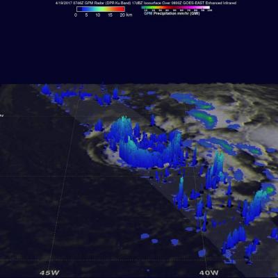
A low pressure area in the Atlantic Ocean, located southwest of the Azores was designated as Subtropical Depression One on April 19 as NASA examined its rainfall. By April 20 it had become the Atlantic's first tropical depression. Just as the subtropical depression was forming in the North Atlantic Ocean on April 19 at 11 a.m. EDT (1500 UTC) the Global Precipitation Measurement Mission or GPM core observatory satellite flew directly over it and identified areas where rainfall was heaviest in the system. Data collected by GPM's Microwave Imager (GMI) and Dual-Frequency Precipitation Radar (DPR)

GPM Sees Tropical Cyclone Maarutha Develop

Tropical Storm Maarutha became the first tropical cyclone of 2017 in the Bay of Bengal when it formed on April 15, 2017. Maarutha intensified slightly as it moved northeastward toward Burma (Myanmar). Maarutha reached it's maximum sustained wind speed of 45 kts (52 mph) over the open waters of the Bay Of Bengal. The GPM core observatory satellite had a good view of the forming tropical cyclone on April 14, 2017 at 0121 UTC when it was in the Bay Of Bengal west of the Andaman Islands. GPM had another excellent view just before the organizing tropical cyclone was designated tropical storm

New Zealand's Extreme Rainfall Examined With IMERG

Two extra-tropical cyclones recently dropped very heavy rain over New Zealand. Tropical cyclone Debbie dumped extreme amounts of rain over the northeastern coast of Australia when it hit the Queensland coast on March 28, 2017. After drenching northeastern Australia Extra-tropical Cyclone Debbie transported a river of water over New Zealand last week. Debbie's remnants dropped heavy rainfall that caused widespread flooding near the Bay of Plenty on New Zealand's northeastern coast. Thousands of residents needed to be evacuated with extra-tropical cyclone Debbie. This week extra-tropical cyclone

Texas' Heavy Rain Measured By IMERG

Over the past few days a slow moving frontal system moving through the Southwest produced heavy rain resulting in flooding and mudslides over central Texas. One person was reported swept away by flood water near Fort Hood Texas. NASA's Integrated Multi-satellitE Retrievals for GPM (IMERG) data were used to provide an estimate of rainfall accumulation over Texas. From April 10-12, 2017 IMERG estimates indicate that over 8 inches (203 mm) of rain fell in the area from central Texas through northern Louisiana.
GPM Catches Nor'easter over New England
At the time of the Global Precipitation Measurement (GPM) Core Observatory overpass (April 1, 2017, 0550 UTC), the storm's center of low pressure was south of Long Island. At the mid-levels of the atmosphere, the circulation was centered over northeast Pennsylvania. This led to a classic overrunning, warm conveyor setup, which happened when the counterclockwise low level flow drew in cold air out of the north/northeast (hence "Nor'easter") from Canada. Higher up, warm and moist air from further south was lifted over this cold air and resulted in precipitation in the form of snow at the surface...