Extreme Weather News

Jump to a Year

2022 | 2021 | 2020 | 2019 | 2018

2017 | 2016 | 2015 | 2014 | 2013

2012 | 2011 | 2010 | 2009 | 2008

2007 | 2006 | 2005 | 2004 | 2003

2002

Tropical Cyclone Donna's Rain Unveiled By GPM

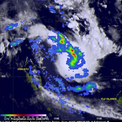
Tropical Cyclone Donna formed in the South Pacific Ocean northeast of Vanuatu On May 2, 2017 at 1800 UTC. A few hours earlier at 1521 UTC the GPM core observatory satellite passed above that area. GPM's Microwave Imager (GMI) instrument provided a clear view of the rainfall associated with the forming tropical cyclone. GMI revealed that an intense rain band was wrapping into the center of the forming tropical cyclone from the northern side. GMI data indicated that precipitation in one of these intense rain bands was falling at a rate of over 53 mm (~2 inches) per hour. GPM's Dual-Frequency

Extreme U.S. Rainfall Analyzed With IMERG Data

Tornadoes have accompanied severe weather over the United States almost daily during the past week. Severe storms spawned tornadoes from Texas and Oklahoma eastward through Mississippi. Upper Midwest states such Illinois, Indiana and Kentucky were also visited by tornadoes. Extreme rainfall caused deadly flooding in Missouri. More than a dozen people in the Midwest and South have been reported killed by tornadoes or flooding. The same weather system is spreading severe storms through East and Northeastern states today. NASA's Integrated Multi-satelliE Retrievals for GPM (IMERG) data were used

Intensifying Tropical Cyclone Francis Inspected By GPM

Tropical cyclone Francis formed north of Melville Island, Australia on April 27, 2017. Francis has been gradually intensifying while moving south-southwestward through the Timor Sea. Francis had maximum sustained winds estimated at 50 kts (57.5 mph) when the GPM core Observatory flew over on April 27, 2017 at 1936 UTC. The rainfall analysis shown here used data collected by GPM's Microwave Imager (GMI) and Dual-Frequency Precipitation Radar (DPR) instruments. DPR data indicated that strong convective storms near the center of the tropical storm were dropping rain at a rate of over 70 mm (2.8

Tropical Depression 03W In The Pacific Examined By GPM

Tropical Depression 03W formed in the Pacific Ocean west of Guam on April 24, 2017. The GPM core observatory satellite had an excellent view of TD03W when it flew over on April 14, 2017 at 1901 UTC. The GPM satellite found that the newly formed tropical depression contained some very powerful convective storms. Intense storms in the middle of the organizing convective cluster were dropping precipitation at extreme rates. GPM's Microwave Imager (GMI) and Dual-Frequency Precipitation Radar (DPR) instruments unveiled tall convective storm towers on the eastern side of this cluster of storms that

Arlene Becomes Rare Atlantic Tropical Cyclone

Tropical storms are quite rare in the Atlantic at this time of the year, which is why the formation of Tropical Storm Arlene in the north Central Atlantic yesterday, Thursday April 20th at 5:00 pm EDT, was so unusual. The National Hurricane Center (NHC) noted that Arlene became only the 2nd tropical storm to form in the Atlantic during the month of April in the entire satellite era, the other being Tropical Storm Ana back in 2003. GPM captured this timely image of Arlene just after the NHC officially designated it to be a tropical storm. The image was taken at 21:56 UTC (5:56 pm EDT) on