Extreme Weather News

Jump to a Year

2022 | 2021 | 2020 | 2019 | 2018

2017 | 2016 | 2015 | 2014 | 2013

2012 | 2011 | 2010 | 2009 | 2008

2007 | 2006 | 2005 | 2004 | 2003

2002

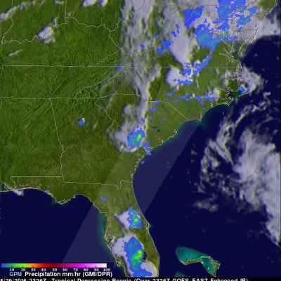
GPM Sees Bonnie as a Tropical Depression Again

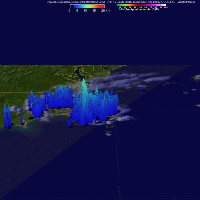
Tropical storm Bonnie weakened to a tropical depression on May 29, 2016. The circulation was labeled as "Post-Tropical" and has been moving very slowly to the northeast near the Carolinas coastline. Bonnie developed organized convection near the center and the system has again been labeled a tropical depression. The GPM core observatory satellite saw Tropical Depression Bonnie on June 1, 2016 at 2226 UTC (6:26 PM EDT). GPM's Microwave Imager (GMI) and and Dual-Frequency Precipitation Radar (DPR) instruments measured precipitation in a few powerful convective thunderstorms falling at a rate of

GPM Examines Tropical Depression Bonnie In The Carolinas

The GPM core observatory satellite had an excellent view of Tropical Depression Bonnie as it flew over the southeastern United States on May 29, 2016 at 2326 UTC (7:26 PM EDT). Rainfall was analyzed using data collected by GPM's Microwave Imager (GMI) and and Dual-Frequency Precipitation Radar (DPR) instruments. GPM's radar (DPR) showed rain falling at a rate of over 25.4 mm (1 inch) per hour in South Carolina. GPM's Radar (DPR Ku Band) was able to see through cloud cover in the tropical depression and show the vertical shape of rain within storms. The heights of storm tops were derived from

Deadly Flooding Rainfall Over Texas And Tropical Storm Bonnie Measured From Space

Heavy rainfall caused deadly flooding in southeastern Texas. At least 4 people have been killed and continuing rainfall is expected to cause historic flooding in that area. Meanwhile, dissipating Tropical storm Bonnie is soaking the South Carolina coast, southeastern North Carolina and eastern Georgia on this Memorial Day weekend. Some flooding is expected as dissipating tropical storm Bonnie's rainfall moves northeastward along the coast. This analysis of liquid precipitation from space was accomplished by using merged satellite rainfall data from the TRMM Multi-satellite Precipitation

GPM Sees Potential Atlantic Tropical Cyclone

An area of low pressure located in the Atlantic Ocean between Bermuda and the Bahamas is being monitored today for possible development into a tropical or subtropical cyclone. Shower activity has increased in the area. The National Hurricane Center (NHC) has advised interests along the southeastern coast of the United States to monitor the progress of this low. The GPM core observatory satellite flew over this showery area on May 26, 2016 at 0932 UTC (5:30 AM EDT). GPM's Microwave Imager (GMI) and and Dual-Frequency Precipitation Radar (DPR) instruments measured precipitation around the low

Developing Tropical Storm Triggers Deadly Landslides in Sri Lanka

A storm does not have to be especially powerful in terms of its winds to be deadly. Such is the case with Tropical Cyclone 01B (TC 01B) in the Bay of Bengal. Despite only reaching minimal tropical storm intensity just this morning at 06 UTC 18 May 2016, the system has been responsible for dumping heavy rains in and around Sri Lanka and southern Indian over the past few days as it tried to organize itself in the southwestern Bay of Bengal. This set the stage for two massive landslides, which buried 3 villages in south central Sri Lanka. So far, although several hundred people have been rescued