Extreme Weather News

Jump to a Year

2022 | 2021 | 2020 | 2019 | 2018

2017 | 2016 | 2015 | 2014 | 2013

2012 | 2011 | 2010 | 2009 | 2008

2007 | 2006 | 2005 | 2004 | 2003

2002

GPM IMERG Sees Flooding in France

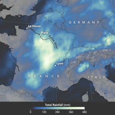
In June 2016, a slow-moving weather system unleashed several days of heavy downpours on western Europe, pushing the Seine River to heights not seen in 34 years. With the Seine’s water levels 6.1 meters (20 feet) above normal in Paris, flood waters knocked out electricity for thousands of people, interrupted road and rail traffic, shut down schools, and caused an estimated 1 billion euros of damage. During the worst of the flooding, the world’s most visited museum, the Louvre, closed as employees scrambled to move artwork out of basement areas that were at risk of flooding. The map above

Tropical Storm Colin's Heavy Rainfall Examined From Space

Earlier this week the Governor of Florida declared a state of emergency as tropical storm Colin moved over the state. In just a few days heavy rainfall from the tropical storm spread from Florida's Gulf Coast through Georgia to the North Carolina coastline. Street flooding was common in Florida. Severe flooding was not reported but over 250 mm (10 inches) of rain was reported in some areas. Two tornadoes and a water spout reported in Florida on Monday June 6, 2016 were an example of the unstable weather accompanying the tropical storm. Data from NASA's Integrated Multi-satellitE Retrievals for

Tropical Storm Colin Takes Aim at Florida

Although hurricane season officially begins on June 1st, we already have the 3rd named storm of the season with the arrival of Tropical Storm Colin, which formed yesterday at 21:30 UTC (4:30 pm CDT) in the southern Gulf of Mexico about 120 miles north of the Yucatan Peninsula. Colin originated from a wave of low pressure that propagated across the tropical Atlantic and northern coast of South America and into the southern Caribbean. As thunderstorm activity picked up, the wave slowly organized into an area of low pressure as it turned northward and passed over the Yucatan. After entering the

GPM Sees Tropical Depression Bonnie In The Atlantic

The GPM core Observatory had another good look at revived tropical Depression Bonnie on June 3, 2016 at 0716 UTC (3:16 AM EDT). Rainfall calculated from data received by GPM's Microwave Imager (GMI) and and Dual-Frequency Precipitation Radar (DPR) instruments are shown in the first image. Those instruments found that Bonnie was dropping rain at a rate of over 65 mm (2.6 inches) per hour in storms south of the depression's center of circulation. GPM's Radar (DPR Ku Band) again measured the 3-D structure of rainfall within Bonnie and found that some storms were reaching heights of over 13 km (8

Rainfall Causes Texas and Oklahoma Flooding

Continuing heavy rain has resulted in dangerous flooding conditions from Oklahoma through eastern Texas. The Brazos, Trinity and Colorado Rivers in Southeastern Texas are at or above flood stage. Flooding resulted in the deaths of at least 6 people in Texas during the past week. Governor Greg Abbott declared a state of disaster in 31 Texas counties. Over 20 inches of rainfall were reported in some areas since May 30, 2016. Parts of Georgia and the Carolinas were flooded by very slow moving tropical depression Bonnie. This estimate of rainfall totals from May 27, 2016 to June 2, 2016 was made