Extreme Weather News

Jump to a Year

2022 | 2021 | 2020 | 2019 | 2018

2017 | 2016 | 2015 | 2014 | 2013

2012 | 2011 | 2010 | 2009 | 2008

2007 | 2006 | 2005 | 2004 | 2003

2002

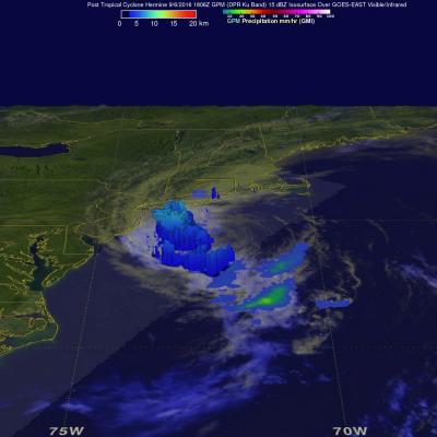
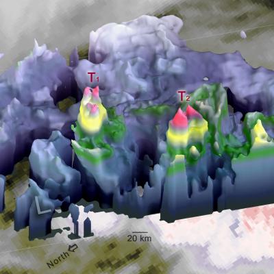
3D Precipitation Structure Within Hurricane Orlene Examined By GPM Satellite

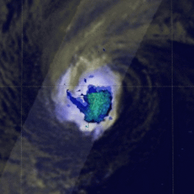
Orlene, the 9th hurricane of the 2016 eastern Pacific season has weakened to a tropical storm. The GPM core observatory satellite flew over on September 15, 2016 at 1801 UTC when Orlene was still a hurricane with winds reaching about 70 kts (81 mph). Hurricane Orlene's rainfall was examined in 3-D using data collected by the GPM satellite's Dual-Frequency Precipitation Radar (DPR). This digital "CAT scan" like view inside hurricane Orlene shows the locations of the most intense rainfall. An area of heavy downpours was uncovered near the center of Orlene's center of circulation. Radar

GPM Observes Weakening Tropical Storm Julia

Tropical storm Julia was recently downgraded to a tropical depression. The GPM core observatory satellite had an excellent view of tropical storm Julia on September 14, 2016 at 9:36 PM EDT ( September 15, 2016 0136 UTC). Julia was barely a tropical storm at that time with maximum sustained winds of about 40 mph ( 35 kts). Over the past few days Julia has dropped heavy rain along the Atlantic coastline from northeastern Florida to North Carolina. Some areas have received over 8 inches (203 inches) during the past few days. The GPM satellite measured Julia's rainfall and found that intense

GPM Takes Parting Look At Hermine

Post Tropical Cyclone Hermine was still rotating in the Atlantic Ocean east of New Jersey when the the GPM core observatory satellite flew above on September 6, 2016 at 2:05 PM EDT ( 1806 UTC). Hermine's power was greatly dissipated from the hurricane that hit Florida on September 2, 2016. Hermine still had maximum sustained winds of about 58 mph (50 kts). Hermine was also still producing some light to moderate showers. Precipitation data shown here were derived from GPM's Microwave Imager (GMI) and Dual-Frequency Precipitation Radar (DPR) instruments. Those data showed that rain was falling
NASA Sees Hermine's Twin Towers
In order for Hermine or any other tropical depression, to intensify there must be a pathway for heat energy from the ocean surface to enter the atmosphere. For Hermine, the conduit may have been one of the two "hot towers" that the Global Precipitation Measurement mission or GPM core satellite observed on Aug. 31 at 4:09 p.m. EDT (2009 UTC). GPM's DPR instrument saw strong storms near the center of Tropical Depression Hermine on the evening of Aug. 31. Two "hot towers" are seen to the right of the low pressure center (south and east of the center), which are labeled "T1" and "T2." The "L"...

GPM Sees Increasingly Organized Tropical Storm Hermine

Tropical Depression Nine was upgraded to Tropical Storm Hermine on Wednesday August 31, 2016 at 2 PM EDT (1800 UTC). The GPM core observatory satellite passed directly above newly designated tropical storm Hermine on August 31, 2016 at 4:06 PM EDT (20:06 UTC). Rainfall data derived from GPM's Microwave (GMI) and Dual-Frequency Precipitation Radar (DPR) instruments showed that precipitation intensity had increased and moved into western Florida. Rainfall measured by GPM's DPR had increased to a rate of over 9.9 inches (251 mm) per hour in very powerful storms in the Gulf Of Mexico northwest of