Extreme Weather News

Jump to a Year

2022 | 2021 | 2020 | 2019 | 2018

2017 | 2016 | 2015 | 2014 | 2013

2012 | 2011 | 2010 | 2009 | 2008

2007 | 2006 | 2005 | 2004 | 2003

2002

Tropical Disturbance Threatens India and Bangladesh

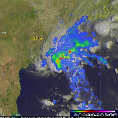
A tropical disturbance that recently formed in the Bay Of Bengal may cause heavy rainfall in the next few days along coastal India's eastern state of Odisha and southern Bangladesh. The low is predicted to move northeastward over the warm waters of the Bay Of Bengal but according to the Joint Typhoon Warning Center (JTWC) has only a medium chance of developing into a tropical cyclone. High vertical wind shear is forecast to keep the tropical disturbance from intensifying. The GPM core observatory flew above the low on November 4, 2016 at 0026 UTC. GPM saw that the low contained some strong

Deadly Storms Hit Egypt

Last week severe storms hit Upper Egypt and areas along the Red Sea coast on October 26 and 27, 2016. Egypt normally receives relatively little rain and the heaviest rainfall usually occurs along the Mediterranean coast. Heavy rainfall from intense storms led to flooding in parts of Egypt including the Sohag and Bani Suef in Upper Egypt, the Southern Sinai and the Red Sea. At least 26 deaths and 72 injuries were attributed to the storms. The GPM core observatory satellite routinely passes above that area with a very informative pass occurring on October 27, 2016 at 0541 UTC. Data collected by
Typhoon Haima Hits China After Devastating The Northern Philippines JacobAdmin Tue, 10/25/2016
After Haima's caused extensive destruction and at least 13 deaths in the northern Philippines the typhoon traveled across the South China Sea to batter Hong Kong and mainland China. Heavy rain and gusty winds accompanied Haima as the typhoon passed to the east of Hong Kong. Operations at Hong Kong's international airport were nearly stopped by the typhoon. At least one person was reported killed in Hong Kong. Haima made landfall in China 110 km (68 miles) east of Hong Kong at about 0400 UTC (noon CST). Haima's winds were decreasing and the typhoon was the equivalent of a category one hurricane

GPM Measures Extreme Rainfall With Typhoons Sarika and Haima

Two powerful typhoons have hit the Philippines in less than a week. The first was Typhoon Sarika (known as Karen in the Philippines) that formed east of the Philippines on October 12, 2016. Sarika intensified and had peak sustained winds of 115 kts (132 mph). This wind speed made it the equivalent of a category four on the Saffir-Simpson hurricane wind scale. Sarika made landfall in the Philippines on Sunday in the northern province of Aurora on the island of Luzon. Three people were killed as Sarika pounded the Philippines with heavy winds and flooding rainfall. After hitting the Philippines

GPM Looks at Rainfall in Remnants of Songda Over Pacific NW

The Global Precipitation Measurement mission or GPM core satellite saw heavy rain with rates of around 50 mm/hr (~2 inches/hr shown in dark red) in the front that absorbed the remnants of former northwestern Pacific Ocean Typhoon Songda. These images were created from data taken on Saturday, Oct. 15 as the front was affecting the U.S. Pacific Northwest. The rain is depicted in red and green areas, indicating heavy, moderate and light rain, respectively. Images produced by Jacob Reed (Telophase/NASA GSFC) and caption by Rob Gutro (GSFC)