Extreme Weather News

Jump to a Year

2022 | 2021 | 2020 | 2019 | 2018

2017 | 2016 | 2015 | 2014 | 2013

2012 | 2011 | 2010 | 2009 | 2008

2007 | 2006 | 2005 | 2004 | 2003

2002

GPM Finds Heavy Rain In Tropical Storm Ulika

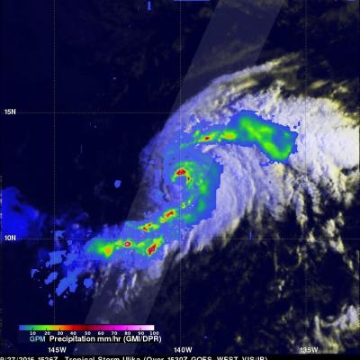
The GPM core observatory satellite had a good early morning look at newly formed tropical storm Ulika on September 27, 2016 at 5:26 AM HST (1526 UTC). Ulika was located in the central Pacific Ocean less than 975 nautical miles east-southeast of Hilo, Hawaii. GPM found that Ulika contained some very powerful convective storms and a well defined center of circulation. GPM's Dual-Frequency Precipitation Radar (DPR) discovered that some strong convective storms inside the tropical storm were dropping precipitation at a rate of over 187 mm (7.4 inches) per hour. A GPM radar slice through the center

Typhoon Megi Hits Taiwan

Three typhoons have battered Taiwan in the past few weeks. Super Typhoon MERANTI, the strongest typhoon of the year, caused havoc as it passed to the south of Taiwan on September 14, 2016. Typhoon Malakas clipped northeastern Taiwan a few days later. Typhoon Megi has now caused injuries, deaths and destruction as it passes over northeastern Taiwan. The GPM core observatory satellite passed over on September 26, 2016 at 2231 UTC when typhoon Megi was approaching Taiwan from the Philippine Sea. Megi was intensifying with maximum sustained wind speeds estimated at 100kts (115 mph). The typhoon's

GPM Views Still Energetic Tropical Depression Karl

Tropical Depression Karl's strength has fluctuated. Karl formed on September 14th in the eastern Atlantic, strengthened to tropical storm intensity on September 16th and was downgraded to a tropical depression yesterday. The GPM core observatory satellite had an outstanding view of Karl when it passed above today at 1201 UTC (8:01 AM EDT). Data collected by GPM's Microwave Imager (GMI) and Dual-Frequency Precipitation Radar (DPR) instruments uncovered heavy rainfall inside storms within the tropical depression. DPR found that powerful convective storms near Karl's center of circulation were

Remnants Of Post Tropical Storm Julia Checked By GPM

The National Hurricane Center (NHC) issued the last advisory on post tropical storm Julia on September 19, 2016 but the remnants have persisted off the Southeast coast. The remnants of the low are interacting with a slow moving frontal system and are now dropping rain over eastern North Carolina and Virginia. The GPM core observatory satellite flew over this area on Tuesday September 20, 2016 at 7:31 PM EDT (2331 UTC). The satellite's Microwave Imager (GMI) and Dual-Frequency Precipitation Radar (DPR) instruments showed the location and intensity of heavy rainfall within this area of low

GPM Sees Typhoon Malakas Starting To Batter Japan

September 19, 2016 0046 UTC September 19, 2016 1031 UTC After causing high winds and heavy rainfall over northern Taiwan, typhoon Malakas is now starting to batter the islands of southern Japan. The GPM core observatory satellite passed above typhoon Malakas twice on September 19, 2016. The first time was at 0046 UTC when the typhoon was starting to cause light to moderate rainfall over the island of Kyushu. At 1031 UTC GPM showed that moderate to heavy rainfall was moving over Kyushu and the typhoon's appearance had changed significantly. The change in appearance was credited to increased