Extreme Weather News

Jump to a Year

2022 | 2021 | 2020 | 2019 | 2018

2017 | 2016 | 2015 | 2014 | 2013

2012 | 2011 | 2010 | 2009 | 2008

2007 | 2006 | 2005 | 2004 | 2003

2002

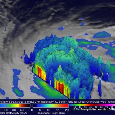
GPM Examines Upgraded Hurricane Leslie

The GPM core observatory satellite passed above hurricane Leslie on October 3, 2018 at 7:33 AM EDT (1133 UTC). Leslie had just been upgraded to a hurricane by the National Hurricane Center (NHC). GPM's Microwave Imager (GMI) instrument collected data that revealed light to moderate convective rainfall in Leslie's clearly evident eye wall. Very little precipitation was shown by GPM in the center of the hurricane's nearly circular eye. Algorithms developed by NASA's Precipitation Measurement Missions (PMM) science team indicated that rain was falling at over 1.8 inches (45.7 mm) per hour within

GPM Sees Walaka Becoming A Powerful Hurricane

The GPM core observatory recently had a couple good looks at tropical storm Walaka as it was intensifying into a powerful hurricane. GPM passed directly over tropical storm Walaka when it was located south of the Hawaiian islands on September 30, 2018 at 8:38 AM HST (1838 UTC). Data collected by GPM's Microwave Imager (GMI) and Dual-Frequency Precipitation Radar (DPR) instruments showed that Walaka was well organized and very close to hurricane intensity. GPM's Radar (DPR Ku Band) data revealed intense convective storms in a large feeder band that was wrapping around the tropical storm's

GPM View Hurricane Rosa in the Eastern Pacific

The GMI overflight here shows a clear center of circulation with much of the intense convection on the south side of Hurricane Rosa, a Category 1 storm with winds of 75 knots. It is expected to continue intensifying over the next couple days before it runs into strong shear and cooler waters off the Baja California coast. Forecasts suggest it will make landfall in Northern Baja as a tropical storm, with its primary impacts being heavy rainfall and flash flooding over the Desert Southwest.

GPM Views Cat. 2 Typhoon Trami Moving Towards Japan

View fullscreen in STORM Event Viewer Once a Category 5 Super Typhoon, Trami has become rooted in place due to a lack of steering flow. This has caused the storm to deplete the warm waters beneath it and it has since weakened to a Category 2 with maximum winds of 90 knots. It maintains a broad eye and once it begins moving again, is likely to reintensify at least somewhat as it zooms northeastward over the Ryukyu Islands and into the southern coast of Japan. Wind impacts are likely to be exacerbated by its forward speed and current forecasts expect it to have widespread impacts in a region

Super Typhoon Trami's Rainfall Examined By GPM

The GPM core observatory satellite probed super typhoon TRAMI when it traveled above the northwestern Pacific Ocean on September 24, 2018 at 1203 UTC. At that time TRAMI had maximum sustained winds estimated at 130 kts (150 mph). This image shows rainfall measurements that were made using data collected by GPM's Microwave Imager (GMI) and Dual-Frequency Precipitation Radar (DPR) instruments. GPM's GMI showed the locations of extremely heavy rainfall in the super typhoon's well defined circular eye. GPM's radar (DPR Ku Band) coverage was limited because it's swath only included storms on the