
Super Typhoon Trami's Rainfall Examined By GPM
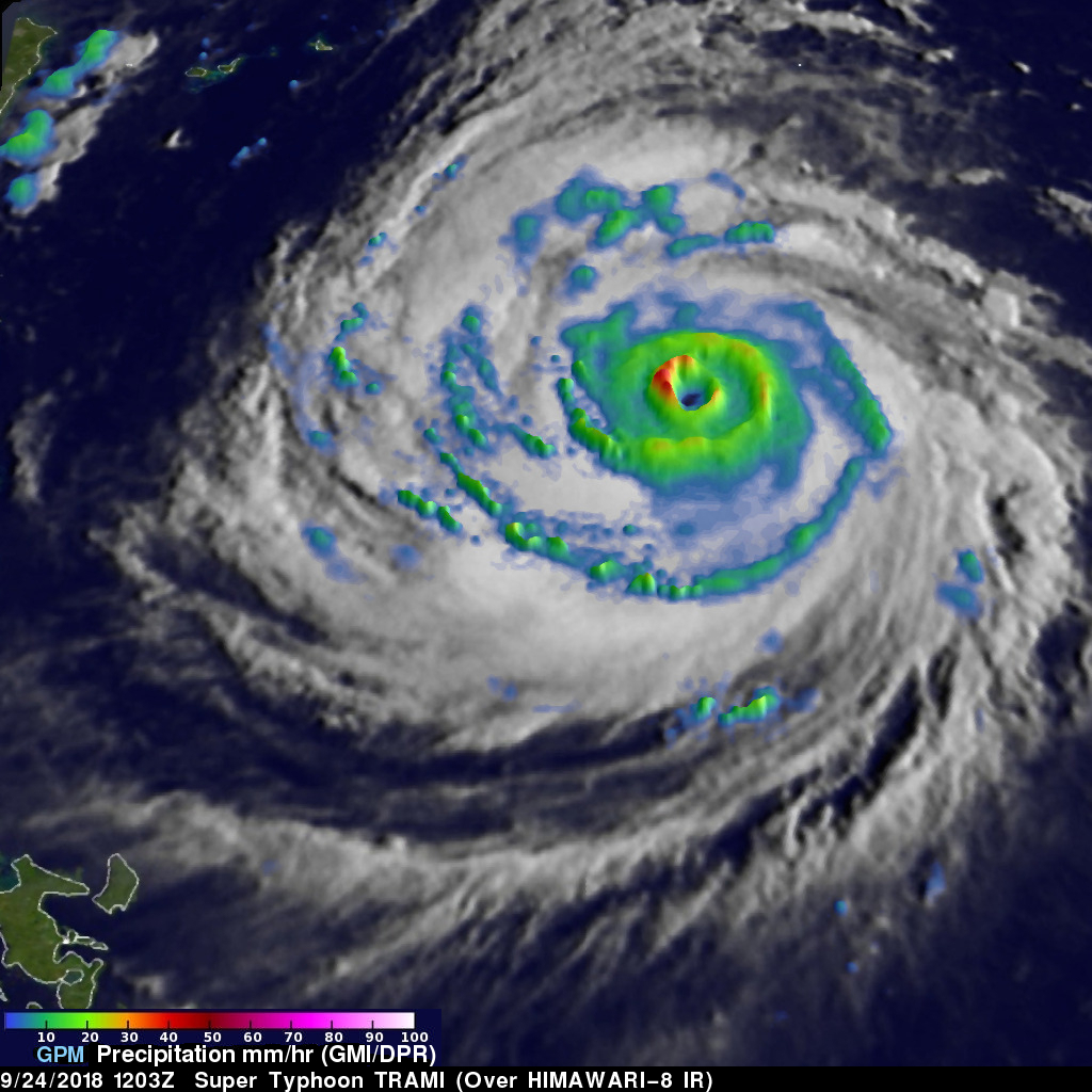
The GPM core observatory satellite probed super typhoon TRAMI when it traveled above the northwestern Pacific Ocean on September 24, 2018 at 1203 UTC. At that time TRAMI had maximum sustained winds estimated at 130 kts (150 mph). This image shows rainfall measurements that were made using data collected by GPM's Microwave Imager (GMI) and Dual-Frequency Precipitation Radar (DPR) instruments. GPM's GMI showed the locations of extremely heavy rainfall in the super typhoon's well defined circular eye. GPM's radar (DPR Ku Band) coverage was limited because it's swath only included storms on the western side of the typhoon. GPM's DPR showed that rain was falling at a rate of over 120 mm (4.7 inches) per hour within intense storms in a strong feeder band well southwest of TRAMI's eye. The Joint Typhoon Warning Center (JTWC) used this GPM pass in an evaluation of super typhoon TRAMI. JTWC's summary and analysis said that, "A 241201Z GPM 89GHZ MICROWAVE IMAGE CLEARLY REVEALS AN ONGOING EYEWALL REPLACEMENT CYCLE (ALSO INDICATED IN THE UW-CIMSS P-ERC GRAPHIC) WITH CONCENTRIC RINGS AND A MOAT FEATURE EVIDENT."
The JTWC predicts that the typhoon will travel toward the northwest and further intensify. Super Typhoon TRAMI is predicted to have maximum sustained winds of 145 kts (167 mph) on September 25, 2018. TRAMI is expected to weaken but still have winds of about 100 kts (115 mph) when it moves into the East China Sea northeast of Taiwan on September 29, 2018.
GPM is a joint mission between NASA and the Japanese space agency JAXA.