Extreme Weather News

Jump to a Year

2022 | 2021 | 2020 | 2019 | 2018

2017 | 2016 | 2015 | 2014 | 2013

2012 | 2011 | 2010 | 2009 | 2008

2007 | 2006 | 2005 | 2004 | 2003

2002

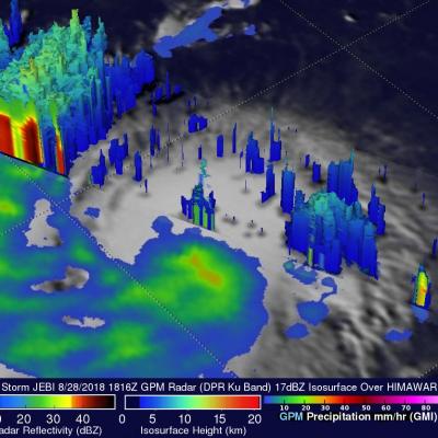
GPM Views Super Typhoon Jebi Twice

UPDATE 8/31/18 View Fullscreen in STORM Event Viewer Having peaked in intensity, Typhoon Jebi is a Category 5 Super Typhoon with maximum winds estimated around 142 knots. It is beginning an eyewall replacement cycle with a gap between the outer and inner eyewalls appearing somewhat in the DPR. The storm's strength is expected to fluctuate but remain well above Category 3 for the next two days before it turns northward toward Japan. It will likely have widespread impacts on Southern Honshu in around 4 days time, an area that has already struggled with rainfall, typhoons, and intense heat this

GPM Sees Tropical Cyclone Jebi Threaten Japan

Japan has been afflicted by several tropical cyclones and other extreme weather this summer. The Joint Typhoon Warning Center (JTWC) predicts that yet another typhoon called JEBI will be approaching the main islands of Japan early next week. Warm ocean temperatures and low vertical wind shear are providing a favorable environment for JEBI's intensification. The JTWC predicts that the typhoon will have peak sustained winds of 115 kts (132 mph) as it moves over the northern Pacific Ocean toward Japan next week. The GPM core observatory satellite passed above on August 28, 2018 at 1816 UTC when

Tropical Storm Miriam's Formation Observed by GPM

Tropical cyclone's continue to regularly develop in the eastern Pacific Ocean. Tropical Depression Fifteen-E formed in the eastern Pacific Ocean about 1000 nautical miles (1852 km) southwest of the Baja California peninsula early on Sunday August 26, 2018. TD15E became better organized with increased banding later in the day and was upgraded by the National Hurricane Center (NHC) to tropical storm MIRIAM. The GPM core observatory satellite saw the forming tropical storm earlier on August 26, 2018 at 0223 UTC. Heavy rainfall near the center of the forming tropical cyclone was examined with the

GPM Captures Cat. 4 Hurricane Lane Passing Close to Hawaiian Islands

View Fullscreen in STORM Event Viewer Battling increased vertical shear, Hurricane Lane struggles northward, down from its Category 5 peak but still featuring winds of over 110 knots. The storm has already begun impacting the Hawaiian Islands, bringing over a foot of rain to Hilo via its outer bands. Lane is expected to continue northward, approaching the island chain, before slowly veering westward as it continues to lose strength. This weakening will not diminish its likely primary impacts, which will be intense coastal erosion and damage and torrential rainfall, upwards of 30 inches in some

GPM Sees Hurricane Lane Threatening Hawaiian Islands With Heavy Rainfall

The GPM core observatory satellite flew over hurricane LANE on August 21, 2018 at 7:48 PM PST (August 22, 2018 at 0548 UTC). At that time LANE was located about 316 nautical miles (585.2 km) from Hilo, Hawaii. Hurricane LANE is one of the strongest tropical cyclones to move into the Hawaiian Islands. At the time of this GPM pass LANE was a category five on the Saffir-Simpson hurricane wind scale with winds of about 140 kts (161 mph). This analysis shows precipitation derived from data collected by the GPM satellite's Microwave Imager (GMI) and Dual-Frequency Precipitation Radar (DPR)