GPM

GPM content

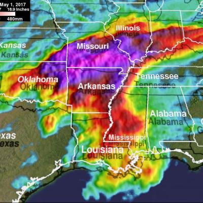
Heavy Rainfall In The Caribbean Measured By IMERG

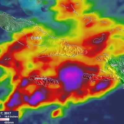
Heavy rainfall has recently caused widespread flooding and landslides in Jamaica. Occasional showers from trade winds are normal in Jamaica but recent rainfall from slow moving troughs have been unusually heavy. A 1009 mb low pressure center located in the western Caribbean was disrupting the normal trade winds over Jamaica today. This rainfall analysis was constructed using data from NASA's Integrated Multi-satelliE Retrievals for GPM (IMERG). Data collected in near-real time were utilized in IMERG's rainfall accumulation estimates for the Caribbean. This analysis covers the period from May

PPS Releases GPM V05 DPR L1-L3 and Combined L2- L3 Data

PPS is releasing GPM V05 DPR L1-L3 and Combined L2 and L3 V05 data products today, Wednesday May 17, 2017. This V05 data will be available beginning with May 01, 2017 data and forward. The DPR Level 3 monthly products will be released when validated. Reprocessed V05 DPR and Combined data for March 2014 through April 2017 will take several weeks to complete. This data will appear in PPS's arthurhou archive as we reprocess (6 to 8 weeks - estimated completion time). Registered users can obtain data from: ftp://arthurhou.pps.eosdis.nasa.gov/ and can order this through STORM: https://storm.pps

Tropical Cyclone Donna's Extreme Rainfall Evaluated With IMERG

On May 10, 2017 rapidly dissipating tropical Cyclone Donna moved to the southeast of New Caledonia in the South Pacific. In addition to being the most powerful out-of-season tropical cyclone ever recorded in the southern hemisphere, Donna also dropped extreme amounts of rainfall along it's path. Donna spread heavy rainfall along it's path from northern Vanuatu through the Loyalty Islands east of New Caledonia. Over 250mm (~10 inches) of rainfall was reported in the islands of northern Vanuatu as Donna was moving through on May 5, 2017. This rainfall analysis was constructed using data from

GPM Sees Intensifying Ella

The GPM core observatory satellite flew over intensifying tropical cyclone Ella in the South Pacific on May 10, 2017 at 2301 UTC. The satellite's Microwave Imager (GMI) and Dual-Frequency Precipitation Radar (DPR) instruments showed bands of curved rainfall bands wrapping into the center of a well defined center of circulation. GPM's DPR measured rain falling at a rate of over 231 mm (9.1 inches) per hour in an intense feeder band on Ella's eastern side. This 3-D view of tropical cyclone Ella was produced using GPM radar reflectivity data (DPR Ku Band). DPR showed that the highest storm tops

GPM Monitors Tropical Cyclone Donna

The above window displays an interactive visualization of GPM data collected from Tropical Cyclone Donna on 5/7/17. Over the weekend tropical cyclone Donna dropped very heavy rain over Vanuatu as it moved toward the west of the islands. Donna had intensified and had maximum sustained winds of 115 kts (132 mph) on Monday morning. This made it the equivalent of a category four on the Saffir-Simpson hurricane wind scale. The GPM core observatory satellite had two excellent views of the intensifying tropical cyclone Donna on succeeding days. When GPM flew over Donna on May 6, 2017 at 0146 UTC the

V04 Reprocessed Early and Late IMERG products

The GPM project has reprocessed all the original NRT IMERG data both EARLY and LATE to product version V04A. In addition, this reprocessing brought the IMERG dataset back to the beginning of the GPM mission in March 2014. The original NRT IMERG started its processing in March of 2015. Currently only the HDF5 products have been reprocessed to V04A. The TIFF/TFW versions will also be reprocessed but this will take a while longer. The V04 products are located in the directories early/YYYYMM and late/YYYYMM respectively. A subdirectory V03 has been created within those directories and the V03 data

Start of V05A NRT Swath Products

Effective approximately 04:00 UTC, 9 May 2017 the near-realtime swath products (GMI, partner constellation, radar and combined) will be upgraded from V04 to V05. During the conversion the latency of near-realtime will be affected as all the new code and support files need to be modified to carry out this upgrade. We hope this will take no more than 2 hours but can not guarantee it might not be longer. We will start with the upgrade of radar products, followed as quickly as possible by GMI and then the partner constellation products. We are starting with the radar as this requires close

Tropical Cyclone Donna's Rain Unveiled By GPM

Tropical Cyclone Donna formed in the South Pacific Ocean northeast of Vanuatu On May 2, 2017 at 1800 UTC. A few hours earlier at 1521 UTC the GPM core observatory satellite passed above that area. GPM's Microwave Imager (GMI) instrument provided a clear view of the rainfall associated with the forming tropical cyclone. GMI revealed that an intense rain band was wrapping into the center of the forming tropical cyclone from the northern side. GMI data indicated that precipitation in one of these intense rain bands was falling at a rate of over 53 mm (~2 inches) per hour. GPM's Dual-Frequency

GPM V05 Data Announcement and IMERG

The Precipitation Processing System has begun the transition to GPM Version 5 products. The satellite observations made in April 2017 will be the last observations to be included in Version 4 of the GPM data products, with one exception. Starting with observations made in May 2017, PPS will generate Version 5 GPM data products, again with one exception. The exception in both cases is that the PPS Realtime system will continue to generate the Version 4 Early and Late IMERG data products. Version 4 data products have been removed from the STORM data ordering system ( https://storm.pps.eosdis

Extreme U.S. Rainfall Analyzed With IMERG Data

Tornadoes have accompanied severe weather over the United States almost daily during the past week. Severe storms spawned tornadoes from Texas and Oklahoma eastward through Mississippi. Upper Midwest states such Illinois, Indiana and Kentucky were also visited by tornadoes. Extreme rainfall caused deadly flooding in Missouri. More than a dozen people in the Midwest and South have been reported killed by tornadoes or flooding. The same weather system is spreading severe storms through East and Northeastern states today. NASA's Integrated Multi-satelliE Retrievals for GPM (IMERG) data were used