GPM

GPM content

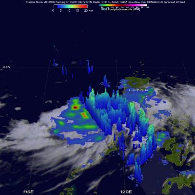
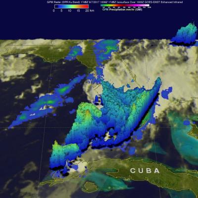
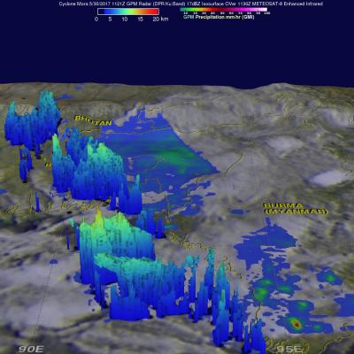
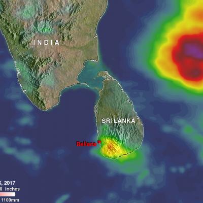
June 15 GPM NRT outage: 14:15 UTC to 15:15 UTC

Date of Event: 15 June 2017 Start Time of Event: 13:15 UTC Schedule stop time: 14:15 UTC GSFC networking personnel will be replacing network equipment that will directly impact GPM MOC, both its connection to PPS AND, more significantly, its connection to White Sands (WSC) which is the download location for GPM data. Since this replacement will provided needed increase in network throughput capacity, the update is required. During the outage, PPS SDPS (tnitta) will receive NO GPM DATA. While only an hour is currently planned for the outage as with any network modifications, changes might take

GPM Observes Tropical Storm Merbok

Tropical storm MERBOK formed in the South China Sea west of the Philippines on June 11, 2017. The GPM core observatory satellite flew above MERBOK on June 10, 2017 at 0631 UTC when the tropical storm was forming. GPM's Microwave Imager (GMI) and Dual-Frequency Precipitation Radar (DPR) showed that the future tropical storm was starting to get organized. Feeder bands were shown converging into the center of the circulation located in the South China Sea west of Luzon. GPM passed over the western side of tropical storm MERBOK again on June 12, 2017 at 0621 UTC when it's maximum sustained winds

Extreme Florida Rainfall Examined With GPM

Extremely heavy rain has recently fallen over Florida. Over 19 inches (482 mm) of rain has fallen in southeastern Florida during the past seven days. Record rainfall has been reported in Fort Lauderdale and West Palm. This extreme rainfall has led to flooding and flight cancellations. The GPM core observatory satellite flew above southern Florida on Wednesday June 7, 2017 at 6:06 AM EDT ( 1006 UTC). Data collected by GPM's Microwave Imager (GMI) and Dual-Frequency Precipitation Radar (DPR) instruments revealed the intensity of rainfall within powerful storms that were drenching southern

IMERG Shows Heavy Rainfall From Southwest India To Northeast India

In the past couple weeks rainfall has had a significant impact on Sri Lanka, southwestern India, Bangladesh and eastern India. Monsoon rainfall caused widespread flooding, devastating mudslides and displacements of many thousands of people in Sri Lanka. Over 200 people's deaths have now been attributed to this disaster. Then cyclone Mora formed in the Bay Of Bengal on May 27, 2017. Heavy rain from Mora and it's remnants moved over southeastern Bangladesh and northeastern India. Monsoon rainfall also started to move into southern India. This rainfall analysis was derived from NASA's Integrated

Status of IMERG v04 Products

In an effort to keep users informed, below is the current status of the IMERG V04 products. Summary 1. As of 02:20 UTC on 9 May 2017, IMERG Early and Late are running in V04 with backward compatibility adjustments to V05 inputs. 2. From that point to about 11:30 UTC on 12 May 2017, there are long, thin streaks of artifacts in IMERG Early and Late due to GPROF-ATMS. 3. From that point to about 15:00 UTC on 30 May 2017, there are unrealistically large areas of light rain in moist tropical ocean areas in IMERG Early and Late due to GPROF-ATMS and GPROF-MHS. Thereafter, the content of microwave

Cyclone Mora Examined By GPM

The GPM core observatory satellite passed over cyclone Mora on May 30, 2017 at 1121 UTC. Mora had passed into southeastern Bangladesh less than six hours earlier. Maximum sustained winds within Mora were estimated to be about 55 kts (63 mph) when GPM passed above. Data received by GPM's Microwave Imager (GMI) and Dual-Frequency Precipitation Radar (DPR) instruments revealed the location and intensity of rainfall around the dissipating cyclone. GPM's radar swath, shown in lighter shades, covered the area west of the dissipating cyclone's center. GPM's DPR found that rain was still falling at a

Heavy Rainfall Induced Landslide Observed By IMERG

More than 90 people have been reported killed and over 100 missing due to a landslide in the village of Bellana, in the Kalutara district of Sri Lanka. Heavy monsoon rainfall over the past few days caused the disaster. Heavy rainfall is shown over the southwestern Bay Of Bengal in this analysis of rainfall accumulation using NASA's Integrated Multi-satellitE Retrievals for GPM (IMERG) data. This IMERG analysis included the period from May 23 to early May 26, 2017. The maximum IMERG rainfall accumulation estimates in this area were shown in the Bay Of Bengal to the northeast of Sri Lanka where

Tornado Spawning Storms Examined By GPM Satellite

On Wednesday May 24, 2017 severe weather affected a large area of the eastern United States. Tornadoes were reported in Florida, Georgia, South Carolina, North Carolina and Ohio. The GPM core observatory satellite flew above a line of tornado spawning storms that were moving through the Florida panhandle on May 24, 2017 at 10:26 AM EDT ( 1426 UTC). GPM's Microwave Imager (GMI) and Dual-Frequency Precipitation Radar (DPR) instruments collected data showing that very heavy downpours were accompanying some of these storms. The violent storms moving through the Southeast were strong but GPM's

GPM Sees Powerful Storms With Advancing Monsoon

The GPM core observatory satellite passed over the Bay Of Bengal on May 23, 2017 at 0251 UTC. GPM flew almost directly above very strong convective storms that were located east of Sri Lanka. These powerful storms were associated with the approaching South-West monsoon. The amount and timing of monsoon rainfall is very important to the economy of India. GPM's Microwave Imager (GMI) and Dual-Frequency Precipitation Radar (DPR) instruments collected data that showed the location and intensity of rainfall in the southern Bay Of Bengal. Very heavy rainfall was detected within this cluster of

IMERG Sees Record Australia Rainfall

Over the past week extreme rainfall has drenched northeastern Australia. This is the heaviest rainfall in that area since tropical cyclone Debbie hit Queensland Australia in late March. Much of the recent extremely heavy rainfall was due to storms associated with a trough of low pressure slowly moving over northeastern Queensland from the Coral Sea. More than 100mm (3.9 inches) of rain in 24 hours was reported near Townsville in northern Queensland. A trough of low pressure moving eastward from central Australia has also been encroaching into western Queensland. This analysis of rainfall over