

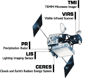
TRMM Instruments
The Tropical Rainfall Measuring Mission is the first Earth Science mission dedicated to studying tropical and subtropical rainfall: precipitation that falls within 35 degrees north and 35 degrees south of the equator. Tropical rainfall comprises more than two-thirds of the world's total. The satellite uses several instruments to detect rainfall including radar, microwave imaging, and lightning sensors. Flying at a low orbital altitude of 240 miles (400 kilometers) TRMM's data collection of tropical precipitation helps improve our understanding about climate and weather.
The Japanese space agency (JAXA) launched the satellite on an H-II rocket from Tanegashima Space Center on November 27, 1997.
Now crossing into its second operational decade, TRMM commands a historical pride of place that most other Earth science missions cannot claim. From the very beginning, this one-of-a-kind satellite and the science that goes with it is uniquely a Goddard endeavor. The most obvious expression of this is its construction. While most other research spacecraft are the direct work of designated contractors or other outside parties, civil servant engineers at NASA Goddard directed the completion and constructed the spacecraft almost entirely in-house. They also completed the integration of all the scientific instruments onboard.
Satellite Details
Launch Date: November 27, 1997
Orbit: Circular, non-sun-synchronous, with an inclination of 35 degrees to the Equator, and a precession period of about 46 days for the orbit nodes with respect to the Sun (affecting the time of day of sampling at different latitudes).
Orbit Altitude:
- 350 km +/- 6 km (11/27/1997 - 8/6/2001, prior to orbit boost)
- 403 km +/- 6 km (8/24/2001 - 7/15/2014, boost in TRMM's altitude)
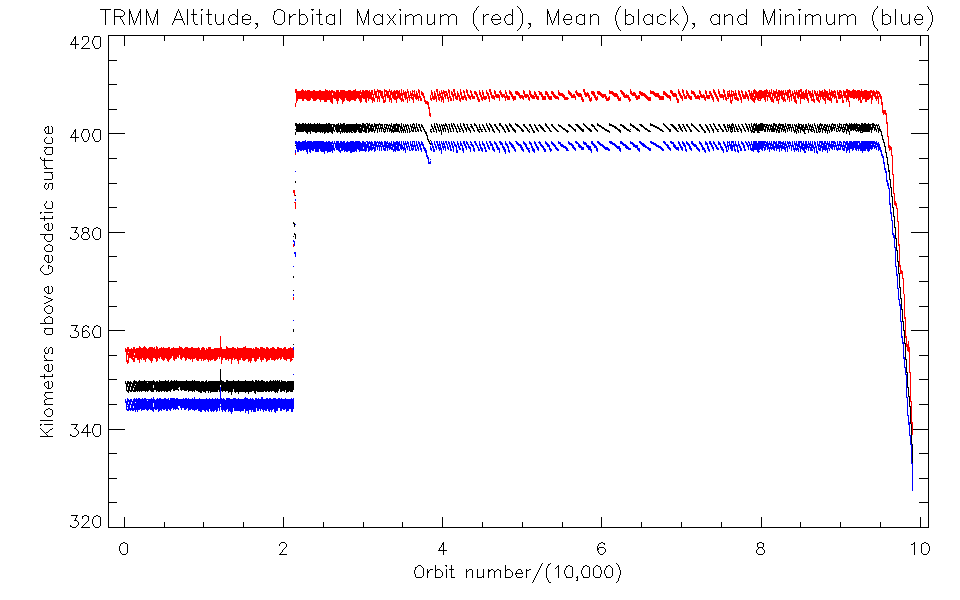
This graph shows the maximum (red), mean (black), and minimum (blue) altitude of the TRMM satellite, by orbit number, over its lifespan (11/27/1997 - 7/15/15). Credit: Stephen Bilanow, NASA Precipitation Processing System
Instruments Overview
Visible Infrared Radiometer (VIRS)
The VIRS (of NOAA AVHRR heritage) is a five-channel, cross-track scanning radiometer operating at 0.63, 1.6, 3.75, 10.8, and 12 um, which provides high resolution observations on cloud coverage, cloud type, and cloud top temperatures.
TRMM Microwave Imager (TMI)
The TMI (of DMSP SSM/I heritage) is a multichannel passive microwave radiometer operating at five frequencies: 10.65, 19.35, 37.0, and 85.5 GHz at dual polarization and 22.235 GHz at single polarization. The TMI provides information on the integrated column precipitation content, cloud liquid water, cloud ice, rain intensity, and rainfall types (e.g., stratiform or convective).
Precipitation Radar (PR)
The PR, the first of its kind in space, is an electronically scanning radar, operating at 13.8 GHz that measures the 3-D rainfall distribution over both land and ocean, and define the layer depth of the precipitation.
Cloud and Earth Radiant Energy Sensor (CERES)
CERES will measure the energy at the top of the atmosphere, as well as estimate energy levels within the atmosphere and at the Earth’s surface.
Lightning Imaging Sensor (LIS)
The Lightning Imaging Sensor is a small, highly sophisticated instrument that detects and locates lightning over the tropical region of the globe.
Instrument Specifications
| Microwave Radiometer (TMI) | Radar (PR) | Visible and Infrared Radiometer (VIRS) | |
| Frequencies | 10.7, 19.3, 21.3, 37.0, and 85.5 GHz (dual-polarized except for 21.3: vertical only) | 13.8 GHz13.8 | 0.63, 1.601.6, 3,.715.6, 1,03.8.7, 5, and 12 μm1 |
| Resolution | 11 km X 8 km field of view at 37 GHz | 5-km footprint and 250- m vertical resolution | 2.5-km resolution |
| Scanning | Conically scanning (530 inc.) | Cross-track scanning | Cross-track scanning |
| Swath Width | 880-km swath | 250-km swath | 830-km swath |