Extreme Weather News

Jump to a Year

2022 | 2021 | 2020 | 2019 | 2018

2017 | 2016 | 2015 | 2014 | 2013

2012 | 2011 | 2010 | 2009 | 2008

2007 | 2006 | 2005 | 2004 | 2003

2002

Storm Brings Heavy Precipitation to Northeast
UPDATE 1/23/2016 5:00pm ET On January 23, 2016 at 1239 UTC (7:39 AM EST) the GPM core observatory passed above the deadly winter storm that was burying the Northeast under a deep layer of snow. As GPM passed above a band of snow was shown approaching the island of Manhattan. The winter storm was predicted to dump near record snowfall in New York city. GPM's Microwave Imager (GMI) and Dual-frequency Precipitation Radar (DPR) instruments showed massive amounts of moisture being transported from the Atlantic Ocean over states from New York westward through West Virginia. GPM's Radar instruments...

Developing Tropical Cyclone Viewed By GPM

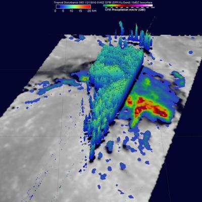
The GPM core observatory satellite saw a tropical cyclone developing in the South Indian Ocean east of Madagascar on January 21, 2016 at 0146 UTC. GPM's Microwave Imager (GMI) and Dual-frequency Precipitation Radar (DPR) measured precipitation in the potential tropical cyclone. The most intense showers were shown by the GMI instrument to be dropping rain at a rate of over 71 mm (2.8 inches) per hour in strong storms to the northeast of the tropical low's center of circulation. GPM's radar (DPR) viewed a swath of data to the west of the developing tropical cyclone center where rain was measured

Rainy Weather Over Pacific Northwest Measured From Space

Stormy weather moving in from the Pacific Ocean has frequently affected the Pacific Northwest over the past week. Moisture moving over the Washington and Oregon coasts has been transformed into snow at colder and higher elevations in the Cascades. Coincidentally a field campaign called The Olympic Mountain Experiment (OLYMPEX) is being led by NASA in the Olympic Peninsula of Washington State from November 2015 through February 2016. An analysis of precipitation that occurred in the Pacific Northwest during the period from January 12-19, 2016 is shown here. This precipitation analysis from

Alex Becomes the Earliest Hurricane to Form in the Atlantic Since 1938

Alex is a rare storm indeed. Alex officially became a hurricane yesterday at 11:00 am Atlantic Standard Time (AST) with maximum sustained winds estimated at 85 mph by the National Hurricane Center (NHC), making it the earliest hurricane to form in the Atlantic since 1938, when the first storm of the season became a hurricane on the 4th of January. As with Alex, that storm too originated from an extratropical low pressure center. The last hurricane to occur in January was Hurricane Alice in 1955, but Alice had already become a hurricane in the year before at the end of December and survived
Rainfall Floods the Mississippi River
A series of winter storms brought more than 20 inches of rainfall to the Midwest and southeastern United States in December 2015. Massive flooding followed throughout both the regions. An animation of rainfall data from those storms was created at NASA's Goddard Space Flight Center in Greenbelt, Maryland. This animation shows the accumulation of rainfall over the United Stated during December 2015, from the IMERG precipitation dataset. The black outline indicates the Mississippi-Missouri River basin. This version has been edited to only show the periods of significant rainfall during the month...