Typhoons

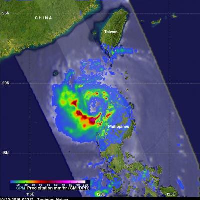
GPM Examines Deadly Typhoon Lan

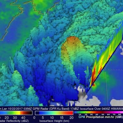
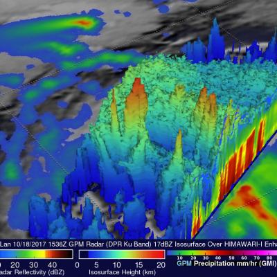
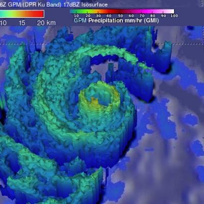
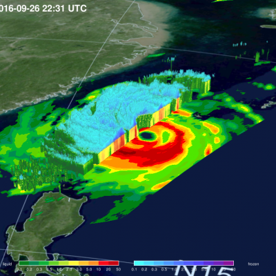
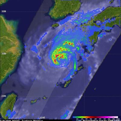
Typhoon Lan caused flooding, landslides and the death of at least seven people when it hit Japan early Monday morning. The powerful typhoon was accompanied by high winds and extremely heavy rainfall. Rain totals of 800 mm (31.5 inches) were reported in parts of south central Honshu. Wind speeds of over 106 kts (121.9 mph) were also reported. On October 22, 2017 at 0556 UTC the "core" satellite of the Global Precipitation Measurement (GPM) mission had an excellent view of Lan as the typhoon was approaching Japan. Data collected by GPM's Microwave Imager (GMI) and Dual-Frequency Precipitation

GPM Sees Intensifying Typhoon Lan Heading Toward Japan

Tropical depression twenty five (TD25W) formed in the western Pacific Ocean west of Yap on October 15, 2017. After that the intensifying tropical cyclone moved into the Philippine Sea. Tropical storm Lan recently moved toward the north and was upgraded to typhoon Lan. Maximum sustained wind speeds today (October 19, 2017) were estimated to have reached 75 kts (~86 mph). This wind speed makes it a category one on the Saffir-Simpson hurricane wind scale. Extremely warm ocean waters (30-31 degrees Celsius) along Lan's path are providing fuel for further intensification. On October 18, 2017 at

GPM Examines Typhoon Talim's Large Eye

The GPM cored observatory had another outstanding view of typhoon Talim in the western Pacific Ocean on September 13, 2017 at 1537 utc. A large eye was Talim's most distinctive feature. GPM's Microwave Imager (GMI) and Dual-Frequency Precipitation Radar (DPR) showed the location of intense rainfall within Talim's distinct eye wall. DPR revealed that rain was falling at a rate of over 232 mm (9.13 inches) per hour in convective storms in the western side of the typhoon's eye wall. GPM also showed that rainfall was far weaker to the the east of Talim's center. This dramatic 3-D view of Talim's

GPM Sees Typhoon Talim Threatening Islands Of Japan

The Joint Typhoon Warning Center (JTWC) predicts that typhoon Kalim in the western Pacific Ocean will intensify and threaten the islands of southern Japan in the the new three days. Environmental conditions such as low vertical wind shear and warm sea surface temperatures are favorable for Talim's intensification. Talim's winds are expected to increase to a peak of 115 kts as it re-curves toward the the Japanese island of Kyushu. The GPM core observatory satellite scanned the western side of typhoon Talim on September 13, 2017 at 0216 UTC. GPM's Microwave Imager (GMI) instrument collected data
Typhoon Nock-ten's Rainfall Measured By IMERG JacobAdmin Tue, 12/27/2016
Heavy rainfall and winds from super typhoon Nock-ten caused the deaths of at least six people as it roared through the Philippines. Data generated by NASA's Integrated Multi-satellitE Retrievals for GPM (IMERG) were used to estimate the total amount of rain that super typhoon Nock-ten dropped as it approached and traveled over the Philippines. Nock-ten’s approximate locations and appropriate tropical cyclone symbols at 0000Z and 1200Z are shown overlaid in white on IMERG rainfall estimate images. This IMERG analysis shows estimated rainfall totals using NASA's IMERG data produced during the

GPM Measures Extreme Rainfall With Typhoons Sarika and Haima

Two powerful typhoons have hit the Philippines in less than a week. The first was Typhoon Sarika (known as Karen in the Philippines) that formed east of the Philippines on October 12, 2016. Sarika intensified and had peak sustained winds of 115 kts (132 mph). This wind speed made it the equivalent of a category four on the Saffir-Simpson hurricane wind scale. Sarika made landfall in the Philippines on Sunday in the northern province of Aurora on the island of Luzon. Three people were killed as Sarika pounded the Philippines with heavy winds and flooding rainfall. After hitting the Philippines

Intensifying Typhoon Chaba Examined By GPM

As Typhoon Chaba moved to the western Pacific Ocean south of Okinawa over the past few days wind speeds have increased to 115 kts (132 mph).The GPM core observatory satellite flew directly above Chaba’s eye on October 2, 2016 at 2026 UTC. GPM’s Microwave Imager (GMI) and Dual-Frequency Precipitation Radar (DPR) instruments showed that Chaba was dropping extremely heavy precipitation. Some precipitation in the typhoon’s small eye wall was measured by GPM’s radar falling at a rate of more than 234 mm (9,2 inches) per hour. GPM’s Radar (DPR Ku Band) data were used to show the 3-D shape of

Typhoon Megi Hits Taiwan

Three typhoons have battered Taiwan in the past few weeks. Super Typhoon MERANTI, the strongest typhoon of the year, caused havoc as it passed to the south of Taiwan on September 14, 2016. Typhoon Malakas clipped northeastern Taiwan a few days later. Typhoon Megi has now caused injuries, deaths and destruction as it passes over northeastern Taiwan. The GPM core observatory satellite passed over on September 26, 2016 at 2231 UTC when typhoon Megi was approaching Taiwan from the Philippine Sea. Megi was intensifying with maximum sustained wind speeds estimated at 100kts (115 mph). The typhoon's

GPM Sees Typhoon Malakas Starting To Batter Japan

September 19, 2016 0046 UTC September 19, 2016 1031 UTC After causing high winds and heavy rainfall over northern Taiwan, typhoon Malakas is now starting to batter the islands of southern Japan. The GPM core observatory satellite passed above typhoon Malakas twice on September 19, 2016. The first time was at 0046 UTC when the typhoon was starting to cause light to moderate rainfall over the island of Kyushu. At 1031 UTC GPM showed that moderate to heavy rainfall was moving over Kyushu and the typhoon's appearance had changed significantly. The change in appearance was credited to increased

Typhoon Lionrock's Intensification Seen By GPM

Since August 15, 2016 Japan has been by hit by three tropical cyclones called Mindulle, Chantu and Kompasu. Tropical cyclone Lionrock may be the next to affect Japan. Lionrock formed east of Japan on August 18, 2016 and passed by to the south of Japan as a tropical storm. Loinrock then interacted with tropical storm Mindulle which spun by to the east. Mindulle, although somewhat weakened by Lionrock's outflow, hit Tokyo killing at least 2 people. Lionrock then moved to the southeast of Okinawa and became a powerful typhoon. The GPM core observatory satellite recently passed over typhoon