TRMM News

Cyclone Nathan Circles Back JacobAdmin Wed, 03/18/2015
Cyclone Nathan located in the Coral Sea off Australia's Queensland coast has made another loop and is again headed slowly toward the Cape York Peninsula. Rainfall derived from the TRMM satellite's Microwave Imager (TMI) and Precipitation Radar (PR) instruments is shown with data collected on March 18, 2015 at 0758 UTC. The heaviest rainfall was measured by TRMM PR falling at a rate of over 119 mm (4.7 inches) on the eastern side of Nathan's eye. TRMM PR data were used in this 3-D view of cyclone Nathan. Storm heights in a rain band circling Nathan's northwestern side were found reaching
Cyclone Pam Departs Vanuatu JacobAdmin Tue, 03/17/2015
As one of the strongest cyclones every recorded in the South Pacific, Cyclone Pam devastated the island archipelago of Vanuatu. As the cyclone bore down on Vanuatu's central islands on the afternoon (local time) of March 13th, Pam's maximum sustained winds were estimated to have increased to 270 kph (~167 mph) by the US Joint Typhoon Warning Center (JTWC), making it a category 5 storm on the US Saffir-Simpson scale. The storm caused immense, widespread damage with the islands of Erromango and Tanna suffering a direct hit. Although damage is still being assessed, the number of reported

Tropical Cyclone Eunice

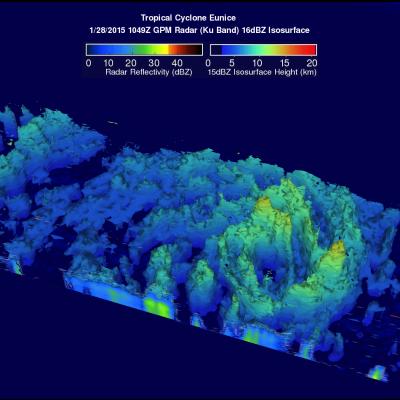
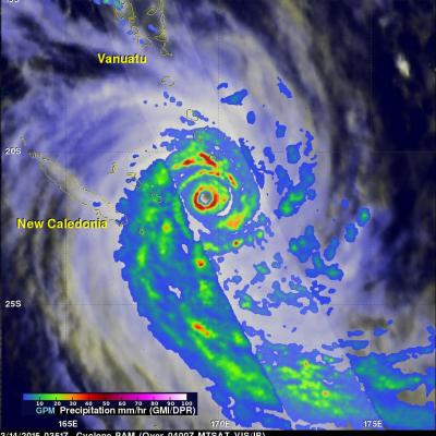
Tropical cyclone Eunice became the fourth tropical cyclone of the 2015 Southern Indian Ocean season when it formed well east of Madagascar on January 27, 2014. Maximum sustained winds within the tropical cyclone have increased to about 85kts (~98 mph) and Eunice is predicted by the Joint Typhoon Warning Center (JTWC) to continue becoming more powerful as it travels toward the southeast. The GPM (core satellite) flew directly over the eye of newly formed tropical cyclone on January 28, 2015 at 1049 UTC. GPM's Microwave Imager (GMI) found that rain was falling at a rate of only 30.2 mm (about 1

Mekkhala Becomes A Typhoon, Drenches The Philippines

On January 16, 2015 tropical storm Mekkhala became the first western Pacific typhoon of the year just before hitting the eastern Philippines. This image shows rainfall derived from data captured by the GPM (core satellite) on January 16, 2015 at 2200 UTC. This was only about four hours after Mekkhala was upgraded to a typhoon. GPM's Microwave Imager (GMI) found rain falling at a rate of over 70.7 mm (about 2.8 inches) per hour in storms southwest of the typhoon's eye. Rainfall over the Philippines, enhanced by typhoon Mekkhala, was analyzed using near real time merged satellite data (3B42)

Southwest Indian Ocean Has Two Tropical Cyclones

As tropical storm Mekkhala approaches the Philippines in the northern hemisphere tropical cyclone activity in the southeast Indian ocean has recently increased. The TRMM satellite has been monitoring rainfall in the tropics since 1997. On February 15, 2015 the TRMM satellite flew over two tropical cyclones in successive orbits. BANSI 1/15/2015 1308Z CHEDZA 1/15/2015 1440Z Rainfall derived from TRMM's Microwave Imager (TMI) is shown overlaid on a METEOSAT-7 Visble/Infrared images. On January 15, 2015 at 1308 UTC the satellite saw powerful category four tropical cyclone Bansi northeast of the

Tropical Depression Mekkhala Organizes

Tropical Depression 01W, in the western Pacific Ocean, has been given the name Mekkhala. The tropical cyclone has become much better organized and the Joint Typhoon Warning Center (JTWC) predicts that tropical storm Mekkhala will affect the eastern Philippines in a few days. The GPM (core satellite) flew above Mekkhala on January 14, 2015 at 1043 UTC. GPM's Microwave Imager (GMI) instrument observed rain falling at a rate of over 71.63 mm (about 2.8 inches) per hour in intense convective storms near the tropical cyclone's center. This 3-D view was derived from data collected by GPM's Radar (Ku

Two Satellites Measured Rainfall in Tropical Depression Mekkhala

The first tropical depression of the 2015 western Pacific season formed southwest of Guam on January 13 and is predicted to intensify into a tropical storm while headed toward the Philippines. NASA's TRMM and GPM satellites provided a look at Tropical Depression Mekkhala's rainfall data that showed the area of moderate rainfall had expanded as the storm strengthened on January 13. Mekkhala was previously known as Tropical Depression 01W until January 14 when it was renamed. Both the Global Precipitation Measurement (GPM) core satellite and the Tropical Rainfall Measuring Mission (TRMM)

Deadly Flooding and Landslides With Tropical Storm Jangmi

Jangmi became the 23rd named tropical cyclone in the western Pacific Ocean when it formed southeast of the Philippines on December 28, 2014. Heavy rainfall from Tropical storm Jangmi recently produced flooding and landslides in the Philippines that have reportedly killed over 30 people. The Philippines frequently gets hit by tropical cyclones. Tropical storm Jangmi hit only three weeks after slow moving typhoon Hagiput churned through the central Philippines. The TRMM satellite had a fairly good view of Jangmi on December 29, 2014 at 1425 UTC. The TRMM Microwave Imager(TMI) instrument showed

California's Drought Improving

Waves of rainfall from Pacific Ocean storms show signs of improving the exceptional drought conditions that have been plaguing California. Starting on about November 30, 2014 storms frequently moved over California. A Multi-satellite Precipitation Analysis (MPA) using data (3B42) archived at near "real time" at the NASA Goddard Space Flight Center was used in the analysis. It indicates that northern California has had far more beneficial rainfall than southern California. This analysis shows that storms dropped over 350mm (almost 14 inches) in an area north of San Francisco. Southern

"Pineapple Express" Brings Heavy Rains, Flooding to U.S. West Coast

The West Coast, which has been suffering from a strong drought, is finally seeing some much needed relief as a steady stream of storms and rain pour into the coast from the Pacific. The rains began in Washington and Oregon and have now worked their way down the coast to southern California. The weather pattern responsible for all of the rain is known as the "Pineapple Express." The Pineapple Express is known as an atmospheric river. A large, slow-moving low pressure center off of the West Coast taps into tropical moisture originating around the Hawaiian Islands, which is then channeled