TRMM News

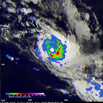
GPM Measures Rain in Cyclone Joalane

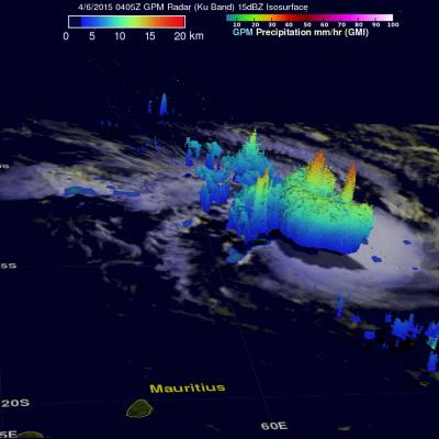
Two powerful tropical cyclones called Ikola and Joalane are now moving through the South Indian Ocean. The GPM core observatory satellite flew over intensifying cyclone Joalane in the South Indian Ocean on April 6, 2015 at 0406 UTC. GPM's Microwave Imager(GMI) found that intense convective thunderstorms within Joalane were dropping rain at a rate of over 63 mm (2.5 inches) per hour. Cyclone Joalane was located northeast of Mauritius at the time of this GPM pass. A 3-D view of Joalane's vertical precipitation structure was constructed from GPM's Radar (Ku Band) data. This cross section shows

Cyclone Ikola

The TRMM satellite's Microwave Imager (TMI) instrument collected data used in this rainfall analysis when the satellite flew over tropical storm Ikola in the South Indian Ocean on April 5, 2015 at 1722 UTC. TMI data revealed the location of rain falling at a rate of over 50 mm (amost 2 inches) per hour around Ikola's eye.

GPM Saw Deadly Maysak Approaching The Philippines

Typhoon Maysak caused the reported deaths five people in the Federated States of Micronesia and as a tropical storm killed seven others when it hit the the north-eastern Philippines. The GPM core observatory satellite passed above dissipating typhoon Maysak when it was approaching the Philippines on April 3, 2015 at 2326 UTC. An analysis of rainfall from GPM's Microwave Imager (GMI) showed that Maysak was dropping rain at a rate of over 69 mm (2.7 inches) per hour. Vertical wind shear was causing typhoon Maysak to weaken as it moved toward the Philippines but data from GPM's Dual-Frequency

Tropical Depression Five Forms

As typhoon Maysak heads toward the Philippines yet another tropical cyclone was born today in the the Pacific Ocean west of Pohnpei. The GPM core observatory satellite had a good view of tropical depression five on April 3, 2015 at 1031 UTC. GPM's Microwave Imager (GMI) found that rain was dropping at a rate of 22.4 mm (.9 inches) per hour in bands of convective storms located northwest of the center of circulation. The 3-D view from GPM's Dual-Frequency Precipitation Radar (Ku Band) shows that some of these storms were reaching heights of over 14.7 km (9.1 miles).

Typhoon Maysak Starts Weakening

The GPM core observatory satellite passed above typhoon Maysak in the western Pacific Ocean on April 2, 2015 at 2343 UTC. GPM's Microwave Imager (GMI) found heavy rain in Maysak's northwestern side but the typhoon had weakened from it's peak intensity of over 130 kts (150 mph) to about 115 kts (132 kts) at the time of this satellite view. GPM's Radar (Ku Band) was used in this 3-D view to show vertical structure within typhoon Maysak. This view, looking toward the southwestern side of Maysak's eye, shows that the eye wall was eroding on that side. Vertical wind shear has contributed to typhoon

TRMM Satellite Makes Direct Pass over Super Typhoon Maysak

The Tropical Rainfall Measuring Mission satellite delivered a remarkable image of Super Typhoon Maysak on March 31. TRMM obtained an image straight over the top of a super typhoon with a double eye-wall, Super Typhoon Maysak, as it roared through the warm waters of the West Pacific south of Guam. This image with the TRMM Precipitation Radar or PR was taken at 14:15 UTC (10:15 a.m. EDT) on March 31, 2015 and shows the rain intensities within the very heart of Super Typhoon Maysak as it undergoes an eye wall replacement cycle. Mature, intense tropical cyclones can and often do undergo what is

TRMM And GPM See Typhoon Maysak

The TRMM satellite has been collecting valuable scientific data since November 1997. Early today the satellite collected rainfall data from recently formed typhoon Maysak as it flew directly above on March 30, 2015 at 0414 UTC. This image shows rainfall data collected with this orbit by TRMM's Microwave Imager (TMI) and Precipitation Radar (PR) instruments. With sustained winds of over 85 kts (98 mph) Maysak was a category two typhoon on the Saffir-Simpson hurricane wind scale. A little over eight hours later the GPM core observatory satellite also viewed typhoon Maysak on March 30, 2015 at

Tornadoes Hit Southwest

Seven Tornadoes were reported yesterday in a line of violent thunderstorms extending over Oklahoma and Arkansas. One death was reported in a tornado that hit near Tulsa, Oklahoma. The TRMM satellite flew over this line of deadly storms on March 25, 2015 at 11:21 CDT ( March 26, 2015 at 0321 UTC). The first image shows a rainfall analysis that was formed from data collected by TRMM's Microwave Imager (TMI) and Precipitation Radar (PR) instruments at the time of this pass. TRMM PR data indicated that rain was falling at the extreme rate of over 172 mm (6.8 inches) per hour in some powerful

Cyclone Nathan Dissipates

The GPM core observatory satellite saw dissipating cyclone Nathan when it flew over Australia's Top End on March 24, 2015 at 0256 UTC. Nathan was shown dropping light to moderate rain after being cut off from moisture flowing from the Arafura Sea and the Gulf Of Carpentaria. The Joint Typhoon Warning Center (JTWC) predicts that Nathan will continue to weaken for the next few days while traveling westward over land.

GPM And TRMM See Glenda At Same Time

Tropical storm GLENDA formed over the open waters of the South Indian Ocean southeast of Diago Garcia on February 24, 2015. GLENDA didn't get above tropical tropical storm intensity and has not posed a significant threat to islands in the area. An interesting event occurred on February 25, 2015 when both the TRMM satellite and it's successor the GPM core observatory satellite passed over the tropical cyclone at almost the same time. This 3-D view was constructed from GPM Radar data (Ku Band) collected with the 1521 UTC pass. It shows the vertical structure of tropical storm GLENDA along the