TRMM News

Deadly Super Typhoon Hagupit Moved Slowly

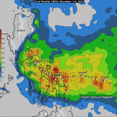
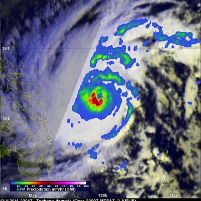
As of Today, super typhoon Hagupit has been deadly with up to 27 deaths reported but the Philippines has been spared the widespread destruction caused by Super typhoon Haiyan in 2013. Hagupit's (called Ruby in the Philippines) forward motion slowed on December 4, 2014 before reaching the Philippines. After hitting Samar in the eastern Philippines Hagupit's continued slow movement resulted in high rainfall amounts along the typhoon's track. These high rainfall totals meant that flooding occurred frequently along the typhoon's track. When the TRMM satellite flew over on December 8, 2014 at 0132

GPM Core Observatory Sees Hagupit's Eye

The GPM satellite flew almost directly above dangerous typhoon Hagupit on December 5, 2014 at 1032 UTC as the typhoon was approaching the Philippines. The GPM Microwave Imager (GMI) instrument measured rain falling at a rate of over 76 mm (almost 3 inches) per hour in the typhoon's eye wall. This 3-D view of Hagupit's precipitation structure was made using data from the Ku band on GPM's dual frequency radar instrument (DPR). DPR showed that some tall thunderstorm in Hagiput's eye wall were reaching heights of almost 15 km (about 9.3 miles). Click here to see a Low Resolution 640x360 simulated

Super Typhoon Hagupit Threatens Philippines

Super Typhoon Hagupit is threatening the Philippines a little over a year after deadly Super Typhoon Haiyan devastated the island nation in November 2013. Hagupit was weakening slightly from peak wind speeds of 155 kts (178 mph) when the GPM core observatory satellite passed over on December 4, 2014 at 2304 UTC in the image shown above. Hagupit had winds of about 125 kts (144 mph) when viewed by the TRMM satellite on December 5, 2014 at 0308 UTC in the image shown below. Rainfall data from these satellites are shown overlaid on daylight views from the MTSAT-2 satellite captured at close to the

California's Rainfall Analyzed From Space

It has been very dry in the state of California for the past couple years. The lack of rain in 2013 and 2014 contributed to exceptional drought conditions in the state. Records were set over the past winter for the lowest winter snow packs recorded in a century. Rainfall produced by storms moving into California from the Pacific Ocean has recently brought some very temporary drought relief. Precipitation data (3B42) from various satellites such as TRMM and recently the GPM core observatory satellite have been collected, merged and archived at the Goddard Space Flight Center since 1998. The

TRMM And GPM Core Satellite See Sinlaku Headed Toward Vietnam

Tropical storm Sinlaku formed on November 26, 2014 over the southeastern Philippines. As a tropical depression Sinlaku caused flooding in areas of the Visayas and Mindanao. The TRMM and the GPM core satellite viewed Sinlaku after it had strengthened into a tropical storm over the South China Sea. The first image shows rainfall derived from TRMM Microwave Imager (TMI) data collected when the satellite flew over on November 28, 2014 at 0716 UTC. The second view shows rainfall from GPM Microwave Imager (GMI) measurements received a little over six hours later at 1326 UTC. Rainfall was measured by

GPM Measures Rainfall In Tropical Storm Adjali

Moderate rainfall was occurring around the center of Tropical Storm Adjali before it dissipated, according to data from NASA and the Japan Aerospace Exploration Agency's Global Precipitation Measurement or GPM satellites. Adjali became the first named storm of the Southwest Indian Ocean 2014/2015 cyclone season when it formed on November 16, 2014. Adjali became a strong tropical storm the next day and just two days later started to dissipate. The GPM observatory captured data on Adjali's rainfall rates on Nov. 18. GPM's Microwave Imager (GMI) instrument is similar to the Tropical Rainfall

Hurricane Vance Weakening, Heading Toward Mexico

The TRMM satellite flew over hurricane Vance on November 2014 at 0953 UTC. Rainfall derived from TRMM's Microwave Imager (TMI) data collected with that view are shown overlaid on a 1000 UTC GOES-WEST image. This analysis showed that Vance had a large area of heavy rainfall near the center of the hurricane. Some intense storms in that area were dropping rain at a rate of over 50mm/hr (almost 2 inches) per hour. Vance's power peaked late on November 3, 2014 with winds of about 95 kts (about 109 mph). Vertical wind shear had started to weaken the hurricane at the time of this view but Vance was

Tropical Storm Vance Forms

The hurricane season continues to be active in the eastern Pacific Ocean. A Tropical depression south of southern Mexico was upgraded to tropical storm Vance yesterday. The National Hurricane Center (NHC) predicts that Vance will become a hurricane Sunday morning making it the sixteenth hurricane of the 2014 eastern Pacific Ocean hurricane season. TRMM's Microwave imager (TMI) had a good view of the rainfall around tropical storm Vance on October 31, 2014 at 0234 UTC. An analysis of this rainfall is shown overlaid on a 0245 UTC GOES-EAST enhanced infrared image. Intense convective

Tropical Storm Ana Still Vigorous

The TRMM satellite flew over tropical storm ANA on October 22, 2014 at 1935 UTC (about 8:30 AM local time). ANA formed over ten days ago but after moving to the northwest of the Hawaiian islands the tropical storm was shown to be still vigorous. A rainfall analysis from TRMM's Microwave Imager (TMI) revealed an area near ANA's center of circulation where rain was falling at a rate of over 40 mm (about 1.6 inches) per hour. The Joint Typhoon Warning Center (JTWC) predicts that ANA will maintain tropical storm intensity for the next five days while moving over open waters toward the northwest.

Hurricane Ana Bypasses But Soaks Hawaiian Islands

Fortunately for Hawaii hurricane Ana passed to the south of the islands. This meant that for the third time this year the Hawaiian Islands were spared destructive hurricane force winds. However, Ana caused occasionally heavy rain over much of the area and was responsible for flash floods on the the big island (Hawaii). This analysis shows estimated rainfall totals during the period when hurricane Ana formed on October 13, 2014 and moved west of the Hawaiian Islands on October 21, 2014. The TRMM-based, near-real time Multi-satellite Precipitation data (TMPA) analysis is used to monitor rainfall