Hal Pierce

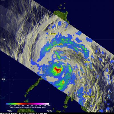
Haiyan and Tropical Storm 30 Bring Heavy Rains to the Philippines

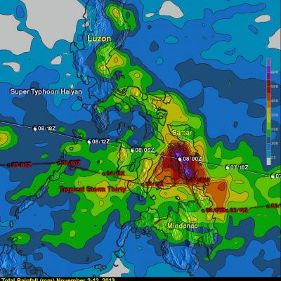
Super typhoon Haiyan, known locally in the Philippines as Yulonda, will go down as a historic storm, making landfall in the central Philippines as perhaps the most powerful tropical cyclone to ever make landfall with sustained winds estimated at 195 mph (~315 kph). So far, over 2300 people are confirmed to have been killed by the storm, and the number is likely to climb higher with many still missing and not all areas unaccounted for. Katrina, which devasted the US Gulf coast in 2005, was responsible for 1833 fatalities The most deadly flooding from Super Typhoon Haiyan was caused by the storm
Super Typhoon Haiyan Hits the Philippines
Super typhoon Haiyan, equivalent to a Category 5 hurricane on the US Saffir-Simpson scale, struck the central Philippines municipality of Guiuan at the southern tip of the province of Eastern Samar early Friday morning at 20:45 UTC (4:45 am local time) as an extremely powerful super typhoon, perhaps the strongest ever recorded at landfall, with sustained winds estimated at 195 mph (315 kph) by the Joint Typhoon Warning Center. Previously, Hurricane Camille, which struck the northern Gulf Coast in 1969, held the record with 190 mph sustained winds at landfall. After striking Samar, Haiyan...

Super Typhoon Haiyan Moving Toward The Philippines

As predicted by the Joint Typhoon Warning Center (JTWC) typhoon Haiyan became a powerful category five typhoon with sustained winds estimated to be over 135kts (~155 mph). Super typhoon Haiyan is predicted to strike the central Philippines in a few days. Super typhoon Haiyan was located just northeast of Palau when the TRMM satellite flew above on November 6, 2013 at 1026 UTC. A rainfall analysis from TRMM's Microwave Imager (TMI) and Precipitation Radar (PR) instruments is shown overlaid on an enhanced infrared image from TRMM's Visible and InfraRed Scanner (VIRS). Data from TRMM's TMI and PR

Typhoon Haiyan (31w) Develops East Of The Philippines

The Joint Typhoon Warning Center (JTWC) predicts that typhoon HAIYAN (31W) that developed east of the Philippines will become dangerous super typhoon HAIYAN with winds of 130kts (~150mph) before it hits the southern Philippines in about three days. The TRMM satellite had a good daytime view when it flew above tropical storm HAIYAN (31W) yesterday evening on November 4, 2013 at 2353 UTC. This image shows precipitation data collected with TRMM's Microwave Imager (TMI) and Precipitation Radar (PR) instruments overlaid on a combination visible and infrared image from TRMM's Visible and InfraRed

TRMM Has Second Look At Typhoon Krosa

On November 1, 2013 at 1320 UTC the TRMM satellite had the second look at typhoon KROSA. KROSA weakened slightly when it passed over the northern Philippines but had started to intensify with this second pass over the South China Sea. The image on the left shows rainfall data collected by TRMM's Microwave Imager (TMI) and Precipitation Radar (PR) instruments overlaid on an enhanced infrared image. TRMM PR data revealed that rain was falling at a rate of over 116mm/hr (4.5 inches) in KROSA's eye wall. Radar reflectivity values greater than 50dBZ were found in the same area. The 3-D perspective

Tropical Storm Raymond Fading Fast

There has been some recent convective activity within tropical storm Raymond but southwesterly wind shear and cooler ocean temperatures are predicted by the National Hurricane Center (NHC) to weaken the tropical storm to a remnant low on Wednesday October 30, 2013. Raymond contained rainfall only in an area northwest of it's center of circulation when the TRMM satellite passed above on October 28, 2013 at 2337 UTC (4:37 PM PDT). Rainfall data from TRMM's Microwave Imager (TMI) and Precipitation Radar (PR) are shown overlaid on a combination visible and infrared image from TRMM's Visible and

TRMM Sees Two Pacific Tropical Cyclones

Tropical Storm Lekima Tropical Storm Francisco The TRMM satellite flew above the centers of two tropical cyclones in the western Pacific Ocean early this morning. The first orbit saw super typhoon LEKIMA at 0745 UTC and with the next orbit tropical storm FRANCISCO came into view at 0919 UTC. Lekima was located southeast of tropical storm Francisco over the open waters of the Pacific. Precipitation data from TRMM's Microwave Imager (TMI) and Precipitation Radar (PR) instuments are shown overlaid on infrared images from TRMM's Visible and InfraRed Scanner (VIRS). These rainfall analyses show the

Hurricane Raymond's Copious Rainfall Analyzed

Powerful hurricane Raymond, located off Mexico's south-central Pacific coast, has weakened to a tropical storm. It has now started to move slowly away from the location where it has been parked since Monday October 21, 2013. Raymond dropped abundant rainfall in much of the same area already hit by deadly flooding and landslides with Hurricane Manuel last month. The rainfall analysis above was made at Goddard Space Flight Center using TRMM-based, near-real time Multi-satellite Precipitation data (TMPA) collected during the period from October 15 to 23, 2013. Rainfall totals greater than 125mm (

Weaker Typhoon Francisco Seen By TRMM

Typhoon Francisco was headed toward the islands of southern Japan when the TRMM satellite had a good view on October 22, 2013 at 0933 UTC. Francisco was weakening and had estimated winds of less than 75kts (~86 mph) with this TRMM pass. An analysis derived from TRMM's Microwave Imager (TMI) and Precipitation Radar (PR) instruments is shown overlaid on an enhanced infrared image from TRMM's Visible and InfraRed Scanner (VIRS). This analysis showed that the most intense rain was falling at a rate of over 75mm/hr (~3 inches) in a location well to the southwest of Francisco's center of circulation

Hurricane Raymond Soaking Mexican Coast

A month ago hurricane Manuel caused caused landslides and extensive flooding along Mexico's Pacific Ocean coast. Recently formed hurricane Raymond is expected to cause heavy rainfall in nearly the same area. The TRMM satellite flew directly above hurricane Raymond on October 21, 2013 at 0111 UTC (October 20 at 6:11 PM PDT). TRMM Precipitation Radar (PR) data from that orbit shows that hurricane Raymond contained towering thunderstorms on the western side of the eye wall that were reaching to heights above 15km (~9.3 miles). TRMM PR also recorded precipitation in Raymonds eye wall that was