Hal Pierce

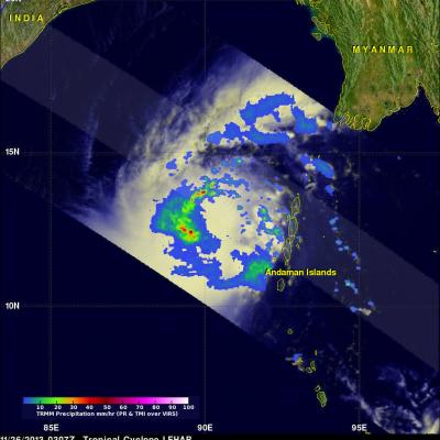
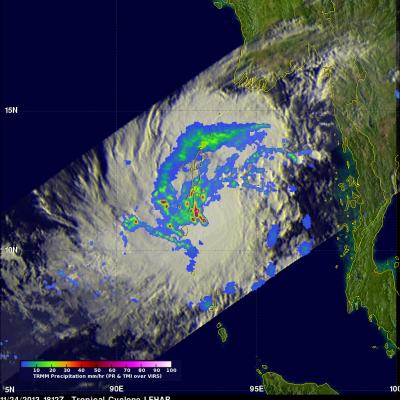
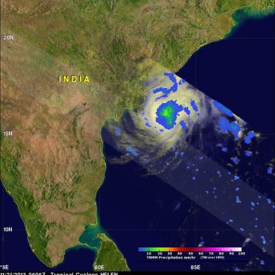
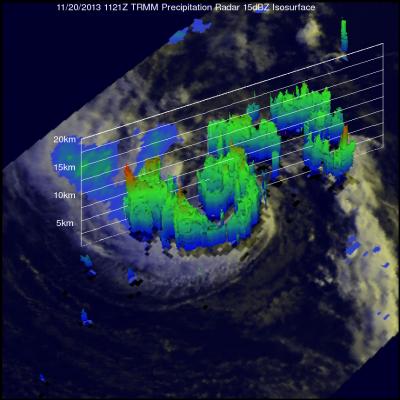
Tropical Cyclone Christine

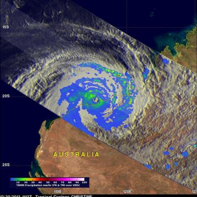
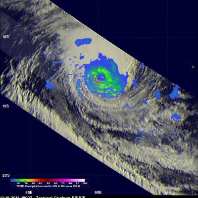
Tropical cyclone Christine was in the South Indian Ocean close to the northwestern coast of Australia when the TRMM satellite passed over on December 30, 2013 at 1113 UTC. TRMM's Microwave Imager (TMI) and precipitation Radar (PR) instruments revealed that Christine had a well defined eye. TRMM PR found that the most intense rain was falling at a rate of over 70mm/hr (~2.8 inches) in intense bands well to the east of Christine's eye. TRMM's Microwave Imager (TMI) instrument provided good coverage of Christine's eye while TRMM's Precipitation Radar (PR) had a good look at Christine's

Intensifying Tropical Cyclone Bruce

A powerful tropical cyclone called Bruce formed quickly after tropical cyclone Amara in the south Indian Ocean. Intensifying Tropical cyclone Bruce had winds of over 90kts (~103.5 mph) When the TRMM satellite passed over head on December 19, 2013 at 1800 UTC. A rainfall analysis from TRMM's Microwave Imager (TMI) and Precipitation Radar (PR) instruments is shown on the left overlaid on an enhanced infrared image from TRMM's Visible and InfraRed Scanner (VIRS). Bruce was found to have a well defined eye with rain falling at a rate of over 115 mm/hr (~4.5 inches). TRMM PR sliced through the

TRMM Sees Tropical Cyclone Amara Forming

Yesterday Amara became the third tropical cyclone since October 2013 to form in the South Indian Ocean. TRMM Microwave Imager (TMI) and Precipitation Radar (PR) data captured by the TRMM satellite on December 16, 2013 at 2043 UTC were used in the image on the upper left. TRMM's Microwave Imager (TMI) and Precipitation Radar (PR) instruments showed that Amara was getting organized with scattered bands of moderate to heavy rain spiraling into the tropical cyclone's center. TRMM PR located some strong radar reflectivity values of over 47.7 dBZ in rain falling at a rate of over 76.9 mm/hr (~3

Philippine's Tropical Cyclone Rainfall 2013

In a normal year 30% of the total rainfall near the Philippines (northwestern Pacific Ocean) is caused by tropical cyclones. The most notable tropical cyclone this year was deadly super typhoon HAIYAN that devastated the central Philippines in November 2013. The TRMM-based, near-real time Multi-satellite Precipitation Analysis (TMPA) at the NASA Goddard Space Flight Center was used to analyze only rainfall near tropical cyclones passing close to or over the the Philippines in 2013. The TMPA analysis above shows the estimated total rainfall contributed by named tropical cyclones this year. Red

Tropical Cyclone Alessia Soaks Northern Australia

During the past weekend tropical cyclone ALESSIA weakened to a tropical low as it moved from the Timor Sea over Northern Australia. The warm waters of the Gulf Of Capentaria have helped revive ALESSIA to tropical storm intensity today. The image on the right shows TRMM satellite data collected on November 27, 2013 at 0225 UTC. A 3-D perspective view (from the west) shows the tropical cyclone's vertical structure based on radar reflectivity data collected by TRMM's Precipitation Radar (PR) instrument. Thunderstorm towers are shown reaching heights above 16km (~9.92 miles) in a feeder band east

Tropical Cyclone Lehar Moving Toward India

Tropical cyclone LEHAR, located in the Bay Of Bengal, continues to gain intensity while heading toward the same area of India where a much weaker tropical cyclone HELEN recently came ashore. The Joint Typhoon Warning Center (JTWC) predicts that LEHAR's sustained wind speeds will reach 95 kts (~109 mph) on November 27, 2013 and then decrease to about 85 kts (~98 mph) before hitting India's east-central coast. The TRMM satellite flew above tropical cyclone LEHAR on November 26, 2013 at 0307 UTC and captured data used in the image above. Rainfall derived from TRMM's Microwave Imager (TMI) and

Tropical Cyclone Lehar In The Bay Of Bengal

Today tropical cyclone LEHAR's estimated sustained wind speeds reached 65kts (~75 mph). The most powerful tropical cyclone in the Bay Of Bengal this year was deadly tropical cyclone PHAILIN that moved through the area in October with wind speeds of 140kts (~161 mph). This means that LEHAR is the second most powerful tropical cyclone to form in the Bay Of Bengal this year. The TRMM satellite collected data used in the image on the left when the TRMM satellite passed above LEHAR on November 24, 2013 at 1812 UTC. At that time LEHAR was intensifying with tropical storm force winds estimated to be

Tropical Cyclone Helen Hits India

Tropical cyclone Helen was the fourth named tropical cyclone in the Bay Of Bengal this year when it formed on November 19, 2013. The image on the left shows tropical cyclone Helen as the TRMM satellite flew over on November 21, 2013 at 0606 UTC when Helen had reached peak intensity of about 60kts (~69 mph). The image on the right uses data captured on November 22, 2013 at 0510 UTC when tropical cyclone HELEN was hitting India's east-central coastline. Precipitation data derived from TRMM's Microwave Imager (TMI) and Precipitation Radar (PR) instruments show that Helen was dropping rain at a

Morning View of Tropical Storm Melissa

The TRMM satellite passed directly above tropical storm Melissa's center of circulation on November 20, 2013 at 1121 UTC (6:21 EST). TRMM's Precipitation Radar (PR) instrument found that rain was falling at a maximum rate of 55 mm/hr (~2.2 inches) in an area just to the southeast of Melissa's center of circulation. TRMM Precipitation Radar data were also used in the image on the right to show Melissa's 3-D structure. The tallest towers, reaching heights of over 13km (~8 km), were located in a band of rainfall to the northwest of Melissa's center. The strongest intensity radar echo of over

TRMM Views New Tropical Storm Melissa

The TRMM satellite flew above recently formed subtropical storm MELISSA in the central Atlantic Ocean on November 18, 2013 at 1449 UTC (9:49 AM EST). The image above shows rainfall data from TRMM's Microwave Imager (TMI) and Precipitation Radar (PR) overlaid on an enhanced visible/infrared image from TRMM's Visible and InfraRed Scanner (VIRS). This TRMM pass found that the heaviest rainfall within MELISSA was falling at a rate of over 74mm/hr (~2.9 inches) in an area of strong convective rainfall that was wrapping around the southern side of the storm. The National Hurricane Center (NHC)