
Haiyan and Tropical Storm 30 Bring Heavy Rains to the Philippines
Super typhoon Haiyan, known locally in the Philippines as Yulonda, will go down as a historic storm, making landfall in the central Philippines as perhaps the most powerful tropical cyclone to ever make landfall with sustained winds estimated at 195 mph (~315 kph). So far, over 2300 people are confirmed to have been killed by the storm, and the number is likely to climb higher with many still missing and not all areas unaccounted for. Katrina, which devasted the US Gulf coast in 2005, was responsible for 1833 fatalities
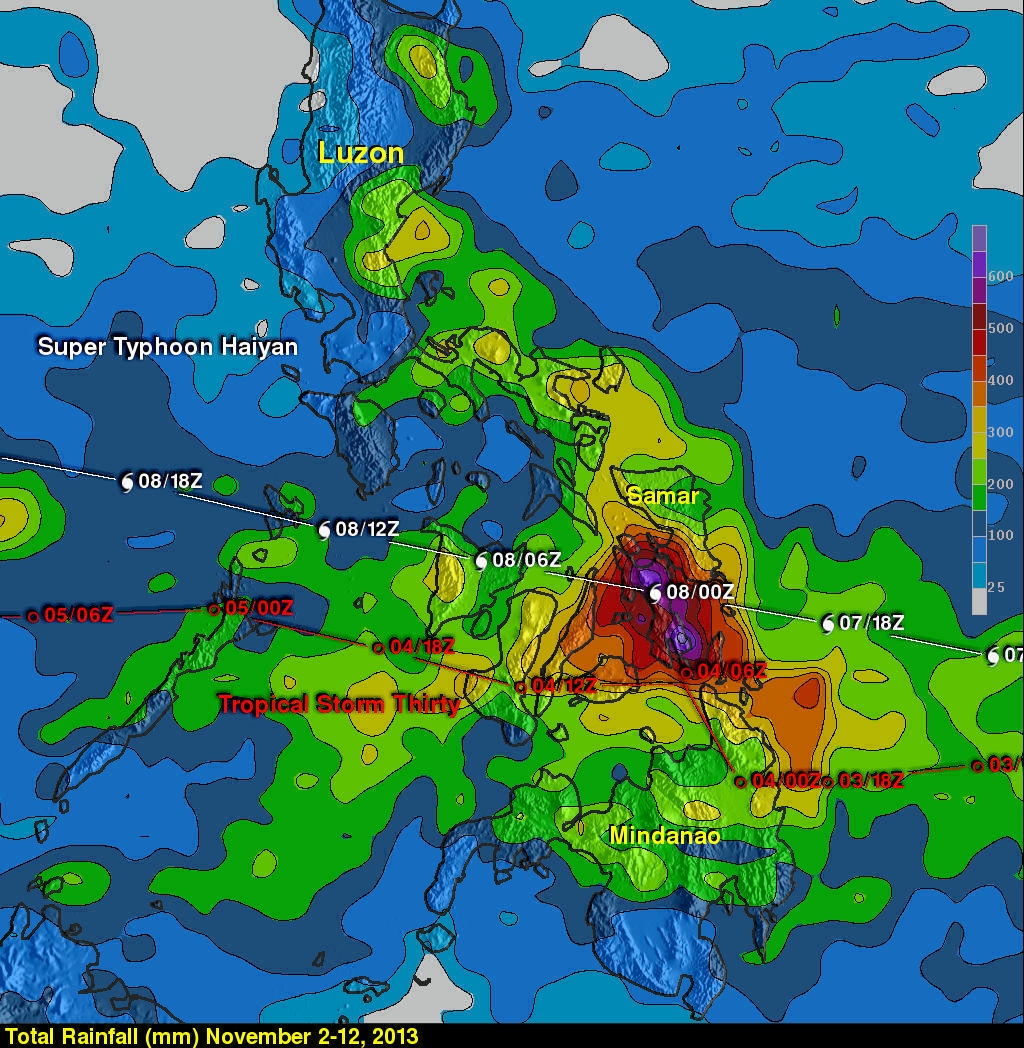
The most deadly flooding from Super Typhoon Haiyan was caused by the storm surge, which was reported to be up to 5.2 meters (~17 feet) in Tacloban, located on the northeast tip of Leyte, where the strong cyclonic winds from Haiyan funneled water into the northwest corner of Leyte Gulf between the islands of Leyte and Samar. In addition to the fierce winds and powerful surge, Haiyan brought copious amounts of rainfall to the central Philippines along with Tropical Storm Thirty and another tropical disturbance (90w), which all passed through the the central Philippines within in the past ten days. The combined rainfall from these tropical cyclones is shown in the TRMM-based, near-real time Multi-satellite Precipitation data (TMPA) analysis shown above during the period from November 2-12, 2013. It shows that most of the island of Leyte had rainfall totals greater than 500mm (~19.7 inches, dark red) with a peak amount of over 685 mm (~27 inches, lighter purple) located over the southeast corner of the island.
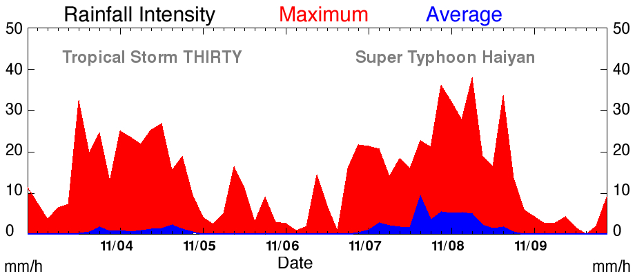
A graph of peak and average rainfall over the central Philippines shows that despite being far less intense, Tropical Storm Thirty, which preceded Super Typhoon Haiyan by about three days, produced similar peak rain intensities (shown in red) and over a similar duration, but less average rainfall (shown in blue) than Haiyan.
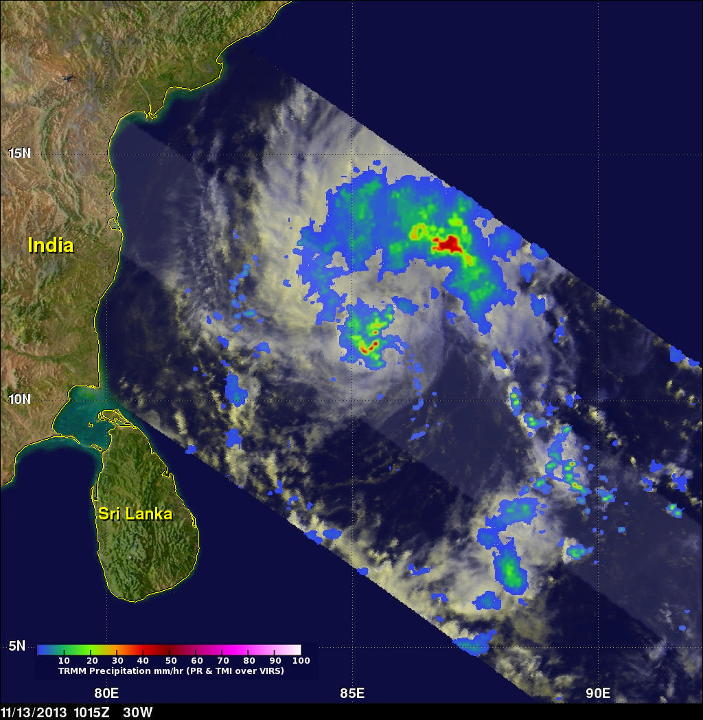
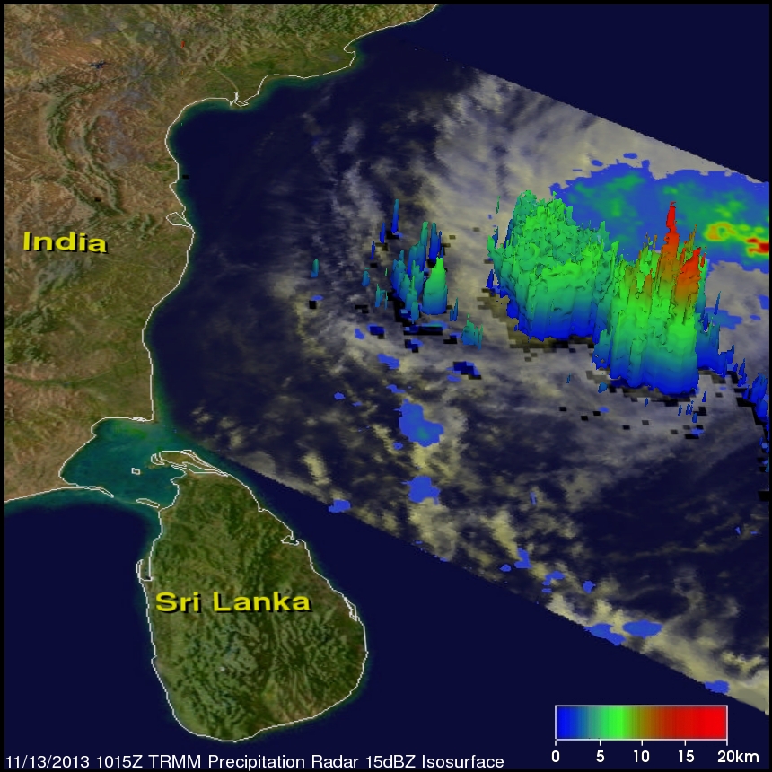
The remnants of what was once Tropical Storm Thirty (30W) over the Philippines have made there way into the Bay of Bengal after dropping heavy rainfall over Indochina. Tropical Depression 30W (Thirty) is now poised to bring rainfall to parts of India. The image above shows a TRMM satellite view of rainfall with the newly energized tropical disturbance in the Bay of Bengal on November 13, 2013 at 10:15 UTC. TRMM's Microwave Imager (TMI) and Precipitation Radar (PR) instruments found rain falling at a rate of over 81 mm/hr (~3.2 inches) in convective storms at 11.0N 85.2W near the center of the tropical disturbance. The image below shows a 3-D view of 30W using data from TRMM's Precipitation Radar (PR) instrument. TRMM's PR found that a few of the powerful convective storms near the center of the tropical depression were reaching heights of 15.5 km (~9.6 miles). .
Click here for earlier information on Super Typhoon Haiyan