
Data Sources
This page describes the various websites and tools for downloading, analyzing and visualizing GPM and TRMM data.
The NASA Goddard Earth Sciences (GES) Data and Information Services Center (DISC) is one of twelve NASA Science Mission Directorate (SMD) Data Centers that provide Earth science data, information, and services to research scientists, applications scientists, applications users, and students. The GES DISC is the home (archive) of NASA Precipitation and Hydrology, as well as Atmospheric Composition and Dynamics remote sensing data and information. The DISC also houses the Modern Era Retrospective-Analysis for Research and Applications (MERRA) data assimilation datasets (generated by GSFC’s Global Modeling and Assimilation Office), and the North American Land Data Assimilation System (NLDAS) and Global Land Data Assimilation System (GLDAS) data products (both generated by GSFC's Hydrological Sciences Branch).
Homepage:
Giovanni is a Web-based application developed by the Goddard Earth Sciences Data and Information Services Center (GES DISC) that provides a simple and intuitive way to visualize, analyze, and access vast amounts of Earth science remote sensing data without having to download the data (although data downloads are also supported). Giovanni is an acronym for the Geospatial Interactive Online Visualization ANd aNalysis Infrastructure.
Homepage:
The official website for NASA's Global Precipitation Measurement mission.
Homepage:
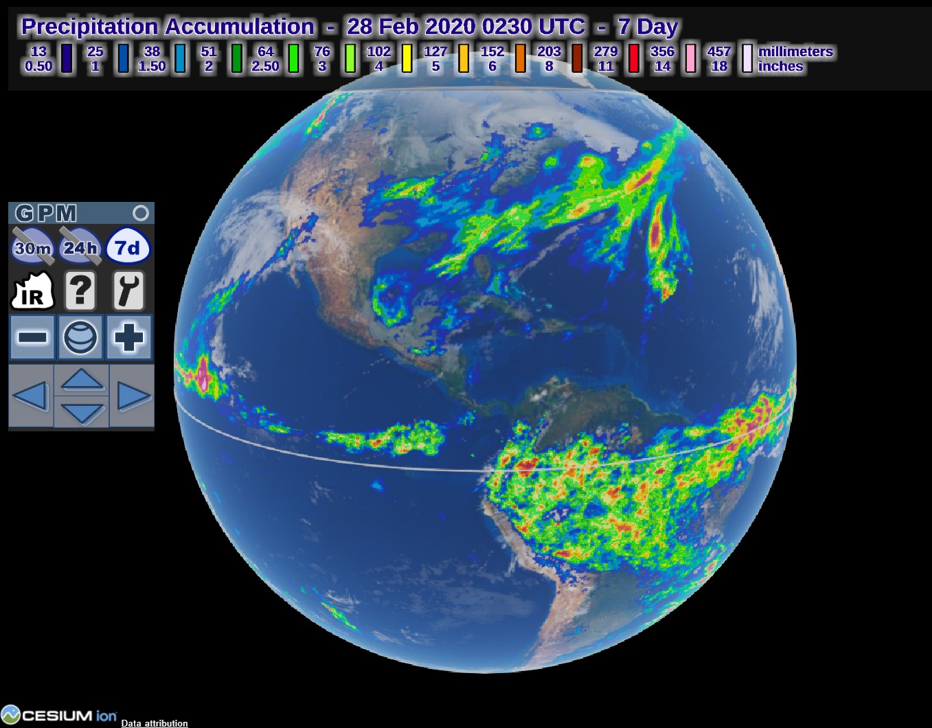
View the latest GPM IMERG data on a 3D globe in your web browser.
Image
Example of data displayed in the IMERG Global Viewer.
The NASA Disasters Mapping Portal, managed by the NASA Earth Applied Sciences Disasters Program, is a powerful ArcGIS-based online interface for viewing, analyzing and downloading the latest near-real-time products and disaster response datasets.
Homepage:
The mission of the Global Hydrometeorology Resource Center (GHRC) DAAC is to provide a comprehensive active archive of both data and knowledge augmentation services with a focus on hazardous weather, its governing dynamical and physical processes, and associated applications. Within this broad mandate, GHRC will focus on lightning, tropical cyclones and storm-induced hazards through integrated collections of satellite, airborne, and in-situ data sets.
Homepage:
View and download the latest near real-time GPM datasets for the past 60 days, in addition to landslide nowcast data.
Homepage:
The Near-Realtime PPS data server "Jsimpson" contains low latency products from the GPM and TRMM missions. Click here to learn about the difference between low latency / near real-time and research / production products.
The NASA Precipitation Processing System (PPS) evolved from the Tropical Rainfall Measuring Mission (TRMM) Science Data and Information System (TSDIS). The purpose of the PPS is to process, analyze and archive data from the Global Precipitation Measurement (GPM) mission, partner satellites and the TRMM mission. The PPS also supports GPM by providing validation products from GPM ground radar sites. All GPM, TRMM and Partner public data products are available to the science community and the general public from the GPM / TRMM Data Archive. Please note that you need to register to be able to access this data.
Homepage:
The Research PPS data server "Arthurhou" contains research-quality products from the GPM and TRMM missions. Click here to learn about the difference between low latency / near real-time and research / production products.
The NASA Precipitation Processing System (PPS) evolved from the Tropical Rainfall Measuring Mission (TRMM) Science Data and Information System (TSDIS). The purpose of the PPS is to process, analyze and archive data from the Global Precipitation Measurement (GPM) mission, partner satellites and the TRMM mission. The PPS also supports GPM by providing validation products from GPM ground radar sites. All GPM, TRMM and Partner public data products are available to the science community and the general public from the GPM / TRMM Data Archive. Please note that you need to register to be able to access this data.
Homepage:
Science Team On-Line Request Module (STORM) is a publicly available web-based data access interface for the Global Precipitation Measurement (GPM) Mission's Precipitation Processing System (PPS). PPS is one of the first measurement-based processing systems approved by NASA Headquarters; it employs a recognized scientific measurement and provides continuity between data from previous and future satellite missions. PPS generates precipitation data using radar and microwave measurements from the Precipitation Measurement Missions (PMM), including GPM and the Tropical Rainfall Measuring Mission (TRMM). The purpose of STORM is to provide the science community, students, and the public with an opportunity to learn about GPM data, search for data, order custom subsets, and subscribe to receive subset products produced in the future.
Homepage: