US East Coast

NASA Aids Response to Carolina Flooding
It was rain that wouldn't quit. A weather system fueled by warm moisture streaming in from the Atlantic Ocean on Oct. 3 and 4 relentlessly dumped between one and two feet of rain across most of South Carolina. The result was rivers topping their banks and dams bursting. Catastrophic flooding followed across most of the state, which has left residents in some areas without power or clean drinking water. Tracking and predicting the deluge, both as rain and then floodwater, are the first steps to help protect people in harm's way. State and federal emergency managers have been on the front lines...

IMERG Measures Historic Rainfall With A Nor'easter and Joaquin

NASA's Integrated Multi-satellitE Retrievals for GPM (IMERG) data were used to estimate the historic amount of rain that fell during the past week in the Carolinas. A "fire hose" of moisture has been pumped into the Carolinas from hurricane Joaquin resulting in wide spread flooding. Over two feet of rain have been reported in South Carolina. This analysis indicated that major hurricane Joaquin also dropped over 700 mm (27.5 inches) in the Bahamas. Hurricane Joaquin has weakened from a category four hurricane in the Bahamas to a category one hurricane affecting Bermuda. Click here to see a

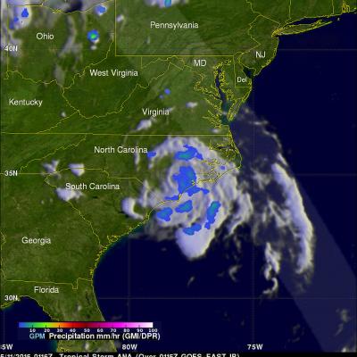
Joaquin Becomes a Hurricane, Could Impact the US East Coast

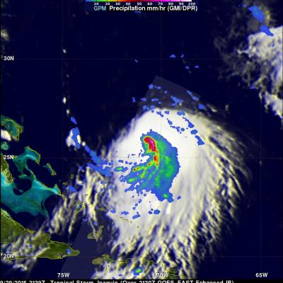
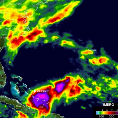
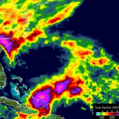
Joaquin, which became a tropical storm Monday evening (EDT) midway between the Bahamas and Bermuda, has now formed into a hurricane, the 3rd of the season--the difference is Joaqin could impact the US East Coast. GPM captured this image of Joaquin late yesterday afternoon at 21:39 UTC (5:39 pm EDT) on the 29th of September as Joaquin was moving very slowly towards the west-southwest about 400 miles east of the northwestern Bahamas. This first image shows rain rates derived from GPM's GMI microwave imager (outer swath) and DPR space-borne precipitation radar (inner swath) overlaid on IR data

Ana Becomes First 2015 Atlantic Tropical Storm & Weakens Ashore

On May 9, 2015 at 1626 UTC ( 12:26 PM EDT) the GPM satellite flew over when Ana was making the change from subtropical storm to tropical storm. Convective storms near the inner-core region were warming the center of the storm with heat generated by condensation. GPM's Microwave Imager (GMI) measured rain falling at at rate of over 58.7 (2.31 inches) per hour in these convective storms near ANA's center. The lighter swath to the west of Ana's center shows the area viewed by GPM's Ku/Ka-band Dual-frequency Precipitation Radar (DPR). On Sunday morning (May 10, 2015) Tropical storm ANA dropped

A GPM View of Tornado Spawning Thunderstorms

Twelve tornado sightings reported to NOAA yesterday were associated with severe thunderstorms extending from the Texas Gulf coast, through Oklahoma and Kansas. The GPM core observatory satellite had a good look at this area of severe weather on April 17, 2015 at 0003 UTC (April 16, 2015 at 7:03 PM CDT). A precipitation analysis using GPM's Microwave Imager (GMI) shows that some of these severe storms were dropping rain at a rate of over 86 mm (about 3.4 inches) per hour. Reflectivity data from the Ku band on GPM's dual frequency radar was used to construct this 3-D view of tornado spawning
GPM Data from a March 2014 Snostorm
Image Credit: NASA's Goddard Space Flight Center Download this video in HD formats from NASA Goddard's Scientific Visualization Studio The most accurate and comprehensive collection of rain, snowfall and other types of precipitation data ever assembled now is available to the public. This new resource for climate studies, weather forecasting, and other applications is based on observations by the Global Precipitation Measurement (GPM) Core Observatory, a joint mission of NASA and the Japan Aerospace Exploration Agency (JAXA), with contributions from a constellation of international partner...

A Week of Heavy Rainfall With Stormy Weather

During the past week many areas of the United States from Kansas to the Atlantic seaboard have been hit by heavy rainfall. Flash floods have created hazards in several areas from Texas to Washington, DC. Some parts of Texas got more rain in two days than received in the past year. Tornadoes were reported in some part of the United States every day of the past week except Tuesday from May 9-16, 2014. The TRMM Multi-Satellite Precipitation Analysis (TMPA), produced at Goddard Space Flight Center, combines the rainfall estimates generated by TRMM and other satellites (3B42). The analysis above