tropical cyclones

Tropical Cyclone Eliakim's Deadly Rainfall

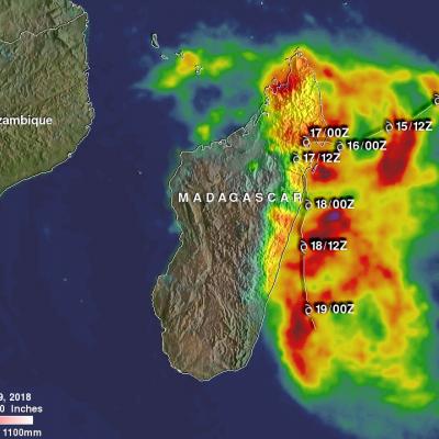
Tropical cyclone ELIAKIMS's heavy rainfall caused flooding and landslides over eastern Madagascar that resulted in at least seven deaths. ELIAKIM came less than two weeks after another tropical cyclone called Dumazile passed close to Madagascar. ELIAKIM maintained but didn't exceed tropical storm intensity as it battered Madagascar. ELIAKIM's slower movement as it passed over the island nation caused continuous heavy rainfall over northeastern Madagascar. Tropical cyclone ELIAKIM has now moved back into the Indian Ocean and is moving toward the southeast and away from Madagascar. This rainfall

GPM Sees Tropical Cyclone Eliakim Forming, Threatening Madagascar

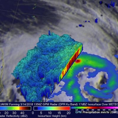
The Joint Typhoon Warning Center (JTWC) issued it's first warning for tropical cyclone ELIAKIM on March 15, 2018 at 0300 UTC as the tropical cyclone moved closer to the northeastern tip of Madagascar. It's maximum sustained wind speeds had increased to 50 kts (57.5 mph) by March 15, 1200 UTC. Forming tropical cyclone ELIAKIM was shown with improved organization when the GPM core observatory satellite flew above on March 14, 2018 at 1356 UTC. GPM's Dual Frequency Precipitation Radar (DPR) data revealed that intense convective storms were occurring in the northwest quadrant of the forming

Forming Tropical Cyclone Near Madagascar Inspected By GPM

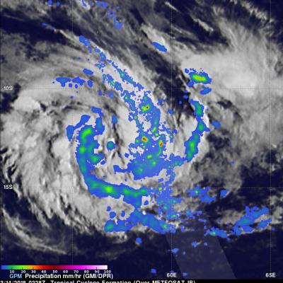
A new tropical cyclone may affect Madagascar in a few days. The Joint Typhoon Warning Center (JTWC) has been keeping an eye on an area of convection in the Indian Ocean northeast of Madagascar. A circulation center has already been observed. Environmental conditions are favorable for the birth of a tropical cyclone in that area with the presence of low vertical wind shear and warm sea surface temperatures. Tropical cyclone AVA caused many deaths in January when it's heavy rains caused extensive flooding in Madagascar. Tropical cyclone DUMAZILE also caused extensive flooding less than two weeks

GPM Satellite Scans Powerful Tropical Cyclone Hola

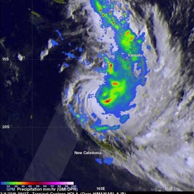
The GPM core observatory satellite had a fairly good look at powerful tropical cyclone HOLA on March 8, 2018 at 0812 UTC. HOLA was located northeast of New Caledonia with maximum sustained winds of about 95 kts (~ 105 mph). The rainfall in this image was derived from data received by GPM's Microwave Imager (GMI) and Dual Frequency Precipitation Radar (DPR) instruments. GPM's GMI provided the best coverage of the tropical cyclone. GMI data indicated that storms within HOLA were dropping rain at a rate of greater than 49 mm (1.9 inches) per hour in the southeast quadrant of the tropical cyclone

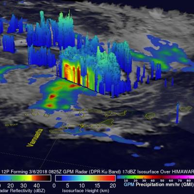
GPM Observes Tropical Cyclone 12P Forming

On March 6, 2018 at 0825 UTC the GPM core observatory satellite flew above a forming tropical cyclone in the southern Pacific Ocean just east of Vanuatu. GPM's Dual Frequency Precipitation Radar (DPR) scanned storms in the center of forming tropical cyclone 12P's circulation. This view by GPM's DPR revealed that convective storms were dropping extremely heavy rainfall on the eastern edge of the forming tropical cyclone's low level center. DPR indicated that rain was falling at a rate of over 241 mm (9.5 inches) per hour in this area. The use of GPM satellite's radar data enabled this 3-D view

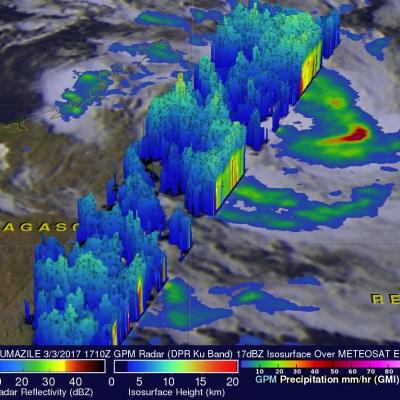
GPM Examines Tropical Cyclone Dumazile's Flooding Rainfall

Tropical cyclone DUMAZILE formed east of Madagascar on March 3, 2018. Since then the tropical cyclone has been causing flooding as the tropical cyclone moves parallel to Madagascar's eastern coast. The clockwise rotation of the tropical cyclone has been transporting bands of rain onto Madagascar. Over 210 mm (8.3 inches) of precipitation was reported along the northeastern coast of Madagascar. The GPM core observatory satellite passed over eastern Madagascar on March 3, 2018 at 1710Z. Tropical cyclone DUMAZILE was located in the Indian Ocean east of northeastern Madagascar. The tropical

GPM Sees Tropical Cyclone Kelvin Develop Cloudless Eye After Landfall in Australia

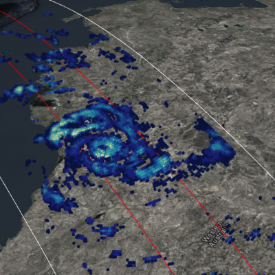
Tropical Cyclone Kelvin struck Northwestern Australia with winds reaching 54 knots as it crossed the Kimberley Coast. It brought flooding rains and damaging winds to the settlements and mining companies of the region. The storm intrigued meteorologists as it only developed a cloudless eye after making landfall, believed in part due to the heat flux generated by the warm desert the storm traveled over. View this visualization in full screen using STORM Event Viewer

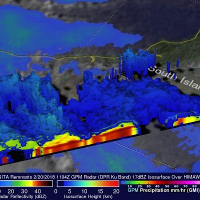
GPM Examines Tropical Cyclone Gita Remnants Over New Zealand

As predicted, the remnants of tropical cyclone GITA hit New Zealand on Tuesday (local time). GITA had transitioned to an extra-tropical low and was much weaker than when it hit Tonga last week. It still contained strong tropical strong force winds with occasionally heavy rainfall. New Zealand's South Island was the hardest hit. The northern end of of the South Island was in the right front quadrant of the tropical cyclone where the wind speeds around the center of circulation were increased by the low's speed of movement. Torrential rainfall led to flooding and landslides on the South Island

Cyclones Gita's Rainfall Measured With GPM's Microwave Imager (GMI)

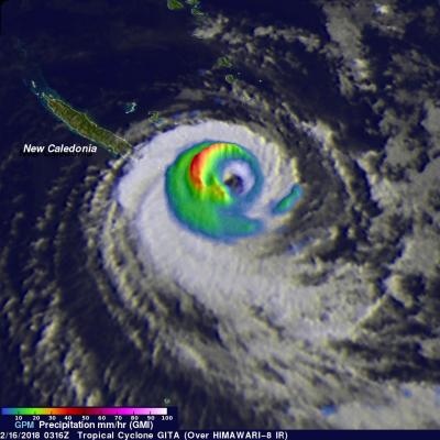
The GPM core observatory satellite's Microwave Imager (GMI) instrument had a fairly good view of tropical cyclone GITA on February 2018 at 0316 UTC. GPM's Dual Frequency Precipitation Radar (DPR) swath only scanned the area west of GITA's main area of precipitation. The weakening tropical cyclone was passing the southeastern tip of New Caledonia. Although weakening, GITA still had winds estimated at over 90 kts (104 mph). Rainfall derived from GMI data showed that the heaviest precipitation, falling at rate of about 51 mm (2 inches) per hour, was shown west of GITA's low level circulation

Destructive Tropical Cyclone Gita's Rainfall Measured With IMERG

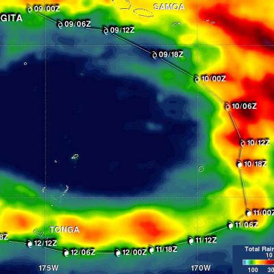
Tropical cyclone GITA recently battered and drenched first Samoa and then Tonga as it passed close to both island groups. GITA was a tropical storm with winds of about 40 kts (46 mph) when it passed to the south of Samoa but still caused widespread destruction and flooding. The president of the United States approved a disaster declaration for Samoa. The tropical cyclone's winds had increased to about 125 kts (144 mph) when it battered Tonga as the equivalent of a category four hurricane on the Saffir-Simpson hurricane wind scale. Destructive winds were the main cause of destruction but heavy