Talim

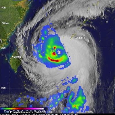
GPM Examines Typhoon Talim's Large Eye

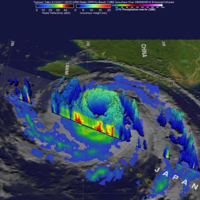
The GPM cored observatory had another outstanding view of typhoon Talim in the western Pacific Ocean on September 13, 2017 at 1537 utc. A large eye was Talim's most distinctive feature. GPM's Microwave Imager (GMI) and Dual-Frequency Precipitation Radar (DPR) showed the location of intense rainfall within Talim's distinct eye wall. DPR revealed that rain was falling at a rate of over 232 mm (9.13 inches) per hour in convective storms in the western side of the typhoon's eye wall. GPM also showed that rainfall was far weaker to the the east of Talim's center. This dramatic 3-D view of Talim's

GPM Sees Typhoon Talim Threatening Islands Of Japan

The Joint Typhoon Warning Center (JTWC) predicts that typhoon Kalim in the western Pacific Ocean will intensify and threaten the islands of southern Japan in the the new three days. Environmental conditions such as low vertical wind shear and warm sea surface temperatures are favorable for Talim's intensification. Talim's winds are expected to increase to a peak of 115 kts as it re-curves toward the the Japanese island of Kyushu. The GPM core observatory satellite scanned the western side of typhoon Talim on September 13, 2017 at 0216 UTC. GPM's Microwave Imager (GMI) instrument collected data

Tropical Storm Talim Weakens, Moves Over Japan

Both Taiwan and Southern Japan have had extreme amounts of rainfall contributed by tropical cyclones during the past week. Tropical storm Talim weakened to a tropical depression on June 18, 2012 after passing over the northern tip of Taiwan. Flooding, landslides and at least one death in Taiwan were reportedly caused by Talim. The weakening tropical depression is now affecting Japan in areas that were just drenched by Typhoon Guchol's passage. This image shows rainfall from data collected with two TRMM satellite orbits as it passed over that area. TRMM passed over on June 20, 2012 at 2308 UTC

Tropical Storm Talim's Heavy Rainfall Over Taiwan

Tropical storm Talim has produced torrential rainfall over southern Taiwan as it pumped warm moist air from the South China Sea over mountainous terrain. The TRMM satellite flew over tropical storm Talim in the Taiwan Strait on 20 June 2012 at 0140 UTC. TRMM Precipitation Radar (PR) data from this orbit shows that tropical storm Talim was dropping rainfall at a rate of almost 50mm/hr over Taiwan. TRMM data captured with that orbit shows that the most intense rainfall of over 50mm/hr (~2 inches) was located over the Strait Of Taiwan. Flash flooding and landslides are probable in southern Taiwan