Hal Pierce

Tropical Cyclone Ita Drenches Australia

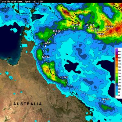
After coming ashore this past Friday tropical cyclone ITA dropped heavy rainfall over the weekend that caused flooding in many areas of northeastern Australia's state of Queensland. IDA has now moved back into the Coral Sea. The analysis above shows a TRMM-based near-real time Multi-satellite Precipitation Analysis (TMPA) made at the NASA Goddard Space Flight Center. This analysis used TMPA precipitation data from April 1-14, 2014 during the period when ITA formed in the Coral Sea and moved along northeastern Australia's coast. IDA's locations at 0600 UTC are shown overlaid in white. The

Powerful Tropical Cyclone Ita Hits Australia

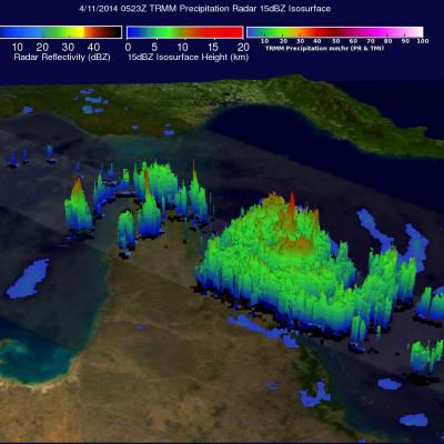
As predicted, powerful tropical cyclone ITA hit the Queensland coast of northeastern Australia late Friday (local time). At that point ITA was a category four on the Saffir-Simpson hurricane intensity scale with winds estimated at over 120 kts (about 138 mph) . This intensity was down slightly from ITA's estimated peak sustained wind speed of 135kts (about 155 mph) when the dangerous tropical cyclone was approaching Australia. The TRMM satellite passed almost directly above as tropical cyclone ITA was approaching the Queensland coast on April 11, 2014 at 0523 UTC. At the time of this TRMM view

Tropical Cyclone Ita Intensifies

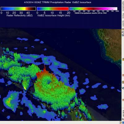
The TRMM satellite flew above intensifying tropical cyclone ITA in the Coral Sea near the southeastern tip of Papua New Guinea on April 9, 2014 at 0536 UTC. The tropical cyclone had developed a large but well defined eye and had sustained winds estimated at 65kts (about 75mph). Rainfall derived from TRMM's Microwave Imager (TMI) and Precipitation Radar (PR) data was used in the analysis shown here. TRMM PR data unveiled rain falling at a rate of over 99mm/hr (about 3.9 inches) within ITA's feeder bands over the coast of southeastern Papua New Guinea. TRMM PR found that tall thunderstorms in

TRMM Sees Severe Weather

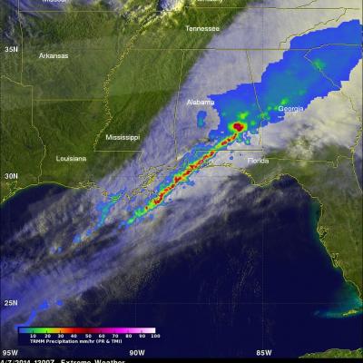
The TRMM satellite flew over the southeastern United States on April 7, 2014 at 1300 UTC (9:00 AM EDT) when a line of intense thunderstorms was moving through the area. Tornado watches were in effect over much of the area. A possible tornado, associated with the same weather system, caused destruction and injuries when it moved through southern Mississippi earlier at about 2 AM EDT. TRMM's Precipitation Radar (PR) data revealed that rain was falling at a rate of over 130mm/hr (about 5.1 inches) in one severe thunderstorm near the Alabama and Florida panhandle border. A radar reflectivity value

Tropical Cyclone Hellen's Lively Remnants

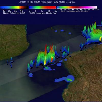
Powerful tropical cyclone Hellen rapidly weakened after hitting northwestern Madagascar but Hellen's remnants have recently started to show signs of life. The TRMM satellite flew over these remnants in the Mozambique channel on April 2, 2014 at 0143 UTC. A rainfall analysis using TRMM's Microwave Imager (TMI) and Precipitation Radar (PR) instruments found that some strong convective thunderstorms had developed in the area. It was revealed by TRMM PR data that rain was falling at a rate of over 75 mm/hr (almost 3 inches) in a few locations.

Gillian Has Second Life

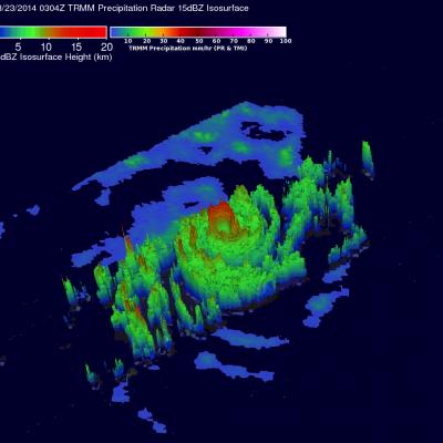
Tropical cyclone Gillian re-generated in the South Indian Ocean south of Indonesia on March 21, 2014. Gillian had peak wind speeds of about 140 kts (about 173 mph) on March 23, 2014 making it a Category 5 hurricane on the Saffir-Simpson Scale. The TRMM satellite flew above GILLIAN when the tropical cyclone was intensifying on March 23, 2014 at 0304 UTC. Data from TRMM's Microwave Imager (TMI) and Precipitation Radar (PR) instruments were used in the rainfall analysis on the above left. TRMM PR revealed that Gillian had very intense storms in a well defined eye wall producing rain at a rate of

Gillian's Persistent Remnants

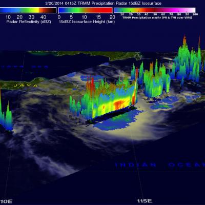
The persistent remnants of tropical cyclone GILLIAN have moved westward over 2700km (about 1674 miles) since forming in the Gulf Of Carpentaria on March 8, 2014. GILLIAN's coherent remnants were located just to the southeast of the Indonesian island of Java when the TRMM satellite flew over on March 20, 2014 at 0415 UTC. TRMM's Precipitation Radar (PR) instrument revealed that intense convective storms in this area were still dropping rain at a rate of over 97 mm/hr (about 3.8 inches) and returning radar reflectivity values of over 51dBZ. TRMM PR data were used in the simulated 3-D view on the

Tropical Cyclone Gillian's Remnants

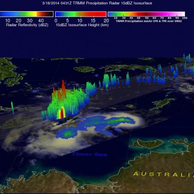
Over the past few days former tropical cyclone GILLIAN's remnants moved from the Gulf Of Carpentaria into the Timor sea . The TRMM satellite found a few strong convective thunderstorms when it passed above these remnants on March 18, 2014 at 0431 UTC. TRMM's Precipitation Radar (PR) instrument measured rain falling at a rate of over 86 mm/hr (~3.4 inches) in some intense storms. The simulated 3-D image above was made using TRMM PR data and shows that several of the tallest thunderstorms in GILLIAN's remnants were reaching heights of over 15.75 km (~9.8 miles). Radar reflectivity values of over

Tropical Cyclone Formation

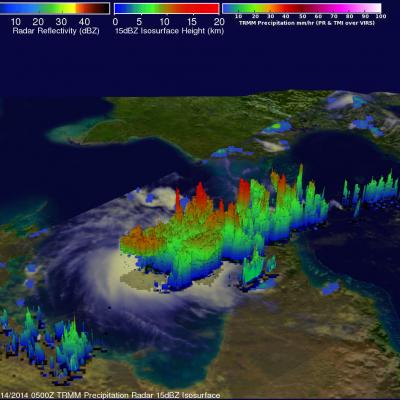
The TRMM satellite flew above northern Australia on March 14, 2014 at 0500 UTC capturing data used in the image on the right. Very strong convective storms in this area are the remnants of tropical cyclone GILLIAN and may signal a rebirth. TRMM's Precipitation Radar (PR) instrument found rain falling at the rate of over 116 mm/hr (~4.5 inches) in these powerful storms in the northeastern Gulf Of Carpentaria. TRMM PR data were also used in this 3-D view of the strong convective storms in the northern Gulf Of Carpentaria. Some towering convective storms were found to be very energetic. Several

Deadly Tropical Cyclone Lusi

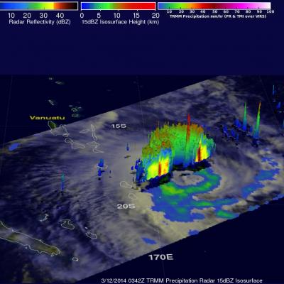
Tropical cyclone LUSI recently caused the deaths of at least three people as it moved through the island nation of Vanuatu in the South Pacific Ocean. The TRMM satellite flew above tropical cyclone LUSI on March 12, 2014 at 0342 UTC. A rainfall analysis made from TRMM's Microwave Imager (TMI) and Precipitation Radar (PR) data is shown overlaid on an enhanced visible/infrared image from TRMM's Visible and InfraRed Scanner (VIRS). TRMM PR data revealed with this analysis that rain was falling at a rate of over 97 mm/hr (~3.8 inches) in rain bands rotating around LUSI's center. TRMM's