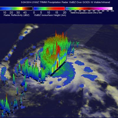
The first hurricane of the eastern Pacific hurricane 2014 season, called Amanda, reached wind speeds estimated at 135 kts (about 190 mph) on May 25, 2014. This made it a category four on the Saffir-Simpson hurricane wind scale. Fortunately the powerful hurricane was over open waters well to the southwest of Mexico's coast when the maximum intensity was reached. The images above show data collected when the TRMM satellite passed overhead on Saturday May 24, 2014 at 2150 UTC. Rainfall data from TRMM's Microwave Imager (TMI) and Precipitation Radar (PR) instruments are shown overlaid on a GOES-15
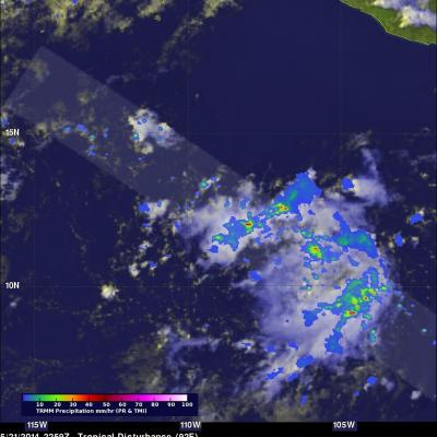
The Eastern Pacific hurricane season began on May 15, 2014 and today a potential tropical cyclone is forming south-southwest of Manzanillo, Mexico. The TRMM satellite collected data as it flew above this area on May 21, 2014 at 2259 UTC. TRMM's Precipitation Radar (PR) found rain falling at over 102.5 mm/hr (about 4 inches) in some convective showers and thunderstorms in this area. A GOES-WEST image was overlaid with a rainfall analysis from TRMM PR and TMI. TRMM's Precipitation Radar (PR) data were used to show a 3-D view of the rainfall structure in this disturbed weather. A few strong
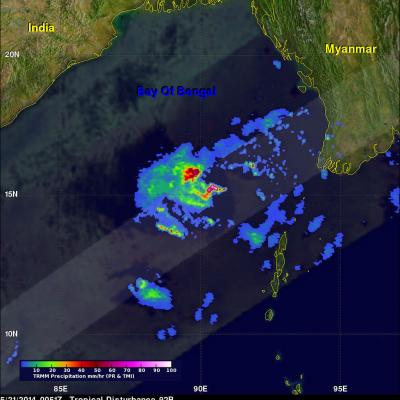
The tropical disturbance (92B) in the Bay Of Bengal was raining heavily when the TRMM satellite flew almost directly above on May 21, 2014 at 0051 UTC. TRMM's Precipitation Radar (PR) revealed that rain was falling at the extreme rate of over 191 mm/hr (about 7.5 inches) in powerful convective storms in the center of the Bay Of Bengal well to the east of India. TRMM's Precipitation Radar data were also used to construct this simulated 3-D view, looking toward the east from India, of 92B's rainfall structure. TRMM PR pulled away a veil of clouds and revealed that some powerful convective storm
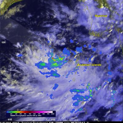
On May 19, 2014 at 1056 UTC TRMM flew over a tropical low (92B) in the Bay Of Bengal east of India. TRMM's Precipitation Radar (PR) instrument found that rain was falling at a rate of over 138 mm/hr (about 5.4 inches) in some strong convective storms. A rainfall analysis from TRMM's Microwave Imager (TMI) and Precipitation Radar (PR) data is shown overlaid on a METEOSAT-7 visible/infrared image captured at 1100 UTC . TRMM PR data were also used in this 3-D image that shows a simulated view of the tropical disturbance's rainfall structure. Tall storms were shown reaching heights of over 14km
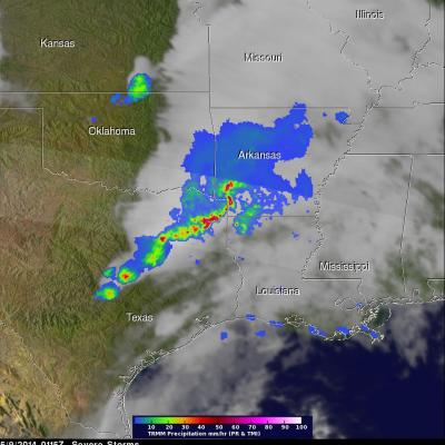
Severe weather was extending from Minnesota to southern Texas on Thursday afternoon and Friday morning. During that time there were three tornadoes reported in Minnesota, two in Colorado and two in Missouri. The TRMM satellite flew above tornado spawning thunderstorms in the southern United States on May 9, 2014 at 0115 UTC (May 8, 2014 at 8:15 PM CTD). A rainfall analysis from TRMM's Precipitation Radar (PR) and Microwave Imager (TMI) is shown overlaid on a GOES-EAST infrared image received at the same time. TRMM's PR instrument found rain falling at a rate of over almost 163 mm/hr (about 6.4
A tropical low was affecting southern India and Sri Lanka on May 6, 2014 at 0809 UTC when the TRMM satellite flew above. The TRMM satellite was launched by NASA and JAXA in 1997 with the first earth orbiting active/passive instrument package to study the intensity and structure of tropical rainfall. The GPM satellite that was launched on February 27, 2014 will continue TRMM's highly successful mission of monitoring precipitation from space. TRMM' Precipitation Radar (PR) data were used in this 3-D view (from the west) of rainfall structure within this area of disturbed tropical weather. TRMM
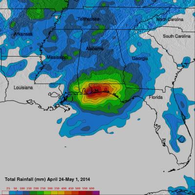
The TRMM satellite had a good view of recent extreme rainfall over the Florida panhandle that caused extensive flooding. TRMM Multi-satellite Precipitation Analysis (TMPA) data were used at NASA Goddard Space Flight Center to estimate total precipitation (mm) for the week from April 24 to May 1,2014. Rainfall totals of up to 620 mm (about 25 inches) were analyzed in the Pensacola, Florida area. The continuous "training" of heavy rainfall into the area was viewed several times by the TRMM satellite. The TRMM satellite flew above the area on April 30, 2014 at 0128 UTC (9:28 PM EDT April 29, 2014
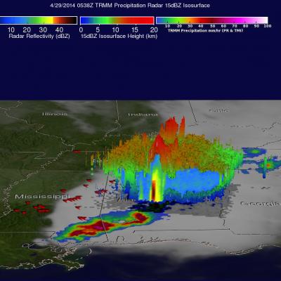
For the second day in a row deadly tornadoes hit the the southern United States. Mississippi was the hardest hit with nine people killed by tornadoes that hit Tupelo. The TRMM satellite had two good views as extreme weather continued moving through the area on Monday April 28, 2014 at 11:00 PM CDT (April 29, 2014 at 0400 UTC) and early Tuesday April 29, 2014 at 00:38 AM CDT (0538 UTC). Rainfall derived from TRMM's Microwave Imager (TMI) and Precipitation Radar (PR) data is shown overlaid on GOES-EAST infrared satellite images captured on April 29, 2014 at 0402 UTC and 0532 UTC. Red symbols
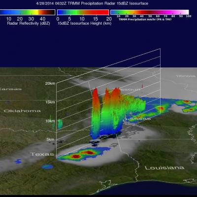
The TRMM satellite flew over the southern United States on April 28, 2014 at 0454 UTC (April 27, at 11:54 CDT) and April 28, 2014 at 0632 UTC (1:32 AM CDT). At both times severe weather pushing through the central and southern United States was observed by the satellite. Tornadoes associated with these areas of powerful thunderstorms killed at least 16 people with 14 deaths reported in Arkansas. Rainfall from TRMM's Microwave Imager (TMI) and Precipitation Radar (PR) instruments is shown above overlaid on GOES-EAST infrared satellite images received at close to the same time. The locations of
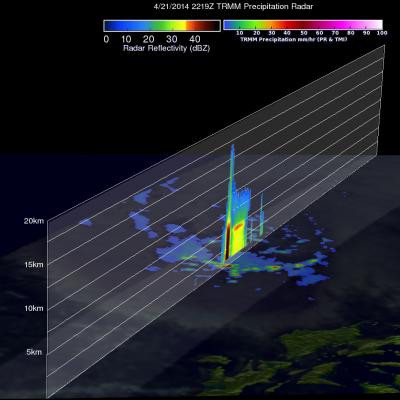
On April 21, 2014 at 2219 UTC the TRMM flew over stormy weather within a tropical disturbance near the Philippines. Precipitation from this tropical low adds to above normal rainfall for the Philippines during the past 30 days. Heavy rainfall with the slow moving remnants of tropical depression Peipah caused flooding in the Philippines earlier this month. TRMM's Precipitation Radar data were used to make a 3-D vertical slice through the tallest thunderstorm towers in this area of stormy weather. This slice shows that some storms were returning radar reflectivity values of greater than 52dBZ