super typhoons

Super Typhoon Trami's Rainfall Examined By GPM

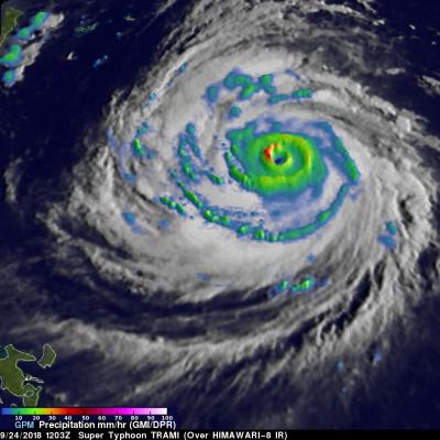
The GPM core observatory satellite probed super typhoon TRAMI when it traveled above the northwestern Pacific Ocean on September 24, 2018 at 1203 UTC. At that time TRAMI had maximum sustained winds estimated at 130 kts (150 mph). This image shows rainfall measurements that were made using data collected by GPM's Microwave Imager (GMI) and Dual-Frequency Precipitation Radar (DPR) instruments. GPM's GMI showed the locations of extremely heavy rainfall in the super typhoon's well defined circular eye. GPM's radar (DPR Ku Band) coverage was limited because it's swath only included storms on the

GPM Views Super Typhoon Mangkhut Moving Towards the Coast of China

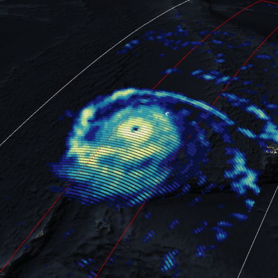
View Fullscreen in STORM Event Viewer A day after rolling through the southern Mariana Islands, causing wind and water damage to Guam and other nearby islands, Mangkhut has intensified into a Category 4 Super Typhoon with winds of 135 knots. With favorable conditions and the warm waters of the Philippine Sea, it is expected to maintain much of this intensity as it continues to track west-northwestward. Currently models anticipate Mangkhut to pass between the Phillipines and Taiwan, weakening slightly due to interaction with the two islands, before continuing toward the Southeastern Chinese

GPM Views Super Typhoon Maria Near Guam

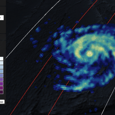
View full screen in STORM Event Viewer. Rapidly intensifying after its genesis near Guam, Super Typhoon Maria featured winds near 130 knots as it spiraled through the waters of the Western Pacific Ocean. The DPR scan indicates deep convection in several parts of the outer bands, with the most intense precipitation rates from GMI concentrated in the eyewall. Maria is expected to continue intensifying over the next three days, then weaken slightly as it crosses through the Ryukyu Islands, possible near Okinawa. The long range forecast has it making landfall in Northern China, possibly still as a

GPM Sees Super Typhoon Melor Hitting The Philippines

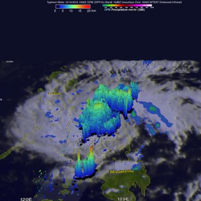
Super typhoon Melor (known in the Philippines as Nona) formed east of the Philippines on December 12, 2015. Melor became more powerful and became a typhoon the next day while heading toward the Philippines. The Joint Typhoon Warning Center (JTWC) indicated that Melor was a super typhoon with winds of 115 kts 115 kts (133 mph) just before hitting the Philippines .The GPM core observatory satellite passed above as super typhoon Melor was impacting the Philippines on December 14, 2015 at 1006 UTC. At that time Melor still had maximum sustained winds of about 115 kts (133 mph). Rainfall derived

Typhoon Soudelor Threatens Taiwan And China

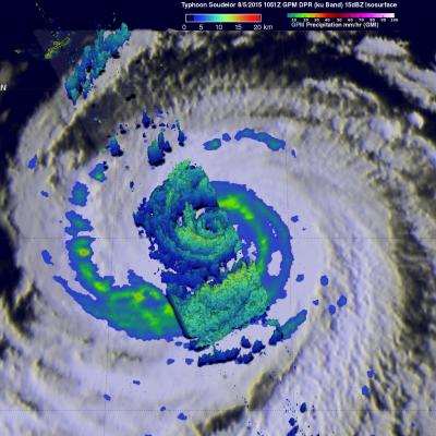
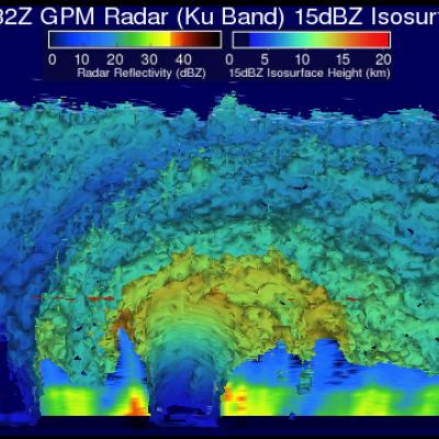
Typhoon Soudelor's sustained winds were about 105 kts ( about 121 mph) when the GPM core observatory satellite flew above on August 5, 2015 at 1051 UTC. A rainfall analysis was made from data collected from GPM's Microwave Imager (GMI) and Dual-Frequency Precipitation Radar (DPR) instruments. This analysis showed that Soudelor was very large and had a well defined eye. Intense feeder bands are shown spiraling into the center. Three dimensional radar reflectivity data GPM's DPR (ku Band) were used to construct a simulated cross section through typhoon Soudelor's center. This view from the south

TRMM Satellite Makes Direct Pass over Super Typhoon Maysak

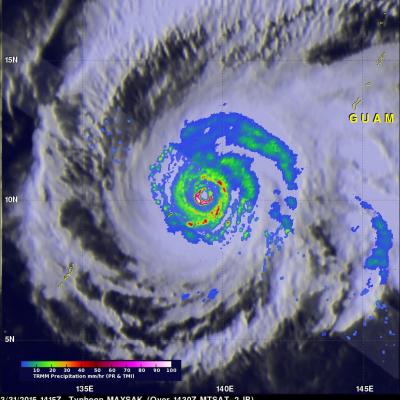
The Tropical Rainfall Measuring Mission satellite delivered a remarkable image of Super Typhoon Maysak on March 31. TRMM obtained an image straight over the top of a super typhoon with a double eye-wall, Super Typhoon Maysak, as it roared through the warm waters of the West Pacific south of Guam. This image with the TRMM Precipitation Radar or PR was taken at 14:15 UTC (10:15 a.m. EDT) on March 31, 2015 and shows the rain intensities within the very heart of Super Typhoon Maysak as it undergoes an eye wall replacement cycle. Mature, intense tropical cyclones can and often do undergo what is

Deadly Super Typhoon Hagupit Moved Slowly

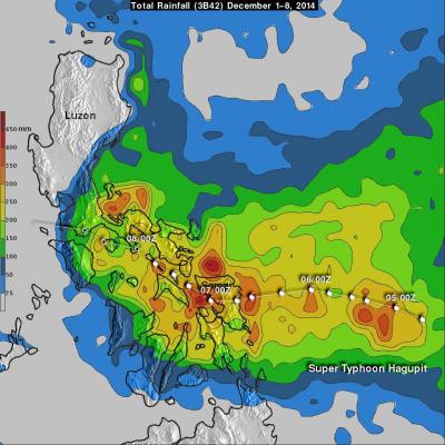
As of Today, super typhoon Hagupit has been deadly with up to 27 deaths reported but the Philippines has been spared the widespread destruction caused by Super typhoon Haiyan in 2013. Hagupit's (called Ruby in the Philippines) forward motion slowed on December 4, 2014 before reaching the Philippines. After hitting Samar in the eastern Philippines Hagupit's continued slow movement resulted in high rainfall amounts along the typhoon's track. These high rainfall totals meant that flooding occurred frequently along the typhoon's track. When the TRMM satellite flew over on December 8, 2014 at 0132

GPM Core Observatory Sees Hagupit's Eye

The GPM satellite flew almost directly above dangerous typhoon Hagupit on December 5, 2014 at 1032 UTC as the typhoon was approaching the Philippines. The GPM Microwave Imager (GMI) instrument measured rain falling at a rate of over 76 mm (almost 3 inches) per hour in the typhoon's eye wall. This 3-D view of Hagupit's precipitation structure was made using data from the Ku band on GPM's dual frequency radar instrument (DPR). DPR showed that some tall thunderstorm in Hagiput's eye wall were reaching heights of almost 15 km (about 9.3 miles). Click here to see a Low Resolution 640x360 simulated

Super Typhoon Hagupit Threatens Philippines

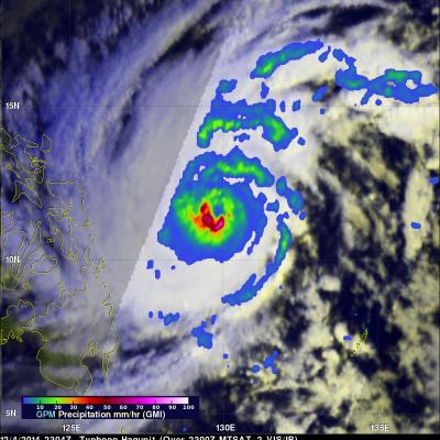
Super Typhoon Hagupit is threatening the Philippines a little over a year after deadly Super Typhoon Haiyan devastated the island nation in November 2013. Hagupit was weakening slightly from peak wind speeds of 155 kts (178 mph) when the GPM core observatory satellite passed over on December 4, 2014 at 2304 UTC in the image shown above. Hagupit had winds of about 125 kts (144 mph) when viewed by the TRMM satellite on December 5, 2014 at 0308 UTC in the image shown below. Rainfall data from these satellites are shown overlaid on daylight views from the MTSAT-2 satellite captured at close to the

Super Typhoon Haiyan Moving Toward The Philippines

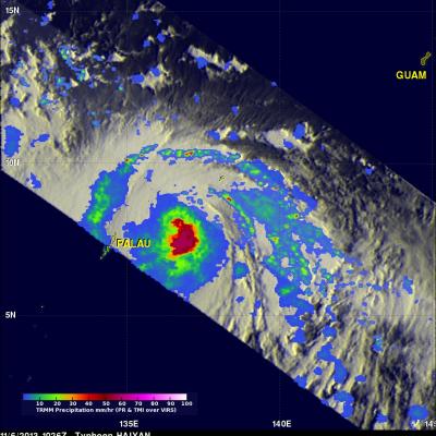
As predicted by the Joint Typhoon Warning Center (JTWC) typhoon Haiyan became a powerful category five typhoon with sustained winds estimated to be over 135kts (~155 mph). Super typhoon Haiyan is predicted to strike the central Philippines in a few days. Super typhoon Haiyan was located just northeast of Palau when the TRMM satellite flew above on November 6, 2013 at 1026 UTC. A rainfall analysis from TRMM's Microwave Imager (TMI) and Precipitation Radar (PR) instruments is shown overlaid on an enhanced infrared image from TRMM's Visible and InfraRed Scanner (VIRS). Data from TRMM's TMI and PR