

GPM Science Objectives
GPM is designed to advance scientific understanding of the Earth's water and energy cycle but also provides near real-time data for a wide array of societal applications. As a science mission with integrated application goals, the GPM mission has five scientific objectives:
Advancing Precipitation Measurement from Space
GPM advances precipitation measurement capability from space using a combination of active and passive remote-sensing techniques. These measurements are used to calibrate, unify and improve global precipitation measurements by a constellation of research and operational microwave sensors. In particular, GPM:
- Provides measurements of microphysical properties and vertical structure information using active remote-sensing techniques over a broad spectral range
- Measures snow and lighter rain rates through the use of high-frequency passive microwave radiometry
- Improves passive microwave retrieval (PWR) algorithms over land
- Improves precipitation measurements in mid- and high-latitudes during cold seasons
Improving knowledge of precipitation systems, water-cycle variability and freshwater availability
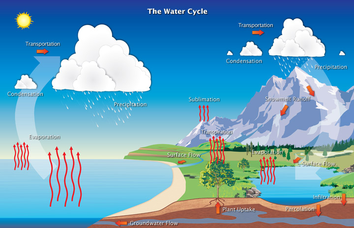
GPM provides 4-dimensional (4-D) measurements of space-time variability of global precipitation to help to quantify regional and global water cycle processes, serving to provide a better understanding of storm structures, water/energy budget, freshwater resources, and interactions between precipitation and other climate parameters. GPM:
- Quantifies the variability of regional and global water cycle processes directly or closely related to precipitation, on diurnal through decadal time scales, based on past, present and future global precipitation datasets
- Diagnoses the rate of water transfer within Earth's atmosphere and surface while reconciling individual terms in water budget equations, as well as detect accelerations and decelerations in the global water cycle and how such accelerations respond to and influence the global climate system
Improving climate modeling and prediction
GPM improves climate prediction through better understanding of surface water fluxes, soil moisture storage, cloud/precipitation microphysics and latent heat release in the atmosphere to improve Earth system modeling and analysis. GPM:
- Understands the role of cloud-scale precipitation processes in climate sensitivity and feedback
- Studies climate system variability and climate diagnostics
- Performs climate model simulations and reanalysis
- Elucidates the distribution and variance of latent heat release and bulk precipitation microphysics
- Can better understand the 4-D precipitation distribution and variability from diurnal to inter-annual time scales
- Improves datasets for climate analysis through assimilation of satellite-based precipitation information into global data assimilation systems
Improving weather forecasting and 4-D climate reanalysis
GPM advances numerical weather prediction (NWP) skills through more accurate and frequent measurements of precipitation-affected microwave radiances and instantaneous precipitation rates together with better quantitative error characterizations and improved weather forecasting and data assimilation systems. GPM:
- Improves NWP skills through assimilation of satellite-based precipitation information into numerical weather prediction systems
- Estimates and corrects systematic errors in moist processes parameterizations contained in numerical prediction models through effective use of satellite precipitation observations
- Employs advanced assimilation methods to extract maximum information from precipitation data in the presence of forecast model errors
- Improves the understanding and modeling of precipitation error properties
- Monitors extreme precipitation events and freshwater availability
- Improves position fixes for typhoon/hurricane predictions
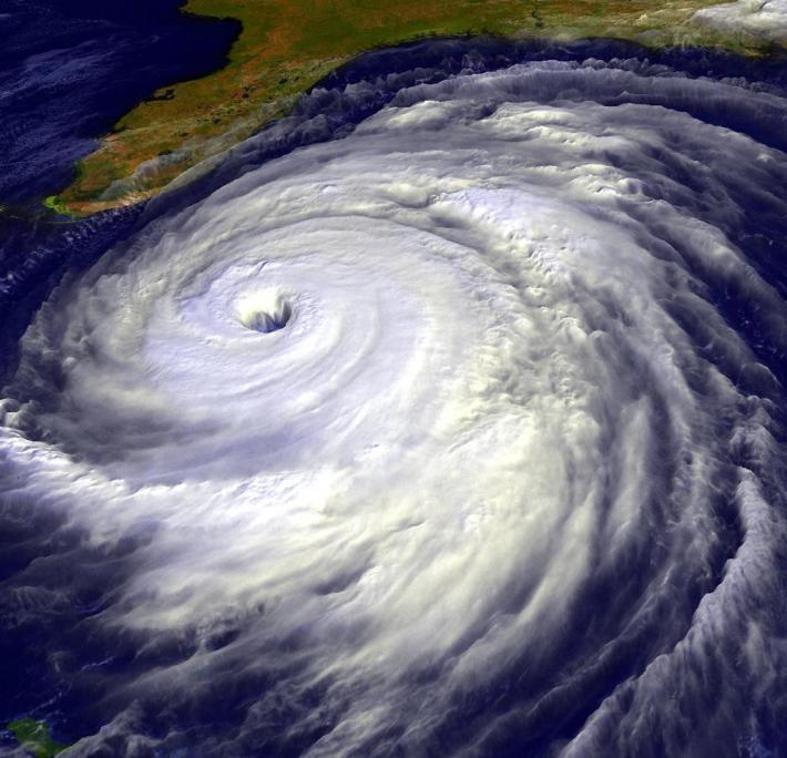
Visualization of Hurricane Floyd, created from NOAA GOES data.
Improving hydrological modeling and prediction
GPM is advancing predictions of high-impact natural hazard events such as floods, droughts, landslides and hurricanes by providing high-resolution precipitation data through downscaling and innovative hydrological modeling. GPM is:
- Developing hydrometeorological testbeds for evaluating the quality of satellite products in hydrological applications
- Improving techniques for global precipitation products based on combined satellite and ground measurements
- Quantifying anticipated improvements in surface runoff, infiltration, storage, surface moisture flux transfer and other hydrological processes commonly represented in hydrometeorological models
- Helping us understand the quantitative nature and physical causes of differences in surface fluxes simulated by hydrometeorological models operating in different modes
- Improving land surface data assimilation schemes for use in high resolution, nonhydrostatic, regional models, suited to availability of 3-hourly, high spatial resolution, globally available precipitation products
Please follow the links below to learn more about Precipitation Measurement Mission science, including:
- Storm Structure and Mesoscale Dynamics
- Precipitation Microphysics
- The Global Water Cycle
- Climate Change
- Precipitation Algorithms
- Ground Validation
Please follow the links below to learn more about TRMM and GPM societal applications, including: