Browse K - 5 Resources
Browse K - 5 Resources

Primary Topic:
Subtopics:
Type:
Summary:
A collection of resources exploring how NASA satellites like GPM can help monitor and predict Earth's climate.
Primary Topic:
Subtopics:
Type:
Summary:
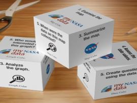
Using the My NASA Data Literacy Cubes will enhance students exploration of graphs, maps, and datasets to enrich their observations and inferences. The cubes offer an interactive and engaging way for participants to explore graphs, maps, and datasets.
Primary Topic:
Subtopics:
Type:
Keywords:
Summary:
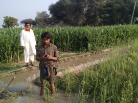
Students will learn about how NASA’s Earth observing satellites are helping us better understand Earth’s freshwater resources and help farmers with agriculture.

Primary Topic:
Subtopics:
Type:
Keywords:
Summary:
Students will learn about how NASA’s Earth observing satellites are helping us better understand Earth’s freshwater resources and help farmers with agriculture.

Primary Topic:
Subtopics:
Type:
Standards:
Keywords:
Summary:
The water cycle may seem simple on the surface, but there are many different ways to move through the process. This page has a few different versions of a Water Cycle Dice game to teach students about the complexities of water in Earth's system.

Primary Topic:
Subtopics:
Type:
Standards:
Keywords:
Summary:
GPM Project Scientist Gail Skofronick-Jackson explains why all snowflakes have six sides and how the Global Precipitation Measurement Mission can measure falling snow from space.

Primary Topic:
Subtopics:
Type:
Keywords:
Summary:
This lesson uses cubes as a way to graph precipitation data to compare the precipitation averages and seasonal patterns for several different locations. There are several variations to accommodate various ages and ability levels.
Primary Topic:
Subtopics:
Type:
Keywords:
Summary:
You will learn how we measure rain and snow from the ground and from space using satellites, and why we need to check the data using ground validation. This particularly relates to the OLYMPEX Field Campaign.
Primary Topic:
Subtopics:
Type:
Standards:
Keywords:
Summary:
The purpose of this lesson is to provide students with experience creating models of landforms and bodies of water. Students review the characteristics of landforms and bodies of water in an active game, and then make models of these.

Primary Topic:
Subtopics:
Type:
Standards:
Keywords:
Summary:
The purpose of this lesson is to expose elementary level students to the practice of “developing and using models” as students explore and identify landforms and bodies of water on a map of the world. It is anticipated that this lesson will take one hour.