Browse 9 - 12 Resources
Browse 9 - 12 Resources

Primary Topic:
Subtopics:
Type:
Summary:
A collection of resources exploring how NASA satellites like GPM can help monitor and predict Earth's climate.

Primary Topic:
Subtopics:
Type:
Keywords:
Summary:
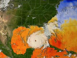
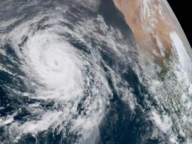
Learn all about hurricanes, the most violent storms on Earth, and how NASA uses satellites to study and understand these storms.
Primary Topic:
Subtopics:
Type:
Summary:
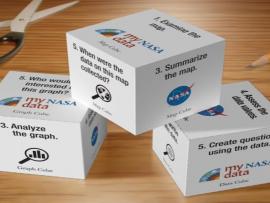
Using the My NASA Data Literacy Cubes will enhance students exploration of graphs, maps, and datasets to enrich their observations and inferences. The cubes offer an interactive and engaging way for participants to explore graphs, maps, and datasets.
Primary Topic:
Subtopics:
Type:
Summary:
Students will use various visualizations (i.e. images, charts, and graphs) to explore the energy exchange that occurs when hurricanes extract heat energy from the ocean.
Primary Topic:
Type:
Keywords:
Summary:
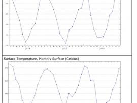
Students will analyze surface temperature and solar radiation data to construct explanations about the relationship of seasons and temperature to the amount of solar energy received on Earth’s surface.
Primary Topic:
Subtopics:
Type:
Keywords:
Summary:
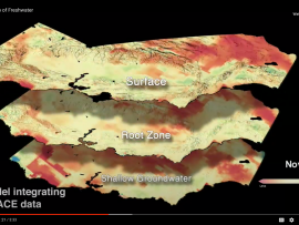
This My NASA Data lesson plan takes students through data from the GRACE satellite mission to help them understand where regions around the globe may experience a change in their freshwater availability.
Primary Topic:
Subtopics:
Type:
Summary:
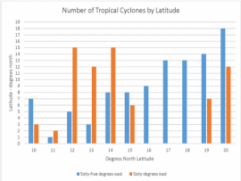
In this lesson, students will learn how to compare data displays related to tropical cyclones to identify patterns and relationships in the data. They will be able to create their own data displays or use the ones provided.
Primary Topic:
Subtopics:
Type:
Summary:
Learn all about hurricanes, the most violent storms on Earth.

Primary Topic:
Subtopics:
Type:
Keywords:
Summary:
Students will learn about how NASA’s Earth observing satellites are helping us better understand Earth’s freshwater resources and help farmers with agriculture.
Primary Topic:
Subtopics:
Type:
Keywords:
Summary:
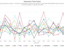
Did you know NASA has satellites that observe rain and snow all over the world? With this activity you can access NASA data to see how much precipitation was observed by satellites for your location any time from June 2000 to the present.