South Carolina
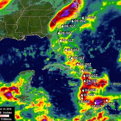
Deadly Hurricane Matthew's Total Rainfall
JacobAdmin
Wed, 10/12/2016
Hurricane Matthew devastated western Haiti and killed over 1,000 people. Matthew also took the lives of at least 37 deaths in the United States with 18 deaths occurring in the state of North Carolina. Flooding is still widespread in North Carolina. Some rivers in North Carolina such as the Tar and the Neuse are still rising. This rainfall analysis was accomplished using data from NASA's Integrated Multi-satelliE Retrievals for GPM (IMERG). IMERG is a unified U.S. algorithm that provides a multi-satellite precipitation product. IMERG is run twice in near-real time with the “Early” multi


