Maysak

IMERG Rainfall from Typhoons Bavi, Maysak and Haishen
From August 22 through September 7, 2020, NASA’s IMERG algorithm estimated rainfall from three typhoons as they passed over the Pacific Ocean, Japan, and Korea. According to NOAA's records, this was the only time since records have been kept starting in 1945 that the Korean peninsula saw three landfalling typhoons in a single year, let alone in two weeks. Each of the three typhoons--Bavi, Maysak, and Haishen--reached the equivalent of “major hurricane” status, meaning Category 3 or above on the Saffir-Simpson hurricane-intensity scale (shown here as a red in the hurricane track) along their

GPM Saw Deadly Maysak Approaching The Philippines

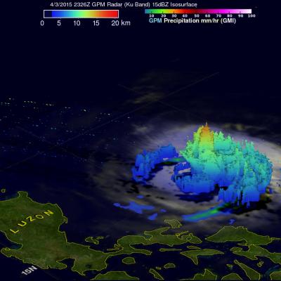
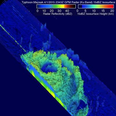
Typhoon Maysak caused the reported deaths five people in the Federated States of Micronesia and as a tropical storm killed seven others when it hit the the north-eastern Philippines. The GPM core observatory satellite passed above dissipating typhoon Maysak when it was approaching the Philippines on April 3, 2015 at 2326 UTC. An analysis of rainfall from GPM's Microwave Imager (GMI) showed that Maysak was dropping rain at a rate of over 69 mm (2.7 inches) per hour. Vertical wind shear was causing typhoon Maysak to weaken as it moved toward the Philippines but data from GPM's Dual-Frequency

Typhoon Maysak Starts Weakening

The GPM core observatory satellite passed above typhoon Maysak in the western Pacific Ocean on April 2, 2015 at 2343 UTC. GPM's Microwave Imager (GMI) found heavy rain in Maysak's northwestern side but the typhoon had weakened from it's peak intensity of over 130 kts (150 mph) to about 115 kts (132 kts) at the time of this satellite view. GPM's Radar (Ku Band) was used in this 3-D view to show vertical structure within typhoon Maysak. This view, looking toward the southwestern side of Maysak's eye, shows that the eye wall was eroding on that side. Vertical wind shear has contributed to typhoon

TRMM Satellite Makes Direct Pass over Super Typhoon Maysak

The Tropical Rainfall Measuring Mission satellite delivered a remarkable image of Super Typhoon Maysak on March 31. TRMM obtained an image straight over the top of a super typhoon with a double eye-wall, Super Typhoon Maysak, as it roared through the warm waters of the West Pacific south of Guam. This image with the TRMM Precipitation Radar or PR was taken at 14:15 UTC (10:15 a.m. EDT) on March 31, 2015 and shows the rain intensities within the very heart of Super Typhoon Maysak as it undergoes an eye wall replacement cycle. Mature, intense tropical cyclones can and often do undergo what is

TRMM And GPM See Typhoon Maysak

The TRMM satellite has been collecting valuable scientific data since November 1997. Early today the satellite collected rainfall data from recently formed typhoon Maysak as it flew directly above on March 30, 2015 at 0414 UTC. This image shows rainfall data collected with this orbit by TRMM's Microwave Imager (TMI) and Precipitation Radar (PR) instruments. With sustained winds of over 85 kts (98 mph) Maysak was a category two typhoon on the Saffir-Simpson hurricane wind scale. A little over eight hours later the GPM core observatory satellite also viewed typhoon Maysak on March 30, 2015 at