

Physical Validation
Physical validation activities collect targeted datasets that describe precipitation physics: the size, type, shape and number of raindrops throughout the air column from the cloud to the ground. Scientists use ground validation measurements to evaluate specific assumptions or hypotheses related to the physical behavior of precipitation, and the manner in which those characteristics are, or are not, well represented in a given retrieval algorithm. The goal of this validation process is to improve and fully develop physically-based precipitation retrieval algorithms. These algorithms are the first step to achieving GPM's applications objectives related to accurately characterizing rain and snow throughout many different types of precipitating systems.
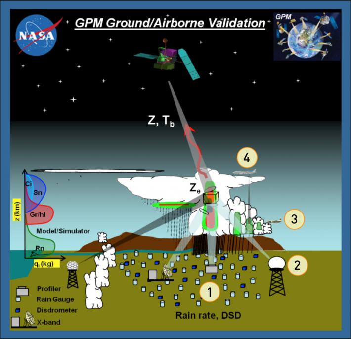
GPM ground validation uses a well-established strategy of overlapping field measurements of rain's physical properties. The measurements are made with dual-frequency radar and multi-frequency radiometer remote sensors, characteristic of GPM satellite instruments. These field measurements are conducted using:
- Ground level suites of high density disdrometer and rain gauge instruments to characterize precipitation properties and variability
- Multi-frequency/polarimetric radar and profiler observations of cloud microphysical properties and rainfall from the surface through the atmospheric column
- Direct in-situ and profiling aircraft measurements providing detailed particle microphysical information (sizes, shapes, types, numbers etc.) and evolution in the column as rain falls to the ground that can then be compared with radar observations
- High-altitude airborne (NASA ER-2, DC-8) dual-frequency radar and multi-frequency radiometers that mimic measurements made by the GPM Core and constellation satellites.