
Typhoon Roke makes Landfall in Central Japan
Roke, a once powerful Category 4 typhoon with sustained winds estimated at 115 knots (~132 mph), came ashore in central Japan Wednesday around 2 pm local time near Hamamatsu on the southeast coast of Honshu (about 200 km southwest of Tokyo) as a Category 1 typhoon. Roke began as a tropical depression ten days ago in the central Philippine Sea about 850 miles (~1370 km) south of Japan. For over a week, the cyclone meandered south of Japan with little change in intensity. Roke finally began to intensify on the 19th of September when it became a typhoon just east of the Ryukyu Islands and then took aim for central Japan. Roke continued to intensify as it moved off to the northeast in the direction of Honshu, briefly reaching Category 4 intensity on the 20th, before starting to weaken as it approached the Japanese coast.
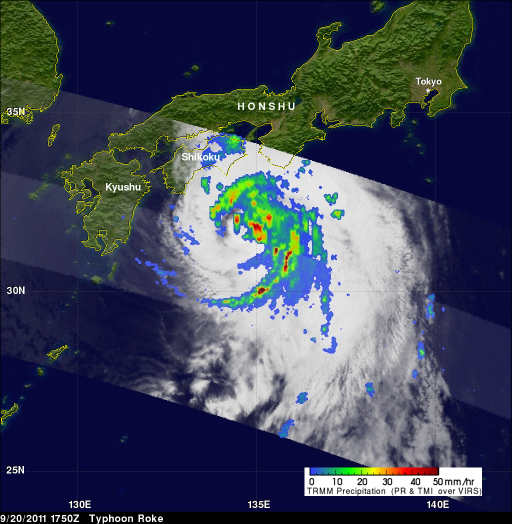
With its array of passive microwave and active radar sensors, the Tropical Rainfall Measuring Mission satellite (better known as TRMM) has been a valuable tool for observing tropical cyclones around the globe. TRMM captured this image of Roke as it was nearing the Japanese coast. The image was taken at 17:50 UTC 20 September 2011 (2:50 am 21 September local time) and shows the horizontal pattern of rain intensity within the storm. Rain rates in the center swath are based on the TRMM Precipitation Radar (PR), and those in the outer swath on the TRMM Microwave Imager (TMI). The rain rates are overlaid on visible and infrared (IR) data from the TRMM Visible Infrared Scanner (VIRS). TRMM reveals that Roke was becoming less organized as it approached Japan. Most of the rain, which is mainly moderate in nature (shown in green) is located on the east side of the storm with very little on the southwest side. The center is still fairly well defined but is no longer closed with a break in the eyewall evident to the southwest (note the incomplete ring of rainfall near the middle). In fact, Roke was in the process of weakening as its circulation was becoming disrupted by the effects of vertical wind shear.
So far 13 people have been reported missing or dead as a result of the storm, mostly due to river flooding, and hundreds of thousands are without power. After making landfall, Roke passed west of Tokyo before exiting the coast. Roke is expected to continue to race off to the northeast and remain just off the northeast coast of Hokkaido.
See the 20 September 2011 1750 UTC (kml) or the 19 September 2011 1351 UTC (kml) rainfall images in Google Earth .
At Goddard Space Flight Center flood potential calculations (from a hydrological model) are updated every three hours globally. Click here to see a movie that shows a history of flood potential estimates for Roke.