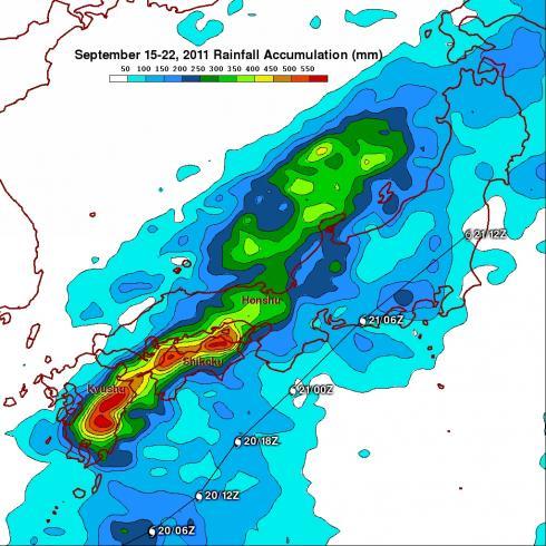
Typhoon Roke Brings Heavy Rains to Japan
Typhoon Roke, which made landfall as a Category 1 typhoon along the southeast coast of Honshu near the city of Hamamatsu (about 200 km southwest of Tokyo), was responsible for bringing heavy rains and flooding to most of Japan. Heavy rains actually began effecting parts of southern Japan well before the cyclone neared the coast as tropical moisture from Roke streamed northward into a stalled out frontal boundary that was draped across southern Japan. Japan is also very mountainous, which can enhance the effect. The Tropical Rainfall Measuring Mission or TRMM satellite is used to measure rainfall from space over the global Tropics using a combination of passive microwave and active radar sensors. For expanded coverage, TRMM can be used to calibrate rainfall estimates from other satellites. Rainfall estimates from the TRMM-based, near-real time Multi-satellite Precipitation Analysis (TMPA) at the NASA Goddard Space Flight Center are shown here for the period 15 to 22 September 2011 over and around Japan. TMPA rainfall estimates show a band of very heavy rain stretching northeastward from eastern Kyushu across Shikoku and into southern Honshu. Rainfall amounts within this band range from 300 mm (~12 inches, shown in green) to in excess of 550 mm (~22 inches, shown in red). Rainfall amounts along the actual track of Roke (shown by the thin black line), though significant, are substantially less, and generally range from 50 mm (~2 inches, shown in light blue) to over 150 mm (~6 inches, shown in blue) with occasional higher amounts. The reason for the lighter amounts with the actual passage of Roke was that the storm accelerated as it neared the coast and moved quickly across Honshu (appropriate storm symbols mark Roke's 6-hourly positions) before heading back out to sea. So far, 16 people have been reported dead or missing as a result of the storm.


