tropical storm

Hurricane Henriette To Move Over Colder Waters

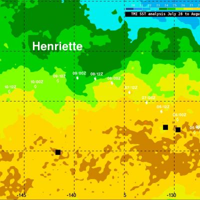
Hurricane Henriette, located a little over 1,770km (~1100 miles) east of Hawaii, was still intense with winds of 90kts (~103.5 mph) this morning. The National Hurricane Center (NHC) predicts that Henriette will weaken tomorrow as it moves over cooler waters and encounters west-southwesterly wind shear. Henriette's track was overlaid on a Sea Surface Temperature (SST) analysis that was derived from observations by the TRMM Microwave Imager (TMI) radiometer. Sea Surface temperatures have to be warmer than 26 °C for tropical cyclones to survive and this analysis indicates that hurricane Henriette

Tropical Storm Cimaron Brings Beneficial Rain To China

The image on the left used data captured by the TRMM satellite when it passed above tropical storm Cimaron on July 18, 2013 at 1132 UTC (~7:32 PM Local) just before it hit southeastern China. Rainfall was measured by TRMM's Microwave Imager (TMI) and Precipitation Radar (PR) instruments to be falling at a rate of over 183mm/hr (~7.2 inches) in a small area near Cimaron's center of circulation. TRMM PR found some radar reflectivity values greater than 55dBZ in these heavy rainshowers. Cimaron's track took it to the south of Taiwan yesterday. The rainfall anomaly analysis on the right was made

Tropical Storm 08W Becomes Stronger

Tropical storm MA-ON (08W), that developed east of the Marianas in the northern Pacific Ocean yesterday, has continued to become more powerful. MA-ON had wind speeds of about 35 kts (~40 mph) when the TRMM satellite saw the storm on 12 July 2011 at 0640 UTC and is predicted to gradually strengthen over the next five days. MA-ON is then expected to be a powerful typhoon with wind speeds of 95 kts (~109 mph) and be located in the open waters of the Pacific Ocean south of Japan. TRMM Microwave Imager (TMI) and Precipitation Radar (PR) data were used in the rainfall analysis being drawn on the

Tropical Storm BEATRIZ Forms Off Mexican Coast

Tropical depression 02E was upgraded to tropical storm Beatriz on 19 June 2011 at 1800 UTC (1100 AM PDT). The TRMM satellite flew over on the same date at 1105 UTC( 0400 AM PDT) obtaining data used in the image shown above. Beatriz was already well organized with TRMM's Microwave Imager (TMI) and Precipitation Radar (PR) data showing that thunderstorms were dropping heavy rainfall in a large area near the center of the forming storm. PR data revealed that some of these powerful storms were reaching heights above 15 km (9.3 miles).

Tropical Storm Adrian Seen Forming

Tropical Depression ONE-E was well on it's way to becoming tropical storm ADRIAN when the TRMM satellite flew over again on 7 June 2011 at 1717 UTC. Rainfall data from TRMM's Microwave Imager (TMI) and Precipitation Radar (PR) show that bands of rainfall were starting to get organized. A red tropical storm symbol shows the location of the future storm's center of circulation. TRMM's PR showed thunderstorm towers as high as 15 km (~9.3 miles) in rain bands west of ADRIAN's center.