Taiwan

Super Typhoon Usagi Threatens The Philippines and Taiwan

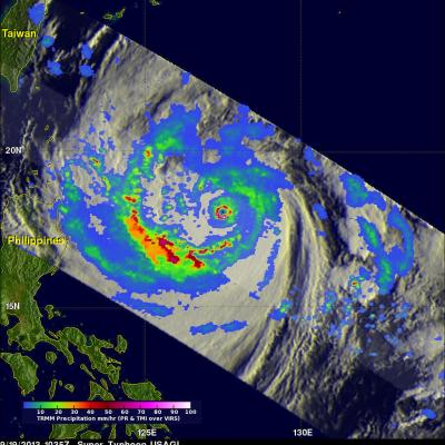
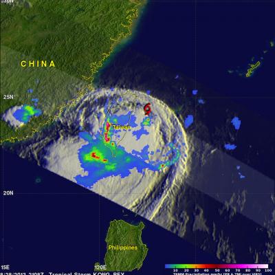
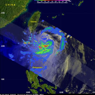
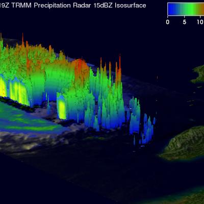
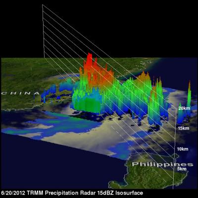
The most powerful typhoon of 2013 may affect the northern Philippines and southern Taiwan. What is now super typhoon USAGI formed in the open waters of the Philippine Sea about 1,000 km (~620 miles) east of the Philippines on September 16, 2013. USAGI rapidly intensified and became a typhoon yesterday. Super Typhoon USAGI had estimated maximum winds of close to 140kts (~161 mph) when the TRMM satellite had an excellent view on September 19, 2013 at 1035 UTC. A precipitation analysis from TRMM's Microwave Imager (TMI) and Precipitation Radar (PR) instruments is shown on the left overlaid on an

TRMM Sees Heavy Rain Over Taiwan

The TRMM satellite flew directly above western Taiwan on August 28, 2013 at 2108 UTC when tropical storm Kong-Rey was dropping enormous amounts of rain. Flooding from torrential rainfall with totals of over 500mm (~19.7 inches) have been reported in western Taiwan. This rainfall analysis from TRMM's Microwave Imager (TMI) and Precipitation Radar (PR) instruments revealed that precipitation was falling at a rate of over 205mm/hr (~8 inches) in intense bands of rain over southwestern Taiwan. Tropical storm Kong-Rey's location when TRMM flew over is shown with a red symbol. This TRMM orbit also

Tropical Storm Kong-Rey To Hit Taiwan Then Japan

Tropical storm Kong-Rey formed in the western Pacific Ocean east of the Philippines on August 26, 2013. Kong-rey passed to the northeast of the Philippines and is predicted to cross over northeastern Taiwan tomorrow. In about three days it is then predicted to be the first tropical cyclone of 2013 to hit southern Japan. The TRMM satellite had an early morning view of tropical storm Kong-Rey on August 27, 2013 at 2203 UTC (~6:03 AM local time). A precipitation analysis from TRMM's Microwave Imager (TMI) and Precipitation Radar (PR) instruments is shown on the left above overlaid on an enhanced

Weaker Typhoon Soulik Heads Towards Taiwan

TRMM satellite again flew above weakening typhoon Soulik on July 11, 2013 at 2119 UTC. Data from TRMM's Microwave Imager (TMI) and Precipitation Radar (PR) instruments show that Soulik had weakened considerably. The eye diameter was shown to be much greater than when TRMM passed over super typhoon Soulik about 7 hours earlier. This TRMM Precipitation Radar 3-D view (from the northwest) shows typhoon Soulik east of Taiwan. The structure of Soulik's large eye is clearly shown by this TRMM PR slice through the weakening typhoon. Soulik is predicted by the Joint Typhoon Warning Center (JTWC) to be

Tropical Storm Talim's Heavy Rainfall Over Taiwan

Tropical storm Talim has produced torrential rainfall over southern Taiwan as it pumped warm moist air from the South China Sea over mountainous terrain. The TRMM satellite flew over tropical storm Talim in the Taiwan Strait on 20 June 2012 at 0140 UTC. TRMM Precipitation Radar (PR) data from this orbit shows that tropical storm Talim was dropping rainfall at a rate of almost 50mm/hr over Taiwan. TRMM data captured with that orbit shows that the most intense rainfall of over 50mm/hr (~2 inches) was located over the Strait Of Taiwan. Flash flooding and landslides are probable in southern Taiwan