Japan

GPM Sees Intensifying Typhoon Lan Heading Toward Japan

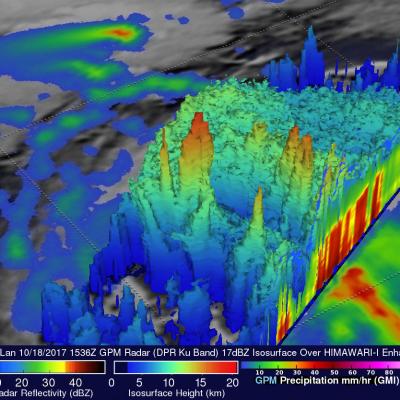
Tropical depression twenty five (TD25W) formed in the western Pacific Ocean west of Yap on October 15, 2017. After that the intensifying tropical cyclone moved into the Philippine Sea. Tropical storm Lan recently moved toward the north and was upgraded to typhoon Lan. Maximum sustained wind speeds today (October 19, 2017) were estimated to have reached 75 kts (~86 mph). This wind speed makes it a category one on the Saffir-Simpson hurricane wind scale. Extremely warm ocean waters (30-31 degrees Celsius) along Lan's path are providing fuel for further intensification. On October 18, 2017 at

GPM Sees Typhoon Talim Threatening Islands Of Japan

The Joint Typhoon Warning Center (JTWC) predicts that typhoon Kalim in the western Pacific Ocean will intensify and threaten the islands of southern Japan in the the new three days. Environmental conditions such as low vertical wind shear and warm sea surface temperatures are favorable for Talim's intensification. Talim's winds are expected to increase to a peak of 115 kts as it re-curves toward the the Japanese island of Kyushu. The GPM core observatory satellite scanned the western side of typhoon Talim on September 13, 2017 at 0216 UTC. GPM's Microwave Imager (GMI) instrument collected data

GPM Sees Typhoon Malakas Starting To Batter Japan

September 19, 2016 0046 UTC September 19, 2016 1031 UTC After causing high winds and heavy rainfall over northern Taiwan, typhoon Malakas is now starting to batter the islands of southern Japan. The GPM core observatory satellite passed above typhoon Malakas twice on September 19, 2016. The first time was at 0046 UTC when the typhoon was starting to cause light to moderate rainfall over the island of Kyushu. At 1031 UTC GPM showed that moderate to heavy rainfall was moving over Kyushu and the typhoon's appearance had changed significantly. The change in appearance was credited to increased

GPM Gets a Ton of Kilo

Submitted by JacobAdmin on Mon, 09/21/2015
Video Embed

The Global Precipitation Measurement (GPM) mission core satellite provided many views of Tropical Cyclone Kilo over its very long life. GPM is a satellite co-managed by NASA and the Japan Aerospace Exploration Agency that has the ability to analyze rainfall and cloud heights. GPM was able to provide data on Kilo over its 21 day life-span. 

https://www.youtube.com/watch?v=8eIwMXnU8IA&feature=youtu.be
A narrated visualization of Typhoon Kilo. Click here for a full transcript. Click here to download this video in high resolution from the NASA Goddard Scientific Visualization Studio. The Global Precipitation Measurement (GPM) mission core satellite provided many views of Tropical Cyclone Kilo over its very long life. GPM is a satellite co-managed by NASA and the Japan Aerospace Exploration Agency that has the ability to analyze rainfall and cloud heights. GPM was able to provide data on Kilo over its 21 day life-span. The GPM core observatory satellite flew over Kilo on August 25, 2015 at...

Wednesday September 9, 2015 Japan's Torrential Rain Measured With IMERG

Over the past week Japan has experienced extreme rainfall that resulted in flooding, landslides and many injuries. A nearly stationary front that was already moving over Japan caused much of the rain but tropical storm ETAU also interacted with the front and magnified the scale of the deluge. Heavy rainfall led to the evacuation of over one million people. This rainfall analysis from space was generated using NASA's Integrated Multi-satellite Retrievals for GPM (IMERG) data. It shows rainfall total estimates for Japan during the seven day period from September 2-9, 2015 when Japan was getting

Weaker Typhoon Nangka Threatens Japan

Typhoon Nangka was a super typhoon with winds of 135 kts (155 mph) over the open waters of the Pacific Ocean last week. Nangka is predicted by the Joint Typhoon Warning Center (JTWC) to have weakened to barely typhoon intensity with winds of less than 65 kts ( 75 mph) before hitting Japan on July 16, 2015. The GPM core observatory satellite passed above early in the life of the typhoon on July 6, 2015 when Nangka was east-southeast of Guam. At that time Nangka had formed a nearly perfectly circular eye that contained powerful storms reaching to altitudes of close to 17km (10.5 miles). GPM flew
GPM Scans Typhoon Phanfone
Animation revealing a swath of GPM/GMI precipitation rates over Typhoon Phanfone. The camera then moves down closer to the storm to reveal DPR's volumetric view of Phanphone. A slicing plane dissects the Typhoon from south to north and back again, revealing it's inner precipitation rates. Shades of blue indicate frozen precipitation (in the upper atmosphere). Shades of green to red are liquid precipitation which extend down to the ground. Download in Hi-Res from the Scientific Visualization Studio On October 6, 2014 (0215 UTC) the Global Precipitation Measurement (GPM) mission's Core...
GPM Scans Typhoon Phanfone
Typhoon Phanfone
JacobAdmin Wed, 10/15/2014
Image Caption
Print resolution still of Typhoon Phanfone being scanned through the center of the DPR data showing the inner volumetric rain rates. Note: Tokyo is immediately to the left of the scan.
Typhoon Phanfone Batters And Soaks Japan JacobAdmin Mon, 10/06/2014
Phanfone was a powerful super typhoon with sustained wind speed estimated at 130 kts ( 150 mph) as it approached Japan but had weakened to a category one typhoon with sustained winds of about 70 kts (81 mph) as is passed near Tokyo. Phanfone's track and locations when the tropical cyclone was near Japan are shown overlaid in white. The TRMM- based, near-real time Multi-satellite Precipitation Analysis (TMPA) at the NASA Goddard Space Flight Center has been measuring the distribution of precipitation over the tropics. TMPA based rainfall totals are shown here for the period from September 28 to