Hurricanes

IMERG totals from hurricane sally
The northern Gulf Coast has seen its share of storms this busy hurricane season. At the end of August, then Tropical Storm Marco brought heavy rains to parts of the Florida Panhandle while western Louisiana took a direct hit from the much more powerful Category 4 Hurricane Laura. Now, just over 3 weeks since Laura made landfall, the northern Gulf Coast was struck again, this time by Hurricane Sally. Though not as powerful as Laura, the still rather strong Sally behaved more like Marco. But, while Marco was largely sheared apart with most of the rain well northeast of the center as it slowed
IMERG Rainfall Totals from Hurricanes Marco and Laura
The northern Gulf Coast, specifically Louisiana, saw two tropical cyclones make landfall in the same week just days apart. The two systems, however, could not have been more different when they arrived. Despite forming a day later, Marco was the first system to make landfall on the Gulf Coast. Marco originated from a tropical easterly wave that was moving from the central to the western Caribbean. After becoming a tropical depression (TD) on the 20th of August, TD #14 turned northwestward the following day as it approached the coast of Central America and moved into the northwest Caribbean
GPM Overpass of Hurricane Laura 8/27/20
After crossing western Cuba, Tropical Storm Laura emerged into the Gulf of Mexico where warm water, low wind shear and a moist environment made conditions ideal for intensification. As it made its way through the Gulf of Mexico Laura strengthened - from a category 1 hurricane with sustained winds of 75 mph on the morning of Tuesday August 25th, to a powerful category 4 storm, with sustained winds of 150 mph on the evening of Wednesday August 26th - an increase of 75 mph in just 36 hours. At this point Laura was nearing the coast of western Louisiana, and made landfall near Cameron, Louisiana
GPM Overpass of Hurricane Laura 8/26/20 10:00pm CT
Hurricane Laura began as a tropical depression on August 21st near the U.S. Virgin Islands, and over the next several days rapidly intensified to a dangerous category 4 hurricane at it moved towards the U.S. Gulf Coast. Laura made landfall as strong category 4 hurricane near Cameron, Louisiana shortly after midnight on August 27, 2020, bringing extreme rainfall, storm surge, and winds up to 150 mph. The NASA / JAXA GPM Core Observatory satellite flew over Hurricane Laura shortly before it made landfall at 10:00pm CT on Wednesday, August 26th, then again at 7:42am CT on Thursday, August 27th
Hurricane Laura on August 27, 2020
Update on August 28, 2020: During its approach to Louisiana, Hurricane Laura dramatically intensified from Category 2 to 4 (105 mph to 150 mph) between at 1AM and 7PM Central Time (CDT) on August 26, 2020. In the updated movie below, the precipitation falling from Laura is shown through 10:30PM CDT, August 27, as estimated by NASA's IMERG algorithm. To open the animation in a separate window, click here . On August 26, Laura became the first North Atlantic hurricane to reach "major hurricane" status this year, meaning that it reached category 3 on the Saffir-Simpson hurricane-intensity scale
Hurricane Isaias Impacts the US East Coast
From July 29 to August 5, 2020, NASA’s IMERG algorithm observed tropical storm Isaias’ rainfall over the Caribbean and large parts of the Eastern US. This animation shows the IMERG rain rates in green shading as Isaias tracked from the tropical Atlantic into the Caribbean, then northward along the Atlantic coast and into New England. The yellow line shows the location of Isaias' low-pressure center, as tracked by the National Hurricane Center and smoothed in time here for the animation.
IMERG Hurricane Hanna 7-27-20 cropped
Hanna formed from a westward propagating tropical easterly wave that entered the southeast corner of the Gulf of Mexico on Tuesday July 21st. The wave provided a focus for shower and thunderstorm activity, which then led to the formation of an area of low pressure over the central Gulf of Mexico. The National Hurricane Center (NHC) found that this low had developed a closed circulation by the evening of Wednesday July 22nd, making it Tropical Depression #8. Over the next 24 hours, the depression slowly organized and intensified over the central Gulf before reaching tropical storm intensity on
GPM Hurricane Douglas 7-25-20
Hurricane Douglas continued to approach the Hawaiian islands during this GPM overpass early in the morning (02:11 UTC) of July 25, 2020. Douglas had previously strengthened to a Category 4 hurricane the day before, but had substantially weakened over cooler waters throughout the day. Regardless, the GMI and DPR instruments recorded rain rates near 50 millimeters/hour (~2 inches/hour) near Douglas` center. The Central Pacific Hurricane Center advised residents of Hawaii to expect hurricane-strength winds and rainfall starting Saturday evening and lasting through Monday. View fullscreen in STORM

GPM IMERG Measures Hurricane Dorian's Rainfall from the Caribbean to Canada

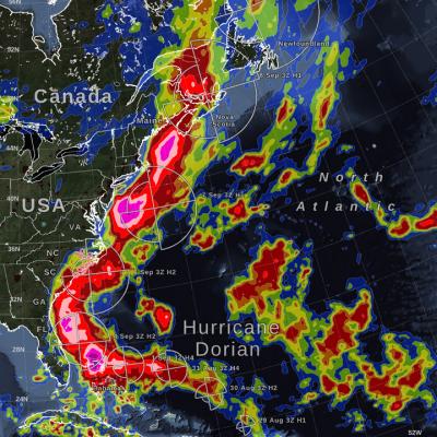
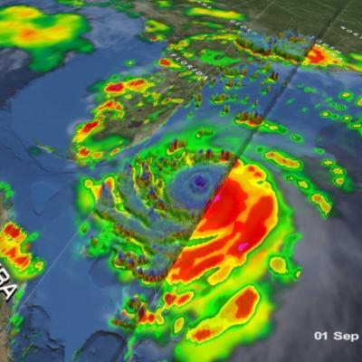
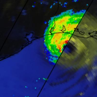
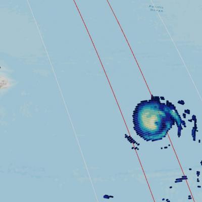
Hurricane Dorian (2019) brought heavy rain to the Caribbean, along the US East Coast, and up to Canada. NASA satellite-based precipitation estimates tracked the storm throughout its lifetime, as shown by the sequence of images below. September 3, 2019: Hurricane Dorian over Grand Bahama and Abaco Islands In the early hours of Tuesday, September 3, Hurricane Dorian had been stationary over the island of Grand Bahama for 18 hours, most of the time as a category 5 hurricane. Storm-total rain accumulation over parts of Grand Bahama and Abaco islands have exceeded 24 inches according to NASA
GPM Overpass of Hurricane Dorian
Tropical cyclones, known as hurricanes in the western hemisphere, can bring damaging high winds, storm surge, and flooding rainfall to the coastal communities they hit. Satellite instruments - and the detailed near real-time atmospheric data that they provide - have revolutionized the way we see hurricanes and other disasters as they happen. But it’s about more than just seeing. NASA, working with counterparts at NOAA, FEMA, and elsewhere are sharing ever more precise data to aid local communities in coping with disasters. With better information, emergency responders have the tools to make...