Hurricanes

Hurricane Rina Threatens the Yucatan

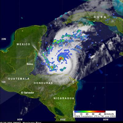
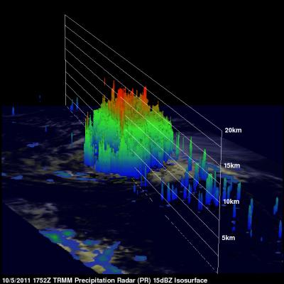
After a two-week period without any storms, the 2011 Atlantic hurricane season has picked up with the arrival of Hurricane Rina. Rina began as a tropical depression on October 23rd in the western Caribbean. Like many storms that form later in the season, Rina's formation was influenced by a midlatitude front that had penetrated deeper into the Tropics over warm water. These fronts can provide a focus for showers and thunderstorms that can eventually evolve into a tropical cyclone. During the peak of hurricane season in late August and September, a lot of storms form out over the central

Tropical Systems bring Heavy Rain to Mexico and Central America

Within just the past week, the East Pacific has seen a resurgence in tropical activity with the formation of three tropical systems: two hurricanes and a depression. Two of the systems, the two that would go on to become hurricanes, formed on the evening and night of 5 October 2011. The first was TD #10E, the 10th tropical depression of the season in the East Pacific. It formed about 1000 km (~625 mi) south of the Mexican coast and later strengthened into Hurricane Jova. Jova intensified to a Category 3 hurricane before eventually making landfall as a Category 2 storm on Wednesday October 12th

Hurricane Jova Starting to Affect Mexico

The TRMM satellite passed above hurricane Jova off the west coast of Mexico on 11 October 2011 at 1700 UTC. The image above shows a rainfall analysis from TRMM's Microwave Imager (TMI) and Precipitation Radar (PR) overlaid on a combination visible and infrared image from Visible and InfraRed Scanner (VIRS). This TRMM orbit shows that rainfall bands from the powerful category three hurricane were starting drench coastal Mexico.

Philippe Becomes a Hurricane

The National Hurricane Center (NHC) upgraded Philippe to a hurricane at 1500 UTC (11 AM EDT) on Thursday 6 October 2011. Earlier TRMM Microwave Imager (TMI) data from the 6 October 2011 at 0024 UTC view shows that tropical storm Philippe's center of circulation had become better defined with an eye wall forming. The TRMM satellite also had an excellent look at Philippe earlier on Wednesday 5 October 2011 at 1752 UTC (1:52 PM EDT). TRMM's Precipitation Radar (PR) scanned directly over Philippe and revealed that Philippe had bands of intense rainfall around the southeast side of the center of

TRMM Sees CAT 4 Ophelia

Ophelia was a very powerful category four hurricane on the Saffir-Simpson scale with winds of over 115 kts (~132 mph) when TRMM passed over head on 2 October 2011 at 0049 UTC. The Infrared image from that orbit shows that Ophelia had a small clear eye as it was passing well to the east of Bermuda. TRMM's Microwave Imager (TMI) and Precipitation Radar (PR) data revealed that heavy rainfall was located in the northern side of the eye wall.

Ophelia Becomes a Hurricane

The TRMM satellite saw tropical storm Ophelia on 29 September 2011 at 2008 UTC ( 4:08 PM EDT) shortly before the storm was upgraded to a hurricane by the National Hurricane Center (NHC). An analysis of rainfall from TRMM's Microwave Imager (TMI) and Precipitation Radar (PR) data shows that Ophelia was developing an eye with powerful thunderstorms located in the northwestern side of the forming eye wall. On Friday 30 October 2011 Ophelia further intensified to become a powerful category three hurricane on the Saffir-Simpson scale with winds of 100kts (~115 mph). The NHC has predicted that this

Irene Drenches the Northeastern United States

The TRMM-based, near-real time Multi-satellite Precipitation Analysis (MPA) at the NASA Goddard Space Flight Center monitors rainfall over the global tropics. The analysis above shows MPA rainfall totals for the period from 20-29 August 2011. Hurricane Irene was dropping tremendous amounts of rainfall over the eastern United States during a part of this period and caused flooding from the Carolinas to the northeastern states. The heaviest rainfall totals of over 225 mm (~8.9 inches) were located in North Carolina where Irene first made landfall in the United States. Very heavy rainfall

TRMM Views Irene Again Over Cape Hatteras

The TRMM satellite had another very good daytime view of hurricane Irene on 27 August 2011 1750 UTC (1:50 PM EDT). The rainfall analysis shown on the right was derived from TRMM's Microwave Imager (TMI) and Precipitation Radar (PR) data. It clearly shows the location of Irene's eye and the intense rainfall falling over Cape Hatteras east of the eye. Click here to see this image in Google Earth (kml).

TRMM sees Irene Approaching The Carolinas Coast

The TRMM satellite saw hurricane Irene again on 26 August 2011 at 2023 UTC (4:23 PM EDT) when winds had weakened to about 85 kts (~98mph). This TRMM pass showed no clear eye but bands of heavy rainfall north of the center. Irene was predicted by the NHC to weaken a little more before coming ashore in North Carolina. See the 26 August 2011 2023 UTC image in Google Earth (kml).

Hurricane Irene Passes Through Bahamas and Heads Toward Cape Hatteras

Hurricane Irene was seen affecting the Bahamas twice during the daytime by the TRMM satellite on Thursday 25 August 2011 at 1624 UTC ( 12:24 PM EDT) and at 2118 UTC ( 5:17 PM EDT). A rainfall analysis from TRMM's Microwave Imager (TMI) data shows that Irene's eye had moved to the north of the islands of the Bahamas by the second pass. TRMM' Precipitation Radar (PR) data shows that at this time Irene contained bands of intense thunderstorms dropping rain at the rate of over 50 mm/hr (~2 inches) north of the hurricane's eye. Irene weakened slightly today (Friday) from a category 3 to a strong