heavy rain

Severe Weather In Tornado Alley And Eastward JacobAdmin Fri, 04/29/2016
Severe spring thunderstorms frequently spawned tornadoes from the Gulf Coast north and eastward during the past week. Gulf moisture clashing with frontal systems moving over the United States provided much of the fuel for intense showers and severe thunderstorms. Flash flooding was often the result of the sudden onset of extremely heavy rainfall. Over 305 mm (12 inches) of rain was reported in southern Mississippi in a few hours one morning on April 28, 2016. NASA's Integrated Multi-satellitE Retrievals for GPM (IMERG) data were used to estimate the amount of rain that fell from April 22-29

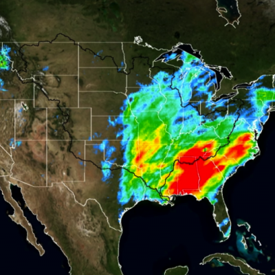
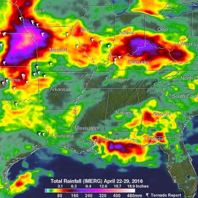
Slow-moving Frontal System Brings Heavy Rains, Flooding to Parts of Texas

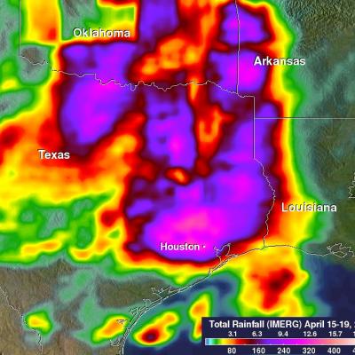
A slow-moving frontal system associated with a stagnant upper-air pattern set the stage for heavy rains and flooding early this week from East Texas all the way up through the Central and Northern Plains. The hardest hit region was in and around the Houston area. On Monday, the National Weather Service reported that Houston International Airport broke its all time daily rainfall record with 9.92 inches of rain. Elsewhere in Harris County, over 17 inches of rain was recorded as of Monday evening. The main culprit was a stationary upper-level low pressure center spinning over the Central Rockies

Torrential Rain Over South Measured From Space

Extremely heavy rain fell over the southern United States during the past week. A slow moving area of low pressure pumped moisture from the Gulf Of Mexico causing torrential rain that resulted in wide spread flooding in states from Texas to Tennessee. Over 24 inches of rain was reported in Monroe, Louisiana. Over 4,958 homes in Louisiana were reportedly damaged by the flooding. Strong winds accompanying intense thunderstorms also toppled trees in Mississippi and Louisiana. A simulated 3-D animation of NASA merged satellite rainfall analysis (TMPA) using data collected from March 7-14, 2016

GPM Views Severe Weather And Heavy Rain in the U.S.

The GPM satellite flew above storms in the southwestern United States this morning (March 9, 2016) at 1011 UTC (5:11 CST). Severe weather has been moving slowly through this area for the past couple days. Two tornadoes developed in north central Texas yesterday morning (March 8, 2016). This morning rain was measured by GPM's Dual-Frequency Precipitation Radar (DPR) instrument falling at the extreme rate of over 148 mm (5.8 inches) in one powerful storm over eastern Texas. GPM's radar (DPR Ku Band) found that a few thunderstorm tops in this area were reaching altitudes above 13.7 km (8.5 miles)

IMERG Analyzes El Niño Fueled California Storms

After a break in February, El Nino fueled storms have started pounding California as they move in from the Pacific Ocean. Northern California has been especially hard hit with heavy rainfall and strong winds being reported. Heavy rainfall north of Sacramento caused flooding that killed a woman in Olivehurst, California. Rain and snowfall in the Sierra Nevada mountains may help to alleviate the long lasting California drought. An analysis of total precipitation from February 29 to March 7, 1016 was accomplished using data collected by NASA's Multi-satellitE Retrievals for GPM (IMERG). This

Extreme Precipitation Measured From Space

For over a week the weather over the continental United State's has been punctuated by extreme events. Automobiles were thrown around on January 27, 2016 by tornadoes that hit southern Florida. On January 31 a winter storm with heavy rain, strong winds and isolated thunderstorms hit southern California killing at least one person. There were numerous reports of hail with these storms ranging from pea sized to up to an inch in diameter. Powerful winds with these storms also brought down trees and power lines. A blizzard that followed the Democratic and Republican caucuses in Iowa dropped over
Storm Brings Heavy Precipitation to Northeast
UPDATE 1/23/2016 5:00pm ET On January 23, 2016 at 1239 UTC (7:39 AM EST) the GPM core observatory passed above the deadly winter storm that was burying the Northeast under a deep layer of snow. As GPM passed above a band of snow was shown approaching the island of Manhattan. The winter storm was predicted to dump near record snowfall in New York city. GPM's Microwave Imager (GMI) and Dual-frequency Precipitation Radar (DPR) instruments showed massive amounts of moisture being transported from the Atlantic Ocean over states from New York westward through West Virginia. GPM's Radar instruments...

Rainy Weather Over Pacific Northwest Measured From Space

Stormy weather moving in from the Pacific Ocean has frequently affected the Pacific Northwest over the past week. Moisture moving over the Washington and Oregon coasts has been transformed into snow at colder and higher elevations in the Cascades. Coincidentally a field campaign called The Olympic Mountain Experiment (OLYMPEX) is being led by NASA in the Olympic Peninsula of Washington State from November 2015 through February 2016. An analysis of precipitation that occurred in the Pacific Northwest during the period from January 12-19, 2016 is shown here. This precipitation analysis from
Rainfall Floods the Mississippi River
A series of winter storms brought more than 20 inches of rainfall to the Midwest and southeastern United States in December 2015. Massive flooding followed throughout both the regions. An animation of rainfall data from those storms was created at NASA's Goddard Space Flight Center in Greenbelt, Maryland. This animation shows the accumulation of rainfall over the United Stated during December 2015, from the IMERG precipitation dataset. The black outline indicates the Mississippi-Missouri River basin. This version has been edited to only show the periods of significant rainfall during the month...

GPM 2015: One Year of Storms

Submitted by JacobAdmin on Mon, 01/11/2016
Video Embed

As we enter the new year, take a look back at the snowstorms, tropical storms, typhoons, hurricanes and floods captured and analyzed by the Global Precipitation Measurement (GPM) mission from around the globe during 2015. 

The complete list of storms by date and location are as follows:

1. New England Nor’easter – January 26 – New England, USA
2. Snowstorm – February 17 – Kentucky, Virginia and North Carolina, USA
3. Tornadic Thunderstorms in Midwest – March 25 – Oklahoma and Arkansas, USA