Rainfall Near ARANI Subsides
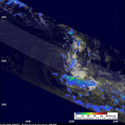
The image above shows subtropical cyclone ARANI as the TRMM satellite passed over head on 17 March 2011 at 0958 UTC. TRMM Microwave Imager (TMI) and Precipitation Radar (PR) data from that orbit show that moderate to heavy rainfall was only occurring to the southeast of ARANI at that time. TMI and PR rainfall data were overlaid on a combination visible and infrared image that used TRMM Visible and InfraRed Scanner (VIRS) data. Visible low level clouds from this image (shown in shades of yellow) are the only evidence for the location of ARANI's center of circulation. Click here to see earlier