PMM Featured Articles Promo

This content will appear in the "Featured Articles" slideshow on the PMM front page.

Screenshot of mentors and participants (mentees) during the last session of the 2022 Mentorship Program.
The GPM Applications Team in collaboration with the University of Coimbra created the GPM Mentorship Program to support new users from established and underrepresented communities and provide tailored hands-on learning experiences in using GPM data for applications . The goal of the program is to provide an overview of using state-of-the-art satellite-based precipitation estimates, and to provide users their first experience of applying GPM data to support real-world problems. The 2022 initiative is the first edition of the mentorship program.
IMERG analysis of Hurricane Ian
On Sept. 30, 2022, Hurricane Ian was approaching South Carolina, which was one day after Ian finished its west-to-east crossing of Florida. NASA has been estimating Hurricane Ian's precipitation over land and ocean, which complements the array of detailed observations collected by NOAA and other agencies of Ian's impact over land.
GPM overpass of Hurricane Ian on Sept. 26, 2022
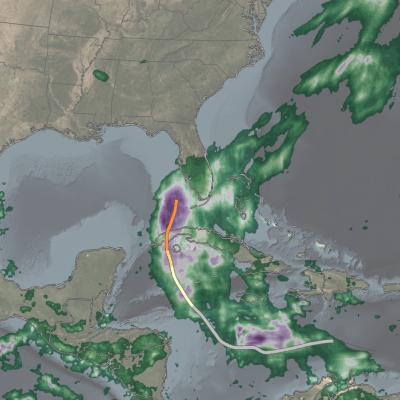
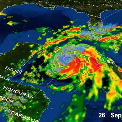
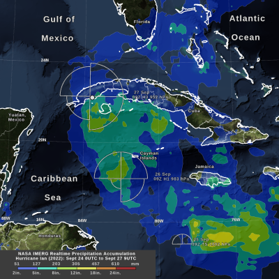
Hurricane Ian became one of the strongest hurricanes on record to strike Florida when it made landfall Wednesday, Sept. 28th, 2022, around 3:10 pm (EDT) as a Category 4 storm near Cayo Costa, FL, about 20 miles west-southwest of Punta Gorda on Florida’s southwest coast. This same area was hit hard by Hurricane Charley in 2004, which also made landfall as a strong Category 4 storm. Both storms passed over and were intensified by the deep, warm waters of the southeastern Gulf of Mexico. Ian originated from a tropical easterly wave that propagated westward off the coast of Africa across the
IMERG precipitation totals from Hurricane Ian
Hurricane Ian formed in the Caribbean Sea on Sept. 26, 2022. Ian intensified to Category 3 hurricane on the Saffir-Simpson scale by the time it made landfall in western Cuba early the next day. NASA's near real-time IMERG algorithm was used to estimate the precipitation from Ian during its formation and intensification. IMERG shows that Ian's largest rainfall accumulation so far, over 12 inches, occurred while it was only a tropical storm and not yet a hurricane. The National Hurricane Center provided an estimate of the distance that tropical storm-force winds extended from Ian's low-pressure
GPM overpass of Hurricane Fiona on Sept. 23, 2022.
After leaving the Caribbean, Hurricane Fiona became both the strongest and the first major hurricane of the 2022 Atlantic hurricane season as it made its way northward through the western Atlantic. Fiona began as an African easterly wave that moved across the tropical Atlantic in the direction of the Caribbean. While still about 800 miles east of the Leeward Isles, this wave organized into a tropical depression on Sept.14th. Later that same day, the depression strengthened and became Tropical Storm Fiona. Fiona remained a moderate tropical storm as it passed through the Leeward Isles on the
IMERG precipitation estimates from Hurricane Fiona
In September 2022, Hurricane Fiona had impacts in the Caribbean, on Bermuda, and in Canada. NASA's satellites and science algorithms helped to monitor this hurricane in near real time.
GPM overpass of Typhoon Nanmadol
Super Typhoon Nanmadol became one of the strongest typhoons to threaten Japan since records began in 1951. Nanmadol began as a tropical disturbance, basically an area of active thunderstorms, on September 11th southeast of Iwo Jima about midway between Tokyo and Guam. After moving to the southwest for 2 days, this disturbance became better organized and formed into a depression on the 13th. The system then made a counterclockwise loop, moving first back to the northeast before turning back again towards the west. Over this time, the system slowly intensified, becoming Tropical Storm Nanmadol
Screenshot of the High-Impact Weather Assessment Toolkit (HIWAT),
Bangladesh has a long history of deadly and costly storms. Because these storms are so localized, they can be notoriously difficult to forecast, especially without access to the most advanced weather prediction technology. Researchers have created a new tool to boost the country’s ability to forecast severe weather. The SERVIR program - a joint initiative of NASA, USAID, and leading geospatial organizations in Asia, Africa, and Latin America - and the Bangladesh Meteorological Department ( BMD ) recently launched the High-Impact Weather Assessment Toolkit ( HIWAT ), a web-based tool that
IMERG totals from twin cyclones in the Indian Ocean
Over the past several days, a relatively rare event occurred in the eastern Indian Ocean: the formation of “twin” tropical cyclones. Tropical Cylones Karim and Asani formed at nearly the exact same time (06:00 UTC and 06:30 UTC, 12:00 pm and 12:30 pm local time) on May 7 on opposite sides of the Equator. Karim officially formed first in the southern hemisphere (SH) followed immediately by Asani in the northern hemisphere (NH). At first glance, the cyclones appear to be mirror images of one another with Asani rotating counterclockwise in the NH and Karim rotating clockwise in the SH roughly
IMERG rainfall totals in South Africa, April 5 - 18, 2022.
An upper-level area of low pressure tapped into the warm waters of the South Indian Ocean to bring heavy rains and flooding to parts of South Africa during the second week of April. The event unfolded when an upper-level trough of low pressure embedded within the midlatitude westerlies traversed the southern part of Africa from west to east. As the trough approached the east coast of South Africa, an area of low pressure became detached from the main flow, this “cut off” low then drifted over the warm waters of the Agulhas Current, which channels warmer waters from the tropical Indian Ocean