Historic Hurricane Hilary Brings Heavy Rain and Flooding to the U.S. Southwest
Hurricane Hilary is being hailed as a historic storm after becoming the first tropical storm to hit California since Sept. 24, 1939. The storm has had a large impact on the region - in addition to gusty winds, Hilary’s rains have resulted in widespread flooding, landslides, washed out roads and numerous other closures.
Like most East Pacific tropical cyclones, Hilary originated from a westward propagating tropical wave that crossed over Central America from the western Caribbean into the eastern Pacific. Known as “African easterly waves”, these are the same waves that emerge off the coast of Africa and can act as seedlings for tropical storms and hurricanes that form out over the Atlantic. The wave associated with the formation of Hilary moved into the East Pacific on Aug. 12, but it wasn’t until the morning of Aug. 16 that the system had developed enough of a circulation to be declared a tropical storm. After doing so Hilary quickly gathered strength, and the next day on Aug. 17 underwent a rapid intensification cycle, becoming a hurricane at 6:00 am MDT, a Category 2 hurricane by 12:00 pm, a Category 3 hurricane by 6:00 pm, and a Category 4 hurricane by midnight. At this point Hilary was about 425 miles due south of Cabo San Lucas, Mexico, on the southern tip of the Baja California peninsula and was moving northwest. On Aug. 18 Hilary slightly fluctuated in intensity but remained a minimal Category 4 storm as it turned to the north-northwest in the direction of central Baja. Aug. 19 saw Hilary weaken significantly down to a Category 1 hurricane with stable air, cooler waters, and wind shear taking their toll on the storm as it neared the central Pacific coast of Baja. However, while the center remained well offshore, Hilary’s rains had already spread over most of the Baja Peninsula. Hilary continued to slowly weaken on Aug. 20 with the center passing near the coast at Punta Eugenia, Mexico, before being downgraded to a tropical storm by the National Hurricane Center at 8:00 am PDT and making landfall around 11:00 am PDT in the municipality of San Quintin as a strong tropical storm with sustained winds reported at 65 mph. Hilary then continued rapidly northward into California with the center crossing the border around 5:00 pm PDT as a moderate tropical storm with sustained winds reported at 50 mph.
Download video (right-click -> "Save As")
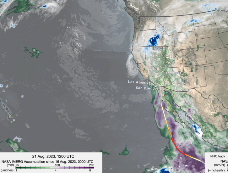
NASA’s IMERG algorithm uses precipitation estimates from the GPM Core Observatory satellite to calibrate estimates from other GPM constellation satellites to produce precipitation maps covering nearly the entire globe every 30 minutes. The above animation shows IMERG surface rainfall estimates associated with the passage of Hilary, following the storm from the East Pacific, into the Baja, across southern California, and into Nevada. IMERG shows that the heaviest rains associated with Hilary remained well offshore over the eastern Pacific where Hilary formed, and south of Baja where Hilary intensified into a major hurricane, with totals over 8 inches (200 mm) shown in dark purple. Over land the heaviest rainfall was along the western coast of mainland Mexico. Some of this rain, as well as that over Arizona, was not directly from Hilary’s circulation but due to the general southerly flow of moisture into the region triggering thunderstorms. However, Hilary’s rainbands and onshore flow did contribute significantly to the rain along the western slopes of the Sierra Madre as it approached southern Baja. Over Baja, IMERG shows that nearly the entire peninsula received at least 1 to 4 inches of rain (25 to 100 mm, shown in green) with the highest amounts of 4 to 6 inches of rain (100 to 150 mm, shown in lighter purples) over the central-west coast where Hilary nearly made landfall, and over the northern parts of the peninsula up to the U.S. border. Overall, IMERG shows that rainfall amounts along Hilary’s path decreased significantly as the storm moved north from the East Pacific up through the Southwest U.S. and into Idaho. This is due primarily to the fact that Hilary continued to speed up after turning northward, meaning less time dwelling over a given area, and the storm having less access to moisture over cooler waters and land.
Over the Southwestern U.S., IMERG shows that most of southern California, Nevada, western Arizona, and Utah as well as parts of Idaho, southeastern Oregon and southern Montana received from 1 to 3 inches of rain (25 to 75 mm, shown in green) from Hilary. Higher amounts on the order of 3 to 5 inches (~75 to 125 mm, shown in light green and purple) are located across parts of southern California and western Arizona. Locally higher amounts up to and exceeding 10 inches were reported in some of the higher terrain areas east of Los Angeles and San Diego. While the overall rainfall amounts may not initially appear to be very high, they represent a substantial amount in terms of the average annual rainfall for parts of this region. Palm Springs, CA, received about 6 months’ worth of rain from Hilary, while Death Valley, which typically receives about 2 inches of rain annually, received that much in less than a day from Hilary. In this arid climate with its lack of vegetation, this intense amount of rain in such a short period can lead to widespread flash flooding, which has been the case with Hilary with numerous reports of flash flooding, mudslides, and road closures across the region.
Credits:
Animation by Jason West (NASA GSFC, PPS, KBR)
Story by Stephen Lang (NASA GSFC, SSAI) & Jacob Reed (NASA GSFC, Telophase)

